Photogrammetry Software Market
写真測量ソフトウェア市場調査レポート情報写真測量タイプ別(航空写真測量、地上写真測量または近距離写真測量、衛星写真測量、水中写真測量、その他)、導入モード別(オンプレミスおよびクラウドベース(SaaS))、価格モデル別(商用/独自ソフトウェア、オープンソースソフトウェア)、最終用途別(建築、エンジニアリング、建設(AEC)、測量およびマッピング、鉱業および天然資源、石油およびガス、農業および林業、文化遺産および考古学、防衛およびセキュリティ、製造および産業、映画、アニメーション、ゲーム、研究および教育)、地域別(北米、ヨーロッパ、アジア太平洋、南米、中東およびアフリカ)–2035年までの市場予測
世界の写真測量ソフトウェア市場の概要
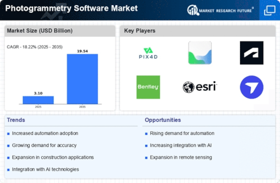
写真測量ソフトウェア市場の規模は、2024年に285億1,000万米ドルと評価されました。世界の写真測量ソフトウェア業界は、2025年の330億8,000万米ドルから2035年には909億7,000万米ドルに成長すると予測されており、予測期間(2025~2035年)中に17.6%の複合年間成長率(CAGR)を示します。
3Dモデルと3Dモデリングの需要の増加様々な業界の地図、航空および地上画像技術の進歩、そして航空データキャプチャのためのドローンとUAVの採用の増加は、写真測量ソフトウェア市場を牽引しています。
MRFRのアナリストによると、「急速に進化する地理空間技術とソフトウェア開発業界は、写真測量ソフトウェア市場の成長を促進する重要な要因です。写真測量ソフトウェアは、ドローンやその他の情報源によってキャプチャされた航空画像と衛星画像を正確な3Dモデルと詳細な地図に変換する上で重要な役割を果たします。これらのソフトウェアソリューションは、都市計画、建設、農業、環境モニタリング、考古学など、さまざまな分野で応用されています。」
出典:二次調査、一次調査、MRFRデータベース、およびアナリストレビュー
写真測量ソフトウェア市場の動向
写真測量ソフトウェアへの人工知能(AI)と機械学習(ML)の統合
写真測量ソフトウェアへの人工知能と機械学習(ML)の統合により、データ処理が改善され、アプリケーションの範囲が拡大します。これにより、ソフトウェアソリューションはよりアクセスしやすく、効率的で正確になります。これらのテクノロジーは、さまざまな業界の進化するニーズに応え、この分野のイノベーションを促進することで、写真測量市場の成長を促進する可能性があります。
人工知能と機械学習は、写真測量におけるデータ処理の自動化に非常に重要です。これらのテクノロジーは、特徴検出、オブジェクト識別、データ分類などのタスクに優れており、従来の労働集約的なデータ処理ワークフローを合理化します。同様に、写真測量ソフトウェアにAIとMLを統合することで、3Dモデリングのデータ精度が向上します。これらのテクノロジーは、広範なデータセットから学習して適応することで、データのマッチングと特徴抽出を微調整できます。つまり、写真測量データの精度が向上します。
さらに、米国連邦緊急事態管理庁(FEMA)によると、タイムリーで正確な情報が重要な緊急管理では、リアルタイムデータの価値が重要です。AI駆動型写真測量ソフトウェアは、リアルタイムのデータ洞察を提供し、災害対応、都市計画、環境モニタリングなどの分野で迅速な意思決定を促進します。近い将来、写真測量ソフトウェアの需要が高まるでしょう。さらに、AIとMLにより、写真測量ソフトウェアを特定の業界のアプリケーションに合わせてカスタマイズおよび適応できるようになります。これらのテクノロジーは、建設や農業などの分野に特有のパターンや変化を認識するようにトレーニングすることができ、ソフトウェアの汎用性を高めます。このような適応性により、3Dモデリングとマッピングのメリットを享受できる潜在的なアプリケーションと業界の範囲が広がります。
写真測量ソフトウェア市場セグメントの洞察
写真測量タイプ別の世界の写真測量ソフトウェアの洞察
このレポートでは、写真測量ソフトウェア市場は、写真測量タイプに基づいて、航空写真測量、地上写真測量または近距離写真測量、衛星写真測量、水中写真測量、およびその他に分類されています。航空写真測量セグメントは2024年に世界市場を支配しましたが、衛星写真測量は予測期間中に最も急速に成長するセグメントになると予測されています。
航空写真測量は、特定のエリアをマッピングするために使用される写真測量手法です。航空写真測量を使用すると、高解像度の写真をキャプチャしながら、1回の飛行で広い土地をカバーできます。このタイプを使用すると、タイムリーな情報と地面の最新のスナップショットの両方を提供できます。この手順は迅速かつ安価で、画像処理は様々な分野に適用できます。建設業も航空写真の利用から恩恵を受けています。映画製作、考古学、環境研究など、この分野では航空写真が使用されています。地図作成は航空写真の主な用途です。
さらに、2023年6月には、CHCナビゲーションのC5およびC30航空測量カメラが、比類のない精度と効率で航空写真測量を提供しました。無人航空機(UAV)とシームレスに統合され、優れた画質を生み出す最先端のカメラにより、専門家は航空測量の潜在能力を最大限に活用できます。航空分野向けのカメラの発売は、予測期間中の市場の成長を促進します。
導入モデル別のグローバル写真測量ソフトウェアの洞察
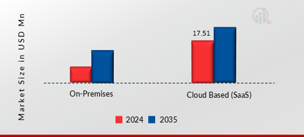
本レポートでは、写真測量ソフトウェア市場は、導入モードに基づいてオンプレミスとクラウドベース(SaaS)に分類されています。クラウドベース(SaaS)セグメントは2024年に世界市場を支配しましたが、クラウドベース(SaaS)は予測期間中に最も急速に成長するセグメントになると予測されています。
クラウドベースのソフトウェアは、スマートフォン、タブレット、デスクトップコンピューターで使用でき、インターネットに接続できるあらゆるマシンからいつでもアクセスできます。これにより、究極の柔軟性が得られ、モデル作成時にマシンに負担がかからず、より多くのデータをより速く、より少ないクラッシュで処理できます。クラウドベースのソリューションでは、オンプレミスのソフトウェア、サーバー、およびハードウェアのアップグレードを購入するための多額の先行投資を回避することもできます。
図1:写真測量ソフトウェア市場、導入モデル別、2024年および2035 年 (10 億米ドル)
価格モデルによる世界の写真測量ソフトウェアの洞察
このレポートの写真測量ソフトウェア市場は、価格モデルに基づいて、商用/独自ソフトウェアとオープンソースソフトウェアに分類されています。商用/独自ソフトウェアセグメントは 2024 年に世界市場を支配しましたが、オープンソースソフトウェアは予測期間中に最も急速に成長するセグメントになると予測されています。
商用または独自仕様の写真測量ソフトウェアは、民間企業によって開発および販売されるソフトウェアアプリケーションおよびツールであり、そのソースコードは通常、一般には公開されていません。これらのソフトウェア パッケージは、オープンソースの写真測量ソフトウェアと同様に、写真を処理して 3D モデル、マップ、再構築を作成するように設計されています。市販の写真測量ソフトウェアは、地理情報システム (GIS) やコンピューター支援設計 (CAD) ソフトウェアなどの他のソフトウェア ツールとシームレスに連携するように設計されており、建築、エンジニアリング、測量などの分野の専門家にとって重要です。
これらのツールは、建設、農業、林業、考古学、エンターテイメント業界など、高精度の 3D モデルと再構築が必要なさまざまな業界で広く使用されています。ユーザーは通常、特定のニーズ、予算、プロジェクトに必要なサポートと機能のレベルに基づいて、市販の写真測量ソフトウェアとオープンソースの写真測量ソフトウェアのどちらかを選択します。商用ソフトウェアは、信頼性が高く機能豊富なソリューションを必要とする専門ユーザーや組織にとって好ましい選択肢となる可能性があります。
価格設定モデルの洞察による世界の写真測量ソフトウェア
このレポートの写真測量ソフトウェア市場は、業界に基づいて、建築、エンジニアリング、建設(AEC)、測量とマッピング、鉱業と天然資源、石油とガス、農林業、文化遺産と考古学、防衛とセキュリティ、製造と工業、映画、アニメーション、ゲーム、研究と教育に分類されています。建築、エンジニアリング、建設(AEC)セグメントは2024年に世界市場を支配しましたが、測量とマッピングは予測期間中に最も急速に成長するセグメントになると予測されています。
3Dモデルの写真測量プリントは、3Dスキャン技術として人気が高まっており、よりアクセスしやすくなっています。中古の写真測量ソフトウェアを使用して、写真や動画を仮想のものに変えます。 3Dモデリングとフォトリアリスティックレンダリング(フォトリアリスティック彫刻とも呼ばれる)という2つの主要なアプローチを使用して、リアルな画像またはモデルを作成します。ソフトウェアは、建築、エンジニアリング、測量などの分野の専門家にも役立ちます。 3Dプリンティングは飛躍的に進歩しました。製造、カスタムアートとデザイン、医療など、さまざまなアプリケーションで重要な役割を果たします。
迅速なプロトタイピングのための最も人気のある方法の1つは、縮小された現実世界のものの3Dレプリカです。さまざまなアプリケーションにわたる3Dプリンティングにより、予測期間中の市場の成長が促進されます。たとえば、2022年12月、SynopsysはSimple ware U-2022.12 3Dイメージソフトウェアを発表しました。最新のSimple wareソフトウェアエディションでは、多数の新機能と拡張機能が提供されています。これには、Simple ware Ortho / CMFモジュールの頭蓋顎顔面(CMF)CTツール、スマートペイントツール、3Dプリントの自動コネクタの可能性、およびさらなる材料評価が含まれます。これらの要因がセグメントの成長を加速させています。
世界の写真測量ソフトウェアの地域別洞察
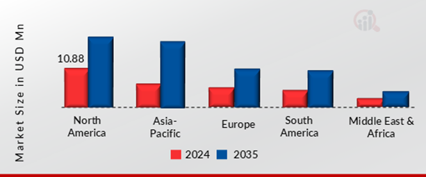
写真測量ソフトウェア市場は、北米、ヨーロッパ、アジア太平洋、南米、中東およびアフリカに分割されています。北米地域は、2024年に108億8,000万米ドルの市場価値で最大の市場シェアを占め、2035年には329億9,000万米ドルに達し、2024年から2035年にかけて16.6%のCAGRで成長すると予想されています。
米国、カナダ、メキシコを含む北米は、写真測量市場の重要な地域です。北米は、3Dビデオゲーム業界で最も急速に成長している地域の1つです。この地域ではゲームコンソールの売上が高く、そのため、コンソールゲームは北米の開発者やパブリッシャーにとって主な焦点となっています。さらに、推計によると、米国のメディアおよびエンターテイメント部門が世界市場の最大のシェアを占めています。北米の写真測量ソフトウェア市場は、この技術の主要ユーザーの1つである3Dアニメーション映画の人気が高まっているため、収益の面で継続的に成長しています。
モーショングラフィックアニメーション映画の使用は拡大しており、予測期間中に北米の写真測量ソフトウェア市場の成長を促進するでしょう。この地域のベンダーは、研究開発活動に多額の投資を行っています。これにより、土地測量とともに、さまざまな地理空間活動における技術の進歩がさらに促進されています。米国は、デジタルデバイスの普及と、主に建築、地形図、エンジニアリングなどのアプリケーションでの写真測量ソフトウェアの広範な使用により、北米の写真測量ソフトウェアの売り上げで大きなシェアを占めると予測されています。
建設業界におけるGPS受信機の使用の増加は、写真測量ソフトウェア市場の成長を牽引する主な要因の1つです。 GPS 技術は、北米地域のメガプロジェクトの設備追跡や土木工事現場など、大規模建設プロジェクトで広く採用されています。
図 2:写真測量ソフトウェア市場、地域別、2024 年および 2035 年(10 億米ドル)
さらに、市場レポートで調査された主要国は、米国、カナダ、メキシコ、ドイツ、ドイツ、英国、フランス、イタリア、スペイン、ロシア、その他ヨーロッパ、中国、日本、インド、オーストラリア、インドネシア、韓国、その他アジア太平洋地域、GCC、南アフリカ、その他中東およびアフリカです。アフリカ、ブラジル、チリ、その他の南米諸国。
世界の写真測量ソフトウェア市場の主要プレーヤーと競合分析
写真測量ソフトウェア市場は、多くのグローバル、地域、そしてローカルベンダーによって特徴づけられています。市場は競争が激しく、すべてのプレーヤーが市場シェア獲得を目指してしのぎを削っています。激しい競争、技術の急速な進歩、政府の政策の頻繁な変更、そして環境規制は、市場の成長を阻む主要な要因です。ベンダーは、コスト、製品品質、信頼性、そして政府の規制に基づいて競争しています。ベンダーは、競争の激しい市場で生き残り、成功するためには、コスト効率が高く、高品質の製品を提供する必要があります。
市場の主要プレーヤーには、DRONEDEPLOY、AGISOFT LLC、Pix4d Sa、Bentley Systems、Inc、Autodesk Inc、PHOTOMODELER Technologies、Esri、PIXPRO、POLYCAM、REALITYCAPTURE、3df Zephyr、3dsurvey、ALICEVISION、MAPWARE、VEXCEL Imaging、Adobe、Leica Geosystems Ag(Hexagon)、ARTEC Studio 19、SCANPOINT Geomatics Ltd、DJI、などが含まれます。写真測量ソフトウェア市場は、競争の激化、買収、合併、その他の戦略的な市場動向、そして業務効率向上のための意思決定により、統合市場となっています。
写真測量ソフトウェア市場の主要企業は以下の通りです。
- DRONEDEPLOY
- AGISOFT LLC
- Pix4d Sa
- Bentley Systems, Inc
- Autodesk Inc
- PHOTOMODELER Technologies
- Esri
- PIXPRO
- POLYCAM
- REALITYCAPTURE
- 3df Zephyr
- 3dsurvey
- ALICEVISION
- MAPWARE
- VEXCELイメージング
- Adobe
- Leica Geosystems Ag (Hexagon)
- ARTEC Studio 19
- SCANPOINT Geomatics Ltd
- DJI
写真測量ソフトウェア市場のセグメンテーション
写真測量ソフトウェア市場:写真測量タイプ別展望(10億米ドル、2019~2035年)
- 航空写真測量
- 地上および近距離写真測量
- 衛星写真測量
- 水中写真測量
- その他
写真測量ソフトウェア市場:導入モデル別展望(10億米ドル、 2019年~2035年)
- オンプレミス
- クラウドベース(SaaS)
写真測量ソフトウェア市場:価格モデル別展望(10億米ドル、2019年~2035年)
- 商用/独自ソフトウェア
- オープンソースソフトウェア
写真測量ソフトウェア市場:エンドユーザー別展望(10億米ドル、2019年~2035年)
- 建築・エンジニアリング・建設(AEC)
- 測量・マッピング
- 鉱業・天然資源
- 石油・ガス
- 農林業
- 文化遺産・考古学
- 防衛・セキュリティ
- 製造業および工業
- 映画、アニメーション、ゲーム
- 研究および教育
グローバル写真測量ソフトウェア地域別展望
- 北米
- 米国
- カナダ
- メキシコ
- ヨーロッパ
- ドイツ
- 英国
- フランス
- イタリア
- スペイン
- ロシア
- その他ヨーロッパ
- アジア太平洋地域
- 中国
- 日本
- インド
- オーストラリア
- インドネシア
- 韓国
- その他のアジア太平洋地域
- 南米
- ブラジル
- チリ
- その他の南米地域
- 中東
- GCC諸国
- 南アフリカ
- その他の中東およびアフリカ地域
FAQs
What is the current valuation of the Photogrammetry Software Market?
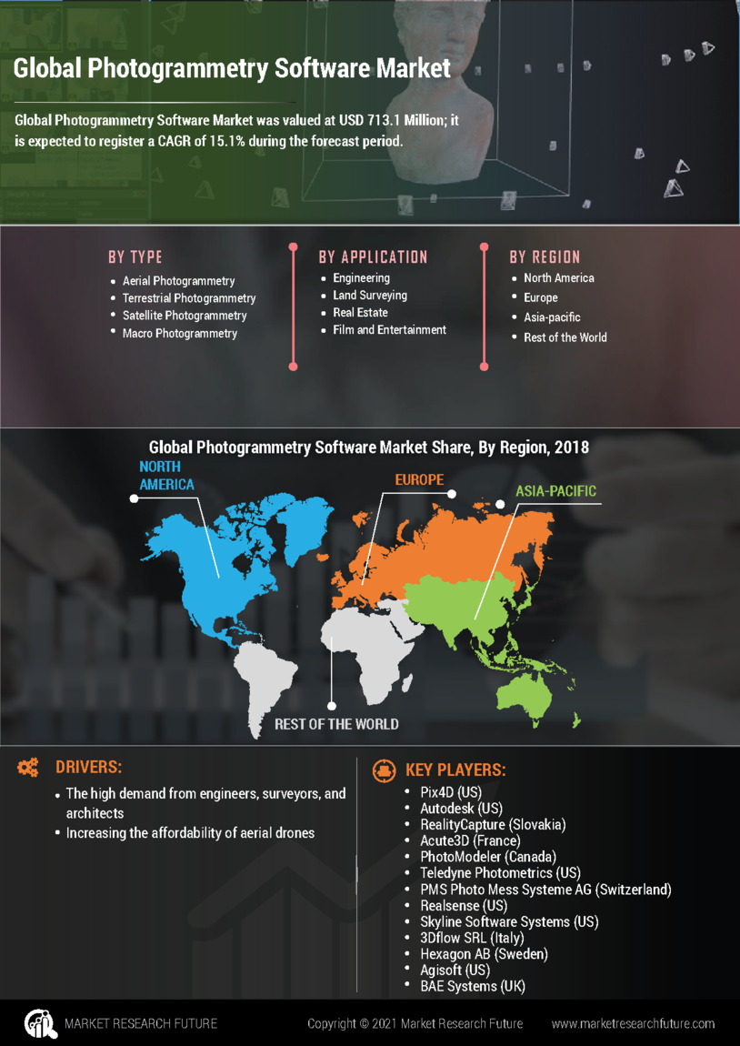
The Photogrammetry Software Market was valued at 3.1 USD Billion in 2024.
What is the projected market size for the Photogrammetry Software Market by 2035?
The market is projected to reach 19.54 USD Billion by 2035.
What is the expected CAGR for the Photogrammetry Software Market during the forecast period?
The expected CAGR for the Photogrammetry Software Market from 2025 to 2035 is 18.22%.
Which segments are included in the Photogrammetry Software Market?
Key segments include Aerial, Terrestrial, Satellite, and Underwater Photogrammetry.
What are the leading companies in the Photogrammetry Software Market?
Key players include Pix4D, Agisoft, Autodesk, and Bentley Systems.
How does the deployment model affect the market valuation?
The On-Premises and Cloud Based (SaaS) deployment models are each valued at 1.55 USD Billion in 2024.
このレポートの無料サンプルを受け取るには、以下のフォームにご記入ください
Customer Stories

“This is really good guys. Excellent work on a tight deadline. I will continue to use you going forward and recommend you to others. Nice job”

“Thanks. It’s been a pleasure working with you, please use me as reference with any other Intel employees.”

“Thanks for sending the report it gives us a good global view of the Betaïne market.”

“Thank you, this will be very helpful for OQS.”

“We found the report very insightful! we found your research firm very helpful. I'm sending this email to secure our future business.”

“I am very pleased with how market segments have been defined in a relevant way for my purposes (such as "Portable Freezers & refrigerators" and "last-mile"). In general the report is well structured. Thanks very much for your efforts.”

“I have been reading the first document or the study, ,the Global HVAC and FP market report 2021 till 2026. Must say, good info! I have not gone in depth at all parts, but got a good indication of the data inside!”

“We got the report in time, we really thank you for your support in this process. I also thank to all of your team as they did a great job.”
