• Cat-intel
  • MedIntelliX
  • Resources
  • About Us
  • Request Free Sample ×

    Kindly complete the form below to receive a free sample of this Report

    Leading companies partner with us for data-driven Insights

    clients tt-cursor
    Hero Background

    US Photogrammetry Software Market

    ID: MRFR/ICT/14950-HCR
    100 Pages
    Garvit Vyas
    October 2025

    US Photogrammetry Software Market Research Report: By Photogrammetry Type (Aerial Photogrammetry, Terrestrial Photogrammetry, Close-Range Photogrammetry, Satellite Photogrammetry, Underwater Photogrammetry, Others), By Deployment Mode (On-premises, Cloud-based), By Pricing Model (Commercial/Proprietary Software, Open-Source Software) and By End Use Vertical (Architecture, Engineering, Construction (AEC), Surveying and Mapping, Mining and Natural Resources, Oil and Gas, Agriculture and Forestry, Cultural Heritage and Archaeology, Defense and...

    Share:
    Download PDF ×

    We do not share your information with anyone. However, we may send you emails based on your report interest from time to time. You may contact us at any time to opt-out.

    US Photogrammetry Software Market Infographic
    Purchase Options

    US Photogrammetry Software Market Summary

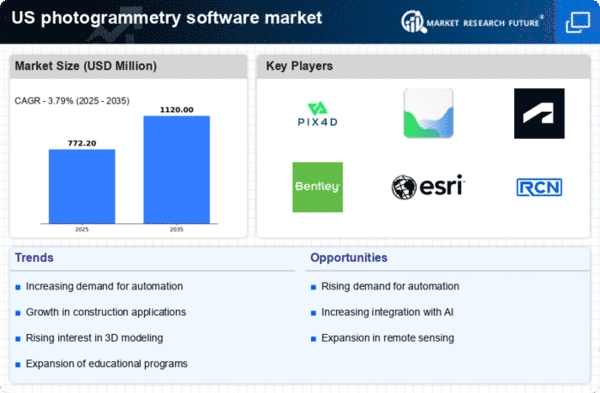
    As per MRFR analysis, the US photogrammetry software market size was estimated at 744.0 USD Million in 2024. The US photogrammetry software market is projected to grow from 772.2 USD Million in 2025 to 1120.0 USD Million by 2035, exhibiting a compound annual growth rate (CAGR) of 3.79% during the forecast period 2025 - 2035.

    Key Market Trends & Highlights

    The US photogrammetry software market is experiencing robust growth driven by technological advancements and increasing applications across various sectors.

    • The construction segment remains the largest, reflecting a notable increase in photogrammetry adoption for project management and site analysis.
    • Drone technology integration is rapidly transforming the market, enhancing data collection and analysis capabilities in real-time.
    • Environmental applications are gaining traction, as organizations seek to leverage photogrammetry for sustainability and conservation efforts.
    • Technological advancements in imaging and the growing demand in surveying and mapping are key drivers propelling market expansion.

    Market Size & Forecast

    2024 Market Size 744.0 (USD Million)
    2035 Market Size 1120.0 (USD Million)

    Major Players

    Pix4D (CH), Agisoft (RU), Autodesk (US), Bentley Systems (US), Esri (US), RealityCapture (SK), DroneDeploy (US), 3D Survey (AU), Maptek (AU)

    US Photogrammetry Software Market Trends

    The photogrammetry software market is currently experiencing notable growth. This growth is driven by advancements in technology and increasing applications across various sectors. Industries such as construction, agriculture, and environmental monitoring are increasingly adopting photogrammetry solutions for their ability to create accurate 3D models and maps. This trend appears to be fueled by the demand for precision and efficiency in project execution, as organizations seek to enhance productivity and reduce costs. Furthermore, The integration of artificial intelligence and machine learning into photogrammetry software is likely to improve data processing capabilities. This improvement will make it easier for users to derive insights from complex datasets. In addition, the rise of drone technology has significantly impacted the photogrammetry software market. Drones equipped with high-resolution cameras are now widely used for aerial surveys, enabling the collection of vast amounts of data in a fraction of the time compared to traditional methods. This shift not only enhances the accuracy of data collection but also broadens the scope of applications, from urban planning to disaster management. As the market continues to evolve, it seems poised for further expansion, with innovations in software capabilities and hardware integration paving the way for new opportunities and applications in the future.

    Increased Adoption in Construction

    The construction sector increasingly utilizes photogrammetry software for project planning and monitoring. This trend indicates a shift towards more efficient workflows, as companies leverage the technology to create detailed site models and track progress in real-time.

    Integration with Drone Technology

    The incorporation of drone technology into photogrammetry practices is transforming data collection methods. Drones facilitate rapid aerial surveys, allowing for the generation of high-resolution imagery and 3D models, which enhances the accuracy and efficiency of various applications.

    Focus on Environmental Applications

    There is a growing emphasis on using photogrammetry software for environmental monitoring and management. This trend suggests a heightened awareness of sustainability, as organizations employ the technology to assess land use, track changes in ecosystems, and support conservation efforts.

    US Photogrammetry Software Market Drivers

    Emergence of Cloud-Based Solutions

    The emergence of cloud-based solutions is transforming the photogrammetry software market. This transformation enhances accessibility and collaboration. Cloud platforms allow users to store, process, and share large datasets seamlessly, facilitating teamwork among professionals in different locations. This shift is particularly beneficial for industries that require real-time data analysis and sharing, such as construction and environmental monitoring. As organizations increasingly adopt cloud technologies, the photogrammetry software market is likely to witness a significant uptick in demand for cloud-compatible solutions. This trend suggests a future where cloud integration becomes a standard feature, further driving innovation and efficiency within the photogrammetry software market.

    Rising Popularity of 3D Visualization

    The growing popularity of 3D visualization in various industries is a key driver for the photogrammetry software market. Businesses in sectors such as real estate, gaming, and virtual reality are increasingly utilizing photogrammetry to create immersive experiences and realistic representations of environments. This trend is fostering a greater appreciation for the capabilities of photogrammetry software, as it allows for the transformation of 2D images into detailed 3D models. The market is expected to expand as more companies recognize the value of high-quality visual content, potentially leading to a market growth rate of 12% over the next few years. This shift towards 3D visualization highlights the evolving landscape of the photogrammetry software market.

    Technological Advancements in Imaging

    The photogrammetry software market is experiencing a surge due to rapid technological advancements in imaging techniques. Innovations such as high-resolution cameras and advanced sensors are enhancing the accuracy and efficiency of photogrammetric processes. These developments enable users to capture detailed images and generate precise 3D models, which are crucial in various sectors, including construction and surveying. The integration of artificial intelligence and machine learning algorithms further streamlines data processing, making it more accessible for professionals. As a result, the market is projected to grow at a CAGR of approximately 15% over the next five years, driven by the increasing demand for high-quality imaging solutions in the photogrammetry software market.

    Growing Demand in Surveying and Mapping

    The demand for photogrammetry software is significantly increasing in the surveying and mapping sectors. Professionals in these fields are leveraging photogrammetry to create accurate topographical maps and 3D models of landscapes. This trend is largely driven by the need for precise data in urban planning, environmental monitoring, and infrastructure development. The photogrammetry software market is projected to reach a valuation of $1.5 billion by 2026, reflecting a robust growth trajectory. The ability to produce detailed and reliable data quickly is becoming essential for surveyors, thereby propelling the adoption of photogrammetry solutions. This growing reliance on advanced mapping technologies indicates a strong future for the photogrammetry software market.

    Increased Investment in Infrastructure Projects

    The photogrammetry software market is benefiting from increased investment in infrastructure projects across the United States. Government initiatives aimed at improving transportation networks, utilities, and public facilities are driving the demand for accurate surveying and modeling tools. Photogrammetry software plays a vital role in these projects by providing precise measurements and visualizations, which are essential for effective planning and execution. As infrastructure spending is expected to rise by 10% annually, the photogrammetry software market is likely to see a corresponding increase in demand. This trend underscores the importance of photogrammetry in supporting large-scale construction and development efforts.

    Market Segment Insights

    By Photogrammetry Type: Aerial Photogrammetry (Largest) vs. Terrestrial Photogrammetry (Fastest-Growing)

    In the US photogrammetry software market, Aerial Photogrammetry holds the largest share, leveraging advancements in drone technology and aerial imaging. This segment is widely adopted across industries such as construction, mining, and agriculture, underscoring its critical role in data collection and analysis. Terrestrial Photogrammetry, while smaller in market share, has gained traction as it offers precise ground-level data capture, making it attractive for applications like topographic surveys and environmental monitoring. Growth trends indicate a robust increase in demand for Terrestrial Photogrammetry, driven by technological advancements and rising applications in urban planning and forestry management. Such growth is further fueled by the need for detailed and accurate spatial data, pushing companies to invest in software solutions that enhance data processing capabilities. As industries seek more reliable and efficient methods for data collection, the competition between these segments intensifies, positioning them for significant growth in the coming years.

    Aerial Photogrammetry (Dominant) vs. Terrestrial Photogrammetry (Emerging)

    Aerial Photogrammetry is the dominant segment in the US photogrammetry software market, primarily due to its ability to capture large areas quickly and efficiently. The integration of UAVs has revolutionized this segment, allowing for high-resolution imagery and data collection at unprecedented speeds. In contrast, Terrestrial Photogrammetry is emerging with unique strengths, focusing on highly precise, localized data capture. This segment appeals to niche markets such as engineering, infrastructure development, and precise modeling. The competition between these segments signifies a pivotal shift in how spatial data is collected and utilized, reflecting broader trends of digital transformation across industries.

    By Deployment Model: Cloud Based (SaaS) (Largest) vs. On-Premises (Fastest-Growing)

    In the US photogrammetry software market, the distribution of deployment models showcases a clear preference for Cloud Based (SaaS) solutions, which currently hold the largest market share. This model has gained traction due to its accessibility and ease of use, allowing users to leverage high-performance computing without the need for extensive hardware investments. Conversely, On-Premises solutions have been steadily increasing their presence in the market as organizations seek greater control and data security, contributing to its recognition as a fast-growing segment. The growth trends within the deployment model segment are influenced by several factors. The rise of remote work has accelerated the adoption of Cloud Based software, enabling collaborative projects and real-time data sharing among teams. Meanwhile, organizations that prioritize security and compliance are driving demand for On-Premises solutions, valuing the enhanced control over sensitive data. As both deployment models evolve, they cater to distinct user preferences, creating a dynamic and competitive landscape in the market.

    Deployment Model: Cloud Based (SaaS) (Dominant) vs. On-Premises (Emerging)

    Cloud Based (SaaS) solutions are dominating the current landscape of the US photogrammetry software market, characterized by their scalability and versatility. These solutions allow users to access advanced photogrammetry tools via the internet, minimizing the need for significant upfront capital investment in hardware. The focus on user-friendly interfaces and integration capabilities also appeals to a wide range of users, from small enterprises to large corporations. In contrast, On-Premises solutions are emerging as strong contenders, particularly among organizations that prioritize data security and infrastructure control. These installations often require substantial initial investment and maintenance, yet they cater to particular industry needs necessitating rigorous compliance. This rivalry between Cloud Based and On-Premises models reflects a broader trend in the software market, where customer demands dictate rapid advancements.

    By Pricing Model: Commercial/Proprietary Software (Largest) vs. Open-Source Software (Fastest-Growing)

    The market share distribution in the pricing model segment reveals that Commercial/Proprietary Software holds the largest segment share, favored by professionals and organizations for its robust features, dedicated support, and frequent updates. In contrast, Open-Source Software is gaining traction, driven by its cost-effectiveness and flexibility, appealing particularly to startups and individual users looking to avoid high licensing costs. Growth trends illustrate a significant shift towards Open-Source Software as more users recognize its advantages in customization and community-driven development. This segment is expected to grow rapidly as demand for innovative, collaborative solutions increases. The flexibility of Open-Source options allows users to adapt their tools as needed, making it an attractive alternative in a competitive market environment.

    Commercial/Proprietary Software (Dominant) vs. Open-Source Software (Emerging)

    Commercial/Proprietary Software is dominant in the pricing model segment, often sought after for its tried-and-tested capabilities, comprehensive support, and dedicated resources for updates and enhancements. This type of software typically comes with a subscription or one-time purchase fee, providing businesses with confidence in reliability and functionality. In contrast, Open-Source Software represents an emerging segment that is rapidly gaining popularity, particularly among independent developers and small businesses. Its no-cost entry point, combined with a collaborative development model, allows for high customization and rapid innovation. Users can access a wide array of tools that meet diverse project needs while minimizing financial risks, fostering a greater sense of community and shared knowledge.

    By End-Use Vertical: Architecture, Engineering, And Construction (Largest) vs. Surveying And Mapping (Fastest-Growing)

    In the US photogrammetry software market, the distribution of market share across various end-use verticals showcases a rich diversity of applications. The Architecture, Engineering, and Construction (AEC) sector claims the largest share due to its essential role in modern infrastructure development, whereas the Surveying and Mapping segment is catching up rapidly, driven by technological advancements and increasing demand for accurate spatial data in various fields. Furthermore, growth trends reflect a strong expansion in the Surveying and Mapping sector, characterized by rising investments in geospatial technology and an increasing need for precise mapping solutions. Market drivers include the growth of smart cities, enhanced surveying capabilities, and the integration of photogrammetry with GIS technologies. As industries evolve, the demand for specialized software in sectors such as Mining and Natural Resources and Oil and Gas continues to grow, bridging technology and application.

    AEC (Dominant) vs. Surveying And Mapping (Emerging)

    The Architecture, Engineering, and Construction (AEC) sector remains dominant in the US photogrammetry software market, employing cutting-edge technology to enhance the design and construction process. AEC uses photogrammetry for various applications such as site analysis, building information modeling (BIM), and project management, facilitating improved coordination and efficiency in construction projects. On the other hand, the Surveying and Mapping segment is an emerging power, leveraging state-of-the-art techniques for land surveying and environmental monitoring. Driven by a demand for accuracy in mapping and the uptick in geo-spatial analytics, this segment is seeing significant growth, fueled by the integration of photogrammetry with other technologies and the increasing awareness of the benefits of precise spatial data across numerous sectors.

    Get more detailed insights about US Photogrammetry Software Market

    Key Players and Competitive Insights

    The photogrammetry software market is characterized by a dynamic competitive landscape, driven by technological advancements and increasing demand for 3D modeling across various sectors, including construction, agriculture, and environmental monitoring. Key players such as Autodesk (US), Esri (US), and DroneDeploy (US) are strategically positioned to leverage innovation and partnerships to enhance their offerings. Autodesk (US) focuses on integrating photogrammetry capabilities into its broader design software suite, while Esri (US) emphasizes the incorporation of geospatial data analytics to improve decision-making processes. DroneDeploy (US) is enhancing its cloud-based platform to facilitate real-time data processing, which collectively shapes a competitive environment that prioritizes technological integration and user-centric solutions.

    The market structure appears moderately fragmented, with numerous players vying for market share. Key business tactics include localizing software solutions to meet regional needs and optimizing supply chains to ensure timely delivery of services. The collective influence of these major players fosters a competitive atmosphere where innovation and customer engagement are paramount, allowing them to differentiate themselves in a crowded marketplace.

    In October 2025, Autodesk (US) announced the launch of a new photogrammetry tool that integrates AI-driven features to automate the 3D modeling process. This strategic move is likely to enhance user experience by reducing the time required for data processing and improving accuracy, thereby positioning Autodesk (US) as a leader in innovation within the market. The introduction of such advanced features may attract a broader customer base, particularly among industries that require rapid and precise modeling capabilities.

    In September 2025, Esri (US) expanded its partnership with several drone manufacturers to enhance the integration of aerial imagery into its GIS platforms. This collaboration is significant as it allows Esri (US) to offer more comprehensive solutions that combine photogrammetry with advanced geospatial analytics. By strengthening its ecosystem, Esri (US) is likely to enhance its competitive edge, appealing to clients who seek integrated solutions for complex spatial analysis.

    In August 2025, DroneDeploy (US) launched a new feature that allows users to conduct real-time analysis of drone-captured data directly within its platform. This development is crucial as it addresses the growing demand for immediate insights in industries such as construction and agriculture. By enabling users to make data-driven decisions on-site, DroneDeploy (US) is likely to solidify its position as a go-to solution for professionals seeking efficiency and accuracy in their operations.

    As of November 2025, the competitive trends in the photogrammetry software market are increasingly defined by digitalization, sustainability, and the integration of AI technologies. Strategic alliances among key players are shaping the landscape, fostering innovation and enhancing service delivery. The shift from price-based competition to a focus on technological advancement and supply chain reliability is evident, suggesting that future competitive differentiation will hinge on the ability to innovate and adapt to evolving market demands.

    Key Companies in the US Photogrammetry Software Market market include

    Industry Developments

    The US Photogrammetry Software Market has seen significant advancements and developments recently. Bentley Systems has reported enhancements in their software offerings focused on improving data accuracy and workflow efficiency, while DroneDeploy has launched new features aimed at optimizing aerial imagery processing for various industries, including agriculture and construction. In September 2023, SimActive announced an update to their Correlator3D software, which enhances processing speed, a crucial factor as market demand grows. Recently, in October 2023, Blue Marble Geographics completed a strategic partnership with Esri to integrate their software solutions, leveraging both companies' strengths for improved geospatial data analysis.

    In terms of mergers and acquisitions, Hexagon AB acquired Gazef. This acquisition, announced in July 2023, aims to enhance Hexagon's capabilities in digital geospatial technologies. Market growth is expected to continue, driven by increasing demand in industries such as construction, land surveying, and environmental monitoring. As of mid-2023, major players, including Pix4D and Agisoft, have reported revenue growth, attributing advancements to increased adoption of drone technology and advancements in AR and VR applications. The US market is poised for further innovation as these companies continue to enhance their offerings.

    Future Outlook

    US Photogrammetry Software Market Future Outlook

    The photogrammetry software market is projected to grow at a 3.79% CAGR from 2024 to 2035, driven by advancements in technology and increasing demand across various sectors.

    New opportunities lie in:

    • Integration of AI-driven analytics for enhanced data processing efficiency.
    • Development of mobile photogrammetry solutions for field applications.
    • Partnerships with construction firms for real-time project monitoring.

    By 2035, the market is expected to achieve substantial growth, reflecting evolving technological demands.

    Market Segmentation

    US Photogrammetry Software Market Pricing Model Outlook

    • Commercial/Proprietary Software
    • Open-Source Software

    US Photogrammetry Software Market Deployment Model Outlook

    • On-Premises
    • Cloud Based (SaaS)

    US Photogrammetry Software Market End-Use Vertical Outlook

    • Architecture, Engineering, And Construction (AEC)
    • Surveying And Mapping
    • Mining And Natural Resources
    • Oil And Gas
    • Agriculture And Forestry
    • Cultural Heritage And Archaeology
    • Defense And Security
    • Manufacturing And Industrial
    • Film, Animation, And Gaming
    • Research And Education

    US Photogrammetry Software Market Photogrammetry Type Outlook

    • Aerial Photogrammetry
    • Terrestrial Photogrammetry
    • Satellite Photogrammetry
    • Underwater Photogrammetry
    • Others

    Report Scope

    MARKET SIZE 2024 744.0(USD Million)
    MARKET SIZE 2025 772.2(USD Million)
    MARKET SIZE 2035 1120.0(USD Million)
    COMPOUND ANNUAL GROWTH RATE (CAGR) 3.79% (2024 - 2035)
    REPORT COVERAGE Revenue Forecast, Competitive Landscape, Growth Factors, and Trends
    BASE YEAR 2024
    Market Forecast Period 2025 - 2035
    Historical Data 2019 - 2024
    Market Forecast Units USD Million
    Key Companies Profiled Pix4D (CH), Agisoft (RU), Autodesk (US), Bentley Systems (US), Esri (US), RealityCapture (SK), DroneDeploy (US), 3D Survey (AU), Maptek (AU)
    Segments Covered Photogrammetry Type, Deployment Model, Pricing Model, End-Use Vertical
    Key Market Opportunities Integration of artificial intelligence enhances accuracy and efficiency in the photogrammetry software market.
    Key Market Dynamics Technological advancements drive innovation in photogrammetry software, enhancing accuracy and efficiency across various applications.
    Countries Covered US

    Leave a Comment

    FAQs

    What is the projected market size of the US Photogrammetry Software Market by 2035?

    The US Photogrammetry Software Market is projected to reach a value of approximately 4057.49 million USD by 2035.

    What is the expected compound annual growth rate (CAGR) for the US Photogrammetry Software Market from 2025 to 2035?

    The market is expected to achieve a CAGR of 18.098 percent during the forecast period from 2025 to 2035.

    Which photogrammetry type is expected to dominate the market in 2035?

    Aerial Photogrammetry is anticipated to dominate the market, reaching a value of 900 million USD by 2035.

    What is the estimated market value of Terrestrial Photogrammetry in 2024?

    The market value of Terrestrial Photogrammetry is estimated to be around 120 million USD in 2024.

    Who are the key players in the US Photogrammetry Software Market?

    Major players in the market include Bentley Systems, DroneDeploy, Pix4D, Esri, and Maxar Technologies.

    What is the market value of Close-Range Photogrammetry in 2035?

    By 2035, Close-Range Photogrammetry is expected to reach a market value of 600 million USD.

    How is the Underwater Photogrammetry segment expected to perform by 2035?

    Underwater Photogrammetry is projected to grow to 440 million USD by 2035.

    What is the expected market size for Satellite Photogrammetry in 2024?

    The expected market size for Satellite Photogrammetry in 2024 is approximately 111 million USD.

    What emerging trends are influencing the US Photogrammetry Software Market?

    Technological advancements and increasing applications in various industries are key trends driving market growth.

    What challenges does the US Photogrammetry Software Market currently face?

    Challenges include data management complexities and competition among major players in the market.

    Download Free Sample

    Kindly complete the form below to receive a free sample of this Report

    Case Study
    Chemicals and Materials

    Compare Licence

    ×
    Features License Type
    Single User Multiuser License Enterprise User
    Price $4,950 $5,950 $7,250
    Maximum User Access Limit 1 User Upto 10 Users Unrestricted Access Throughout the Organization
    Free Customization
    Direct Access to Analyst
    Deliverable Format
    Platform Access
    Discount on Next Purchase 10% 15% 15%
    Printable Versions