• Cat-intel
  • MedIntelliX
  • Resources
  • About Us
  • Request Free Sample ×

    Kindly complete the form below to receive a free sample of this Report

    Leading companies partner with us for data-driven Insights

    clients tt-cursor
    Hero Background

    UK Photogrammetry Software Market

    ID: MRFR/ICT/60060-HCR
    200 Pages
    Aarti Dhapte
    October 2025

    UK Photogrammetry Software Market Research Report By Photogrammetry Type (Aerial Photogrammetry, Terrestrial Photogrammetry, Close-Range Photogrammetry, Satellite Photogrammetry, Underwater Photogrammetry, Others), By Deployment Mode (On-premises, Cloud-based), By Pricing Model (Commercial/Proprietary Software, Open-Source Software), and By End Use Vertical (Architecture, Engineering, Construction (AEC), Surveying and Mapping, Mining and Natural Resources, Oil and Gas, Agriculture and Forestry, Cultural Heritage and Archaeology, Defense and ...

    Share:
    Download PDF ×

    We do not share your information with anyone. However, we may send you emails based on your report interest from time to time. You may contact us at any time to opt-out.

    UK Photogrammetry Software Market Infographic
    Purchase Options

    UK Photogrammetry Software Market Summary

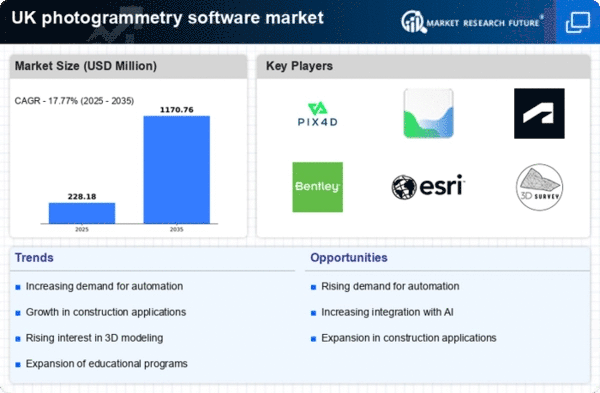
    As per MRFR analysis, The UK photogrammetry software market size was estimated at $193.75 Million in 2024. The UK photogrammetry software market is projected to grow from 228.18 $ Million in 2025 to 1170.76 $ Million by 2035, exhibiting a compound annual growth rate (CAGR) of 17.77% during the forecast period 2025 - 2035.

    Key Market Trends & Highlights

    The UK photogrammetry software market is experiencing robust growth driven by technological advancements and increasing applications across various sectors.

    • AI and machine learning integration is transforming photogrammetry software capabilities, enhancing accuracy and efficiency.
    • Cloud-based solutions are gaining traction, allowing for greater accessibility and collaboration among users in the photogrammetry sector.
    • Mobile application development is emerging as a key trend, facilitating on-the-go data capture and processing for users in the field.
    • Rising demand for 3D mapping solutions and increased investment in infrastructure development are significant drivers propelling market growth.

    Market Size & Forecast

    2024 Market Size 193.75 (USD Million)
    2035 Market Size 1170.76 (USD Million)

    Major Players

    Pix4D (CH), Agisoft (RU), Autodesk (US), Bentley Systems (US), Esri (US), 3D Survey (SK), RealityCapture (SK), DroneDeploy (US), Maptek (AU)

    UK Photogrammetry Software Market Trends

    The photogrammetry software market is currently experiencing notable growth. This growth is driven by advancements in technology and increasing demand across various sectors. Industries such as construction, agriculture, and heritage preservation are increasingly adopting photogrammetry solutions for their ability to create accurate 3D models and maps. This trend is further supported by the integration of artificial intelligence and machine learning, which enhances the efficiency and accuracy of data processing. As organizations seek to improve operational efficiency and reduce costs, the adoption of photogrammetry software is likely to expand, reflecting a shift towards more data-driven decision-making processes. Moreover, the rise of remote sensing technologies and the growing emphasis on environmental monitoring are contributing to the expansion of the photogrammetry software market. The ability to capture high-resolution images and generate detailed topographical maps is becoming essential for various applications, including urban planning and disaster management. As the market evolves, it appears that user-friendly interfaces and cloud-based solutions will play a crucial role in attracting a broader range of users. The ongoing development of mobile applications for photogrammetry suggests increased accessibility. This allows users to capture and process data on-the-go, enhancing productivity and collaboration.

    Integration of AI and Machine Learning

    The incorporation of artificial intelligence and machine learning technologies into photogrammetry software is transforming data processing capabilities. These advancements enable faster analysis and improved accuracy in generating 3D models, which is particularly beneficial for industries such as construction and surveying.

    Cloud-Based Solutions

    The shift towards cloud-based photogrammetry software is becoming increasingly prevalent. This trend allows users to access powerful processing tools remotely, facilitating collaboration and data sharing among teams, which is essential for projects that require input from multiple stakeholders.

    Mobile Application Development

    The development of mobile applications for photogrammetry is gaining traction, enabling users to capture and process data in real-time. This trend enhances accessibility and convenience, allowing professionals to work efficiently in the field and integrate findings into their workflows seamlessly.

    UK Photogrammetry Software Market Drivers

    Rising Demand for 3D Mapping Solutions

    The increasing need for accurate 3D mapping solutions across various sectors is driving the photogrammetry software market. Industries such as construction, urban planning, and environmental monitoring are increasingly adopting these technologies to enhance project efficiency and accuracy. In the UK, the construction sector alone is projected to grow by 4.5% annually, leading to a heightened demand for photogrammetry software. This software enables professionals to create detailed models and visualizations, which are essential for effective decision-making. As the demand for precision in mapping continues to rise, the photogrammetry software market is likely to experience significant growth, with companies investing in advanced software solutions to meet these needs.

    Growing Adoption in Heritage Preservation

    The photogrammetry software market is witnessing a surge in adoption for heritage preservation projects. In the UK, numerous historical sites and monuments are being digitally documented using photogrammetry techniques to create 3D models for restoration and conservation purposes. This trend is supported by government initiatives aimed at preserving cultural heritage, which often allocate funding for such projects. The market for photogrammetry software in this context is expected to grow as more institutions recognize the value of digital preservation. By employing photogrammetry, stakeholders can ensure that historical sites are accurately represented and maintained for future generations, thus driving demand in the industry.

    Emergence of Educational and Training Programs

    The emergence of educational and training programs focused on photogrammetry is fostering growth in the market. Universities and technical institutions in the UK are increasingly incorporating photogrammetry into their curricula, preparing a new generation of professionals skilled in this technology. This trend is likely to enhance the overall understanding and application of photogrammetry software across various industries. As more individuals become proficient in these tools, the demand for photogrammetry software is expected to rise. Furthermore, industry partnerships with educational institutions may lead to the development of tailored software solutions, further stimulating market growth.

    Technological Advancements in Imaging Techniques

    Technological advancements in imaging techniques are significantly impacting the photogrammetry software market. Innovations such as high-resolution cameras, drones, and LiDAR technology are enhancing the capabilities of photogrammetry software, allowing for more accurate and efficient data collection. In the UK, the use of drones for aerial surveys has increased by over 30% in recent years, indicating a shift towards more sophisticated imaging methods. These advancements not only improve the quality of data but also reduce the time required for data acquisition and processing. As a result, businesses are increasingly adopting photogrammetry software to leverage these technologies, thereby driving market growth.

    Increased Investment in Infrastructure Development

    The UK government has committed substantial investments in infrastructure development, which is positively influencing the photogrammetry software market. With plans to enhance transportation networks, utilities, and public facilities, the demand for precise mapping and surveying tools is on the rise. Photogrammetry software plays a crucial role in these projects by providing accurate data for planning and execution. The UK infrastructure sector is projected to grow by 5% annually, creating a robust market for photogrammetry solutions. As infrastructure projects become more complex, the reliance on advanced software for accurate modeling and analysis is likely to increase, further propelling market growth.

    Market Segment Insights

    UK Photogrammetry Software Market Segment Insights

    UK Photogrammetry Software Market Segment Insights

    Photogrammetry Software Market Photogrammetry Type Insights

    Photogrammetry Software Market Photogrammetry Type Insights

    The UK Photogrammetry Software Market demonstrates a diverse range of applications within the Photogrammetry Type segment, reflecting an increasing trend towards integrating technology with various industries.Aerial Photogrammetry is gaining traction due to its high accuracy and the ability to cover large areas quickly, making it a preferred choice for mapping and surveying in sectors such as urban planning and agriculture. Terrestrial Photogrammetry, on the other hand, serves critical roles in civil engineering and construction, providing precise measurements vital for project management and monitoring.

    Close-Range Photogrammetry has carved out its niche in fields like architecture and heritage conservation, where fine details are essential for documentation and restoration efforts. Satellite Photogrammetry's importance is underscored by its application in environmental monitoring and disaster management, allowing for large-scale analysis of geographical changes.

    Underwater Photogrammetry is emerging as a critical tool in marine exploration and underwater archaeology, providing insights that were previously difficult to obtain. In addition to these specific types, other methodologies emerge based on the unique requirements of particular projects, thus broadening the overall utility of photogrammetry within the UK market.The UK government, recognizing the significance of these technologies, has been encouraging the growth and adoption of photogrammetry through various initiatives, thereby fostering an environment conducive to innovation and application across multiple sectors.

    This growing integration of photogrammetry tools into everyday workflows is elevating the standards for project accuracy and efficiency, ultimately driving advancements across different industries in the UK.Overall, these trends suggest a robust trajectory for the Photogrammetry Type segment within the broader UK Photogrammetry Software Market as it adapts to meet the evolving demands of technology and industry.

    Source: Primary Research, Secondary Research, Market Research Future Database and Analyst Review

    Photogrammetry Software Market Deployment Mode Insights

    Photogrammetry Software Market Deployment Mode Insights

    The UK Photogrammetry Software Market exhibits significant growth potential within the Deployment Mode segment, which comprises On-premises and Cloud-based solutions. The On-premises deployment model offers organizations greater control over their data and infrastructure, making it a preferred choice for sectors requiring stringent security measures and customizability.

    This mode is often utilized by government entities and industries where sensitive data processing is crucial. In contrast, Cloud-based solutions are gaining traction due to their scalability and cost-effectiveness, enabling users to access software remotely while benefitting from lower upfront investment and reduced IT maintenance.

    The increasing need for collaborative tools and real-time data access further drives the adoption of cloud technologies in the photogrammetry sector. Moreover, the UK government’s push for digital transformation in various industries fosters an environment conducive to the growth of innovative deployment models.As the market continues to evolve, both On-premises and Cloud-based deployments are expected to play pivotal roles in shaping the future of the UK Photogrammetry Software Market, responding to diverse user needs and industry demands.

    Photogrammetry Software Market Pricing Model Insights

    Photogrammetry Software Market Pricing Model Insights

    The UK Photogrammetry Software Market demonstrates a diverse Pricing Model, encompassing both Commercial/Proprietary Software and Open-Source Software. Commercial software dominates due to its comprehensive features, support services, and frequent updates, appealing to businesses and professionals seeking reliable solutions for tasks such as surveying, mapping, and 3D modeling.

    The demand for proprietary solutions is driven by sectors like construction, architecture, and engineering, where precision and professional support are paramount. Conversely, Open-Source Software caters to developers and organizations looking for flexibility and customization, providing significant cost savings while fostering innovation and collaborative improvement within the user community.

    This segment represents a rapidly growing niche, as users increasingly seek accessible tools for research and educational purposes.As the UK continues to adopt advanced technologies for geographical studies and infrastructure development, both Commercial and Open-Source segments are poised for growth, reflecting the evolving needs of various industries and their increasing adoption of photogrammetry applications.The distinction between these segments highlights the dynamic nature of the UK Photogrammetry Software Market and its ability to adapt to varying user demands and industry trends.

    Photogrammetry Software Market End Use Vertical Insights

    Photogrammetry Software Market End Use Vertical Insights

    The UK Photogrammetry Software Market, with its diverse End Use Vertical applications, exemplifies a multifaceted industry exhibiting tremendous potential for growth across various sectors.The Architecture, Engineering, and Construction (AEC) sector leverages photogrammetry for accurate site analysis and efficient project execution, while Surveying and Mapping professionals require high-resolution imagery for precise topographical data.

    In Mining and Natural Resources, this technology plays a significant role in resource management and environmental monitoring, ensuring safety and compliance. Similarly, the Oil and Gas industry utilizes photogrammetry for pipeline inspection and terrain analysis to mitigate risks and improve operational efficiency.

    Agriculture and Forestry benefit greatly from aerial mapping to optimize land use and monitor crop health, aligning with the UK's commitment to sustainable practices. Cultural Heritage and Archaeology departments employ photogrammetry to create detailed records of historical sites, promoting preservation and research.

    The Defense and Security sectors utilize rapid, precise mapping for strategic operations, while Manufacturing and Industrial uses are growing with applications in quality control and production efficiency. In the vibrant realms of Film, Animation, and Gaming, photogrammetry creates realistic environments and characters, enhancing immersive experiences.

    Get more detailed insights about UK Photogrammetry Software Market

    Key Players and Competitive Insights

    The photogrammetry software market exhibits a dynamic competitive landscape, characterized by rapid technological advancements and increasing demand across various sectors, including construction, agriculture, and environmental monitoring. Key players such as Pix4D (CH), Agisoft (RU), and Autodesk (US) are strategically positioned to leverage innovation and partnerships to enhance their market presence. Pix4D (CH) focuses on developing cutting-edge solutions that integrate AI and machine learning, while Autodesk (US) emphasizes its comprehensive suite of design tools, which includes photogrammetry capabilities. Agisoft (RU) has carved a niche by offering user-friendly software tailored for both professionals and enthusiasts, thereby broadening its customer base. Collectively, these strategies foster a competitive environment that prioritizes technological differentiation and customer-centric solutions.

    In terms of business tactics, companies are increasingly localizing their operations to better serve regional markets, optimizing supply chains to enhance efficiency, and investing in R&D to stay ahead of technological trends. The market structure appears moderately fragmented, with several players vying for market share, yet the influence of major companies remains substantial. This competitive structure encourages innovation and drives companies to adopt unique strategies to capture consumer interest.

    In October 2025, DroneDeploy (US) announced a strategic partnership with a leading agricultural technology firm to enhance its software capabilities for precision farming. This collaboration is poised to integrate advanced analytics and machine learning into DroneDeploy's offerings, thereby providing farmers with actionable insights to optimize crop yields. Such a move underscores the growing importance of data-driven decision-making in agriculture, positioning DroneDeploy as a frontrunner in this niche.

    In September 2025, Bentley Systems (US) launched a new version of its photogrammetry software, which incorporates real-time collaboration features aimed at improving project workflows in construction. This update reflects Bentley's commitment to enhancing user experience and operational efficiency, suggesting a shift towards more integrated solutions that facilitate teamwork across various stakeholders in construction projects. The emphasis on collaboration may serve to strengthen Bentley's competitive edge in a market that increasingly values connectivity and efficiency.

    In August 2025, RealityCapture (SK) introduced a subscription-based pricing model, allowing users to access its advanced photogrammetry tools at a lower entry cost. This strategic pivot aims to attract a broader audience, particularly small to medium-sized enterprises that may have previously found the software's cost prohibitive. By lowering barriers to entry, RealityCapture could potentially expand its market share and foster a more diverse user community.

    As of November 2025, the competitive trends in the photogrammetry software market are increasingly defined by digitalization, sustainability, and the integration of AI technologies. Strategic alliances are becoming more prevalent, as companies recognize the value of collaboration in enhancing their technological capabilities and market reach. Looking ahead, competitive differentiation is likely to evolve from traditional price-based competition towards a focus on innovation, technological advancements, and supply chain reliability. This shift may redefine how companies position themselves in the market, emphasizing the need for agility and responsiveness to changing consumer demands.

    Key Companies in the UK Photogrammetry Software Market market include

    Industry Developments

    Using its cloud-based photogrammetry platform to improve surveying, site monitoring, and safety workflows, Kier Group, a significant UK construction and infrastructure services company, announced in October 2024 that DroneDeploy would be adopted nationwide for automated reality capture. This was the first enterprise-scale deployment in the UK.

    Thanks to its remarkable speed and high mesh precision, RealityCapture was widely adopted by UK small studios, heritage digitization companies, universities, and SMEs after Epic Games made it free for enterprises making less than $1 million USD in April 2024.

    Due to its widespread recognition as a pioneer in UAV photogrammetry and the backing of UK-focused content and feedback, Pix4D was able to maintain a significant market share in the UK mapping market throughout 2023–2025.

    In the UK, Agisoft Metashape was still used by surveying experts, academic organizations, and archaeologists. Professional processes in architecture, utilities, and planning projects continue to rely heavily on Autodesk ReCap Pro and Esri ArcGIS photogrammetry components.

    For LiDAR–imagery fusion projects, UK infrastructure and survey firms implemented GeoSLAM systems. ContextCapture from Bentley Systems made it possible to model infrastructure and digital twins in UK civil works.

    Launched in 2023, DroneDeploy's machine-learning Map Engine improved performance and accommodated large installations. The main photogrammetry platform ecosystem in the UK today is undoubtedly made up of Pix4D, RealityCapture, DroneDeploy, Agisoft, Autodesk, Esri, Bentley, and GeoSLAM across professional UAV workflows.

    Future Outlook

    UK Photogrammetry Software Market Future Outlook

    The photogrammetry software market is projected to grow at a 17.77% CAGR from 2024 to 2035, driven by advancements in technology and increasing demand for 3D modeling.

    New opportunities lie in:

    • Development of AI-driven photogrammetry tools for enhanced accuracy
    • Integration of photogrammetry with AR/VR applications for immersive experiences
    • Expansion into construction and infrastructure sectors for project management solutions

    By 2035, the market is expected to achieve substantial growth and innovation.

    Market Segmentation

    UK Photogrammetry Software Market Pricing Model Outlook

    • Commercial/Proprietary Software
    • Open-Source Software

    UK Photogrammetry Software Market Deployment Model Outlook

    • On-Premises
    • Cloud Based (SaaS)

    UK Photogrammetry Software Market End-Use Vertical Outlook

    • Architecture, Engineering, And Construction (AEC)
    • Surveying And Mapping
    • Mining And Natural Resources
    • Oil And Gas
    • Agriculture And Forestry
    • Cultural Heritage And Archaeology
    • Defense And Security
    • Manufacturing And Industrial
    • Film, Animation, And Gaming
    • Research And Education

    UK Photogrammetry Software Market Photogrammetry Type Outlook

    • Aerial Photogrammetry
    • Terrestrial Photogrammetry
    • Satellite Photogrammetry
    • Underwater Photogrammetry
    • Others

    Report Scope

    MARKET SIZE 2024 193.75(USD Million)
    MARKET SIZE 2025 228.18(USD Million)
    MARKET SIZE 2035 1170.76(USD Million)
    COMPOUND ANNUAL GROWTH RATE (CAGR) 17.77% (2024 - 2035)
    REPORT COVERAGE Revenue Forecast, Competitive Landscape, Growth Factors, and Trends
    BASE YEAR 2024
    Market Forecast Period 2025 - 2035
    Historical Data 2019 - 2024
    Market Forecast Units USD Million
    Key Companies Profiled Pix4D (CH), Agisoft (RU), Autodesk (US), Bentley Systems (US), Esri (US), 3D Survey (SK), RealityCapture (SK), DroneDeploy (US), Maptek (AU)
    Segments Covered Photogrammetry Type, Deployment Model, Pricing Model, End-Use Vertical
    Key Market Opportunities Integration of artificial intelligence enhances accuracy and efficiency in the photogrammetry software market.
    Key Market Dynamics Technological advancements drive competitive dynamics in the photogrammetry software market, enhancing user capabilities and efficiency.
    Countries Covered UK

    Leave a Comment

    FAQs

    What is the expected market size of the UK Photogrammetry Software Market in 2024?

    The UK Photogrammetry Software Market is expected to be valued at 193.75 million USD in 2024.

    What is the projected market size of the UK Photogrammetry Software Market by 2035?

    By 2035, the UK Photogrammetry Software Market is projected to reach 1188.0 million USD.

    What is the expected CAGR for the UK Photogrammetry Software Market from 2025 to 2035?

    The expected CAGR for the UK Photogrammetry Software Market from 2025 to 2035 is 17.923%.

    Which photogrammetry type holds the largest market share in 2024?

    In 2024, Aerial Photogrammetry is expected to hold the largest market share at 50.0 million USD.

    What is the projected growth of Underwater Photogrammetry from 2024 to 2035?

    Underwater Photogrammetry is anticipated to grow from 48.75 million USD in 2024 to 300.0 million USD by 2035.

    Who are the key players in the UK Photogrammetry Software Market?

    Key players in the market include Blue Sky Networks, Agisoft, Autodesk, Fugro, and Esri.

    What will be the market value of Close-Range Photogrammetry in 2035?

    The market value of Close-Range Photogrammetry is expected to reach 180.0 million USD by 2035.

    What growth opportunities exist for the UK Photogrammetry Software Market?

    Significant growth opportunities are present in sectors such as construction, agriculture, and environmental monitoring.

    How has the UK Photogrammetry Software Market been affected by global trends?

    The UK Photogrammetry Software Market continues to adapt positively, driven by advancements in drone technology and data analysis.

    What is the projected market size for Satellite Photogrammetry in 2035?

    Satellite Photogrammetry is projected to reach a market size of 150.0 million USD by 2035.

    Download Free Sample

    Kindly complete the form below to receive a free sample of this Report

    Case Study
    Chemicals and Materials

    Compare Licence

    ×
    Features License Type
    Single User Multiuser License Enterprise User
    Price $4,950 $5,950 $7,250
    Maximum User Access Limit 1 User Upto 10 Users Unrestricted Access Throughout the Organization
    Free Customization
    Direct Access to Analyst
    Deliverable Format
    Platform Access
    Discount on Next Purchase 10% 15% 15%
    Printable Versions