• Cat-intel
  • MedIntelliX
  • Resources
  • About Us
  • Request Free Sample ×

    Kindly complete the form below to receive a free sample of this Report

    Leading companies partner with us for data-driven Insights

    clients tt-cursor

    Canada Photogrammetry Software Market

    ID: MRFR/ICT/60064-HCR
    200 Pages
    Aarti Dhapte
    September 2025

    Canada Photogrammetry Software Market Research Report By Photogrammetry Type (Aerial Photogrammetry, Terrestrial Photogrammetry, Close-Range Photogrammetry, Satellite Photogrammetry, Underwater Photogrammetry, Others), By Deployment Mode (On-premises, Cloud-based), By Pricing Model (Commercial/Proprietary Software, Open-Source Software), and By End Use Vertical (Architecture, Engineering, Construction (AEC), Surveying and Mapping, Mining and Natural Resources, Oil and Gas, Agriculture and Forestry, Cultural Heritage and Archaeology, Defense ...

    Share:
    Download PDF ×

    We do not share your information with anyone. However, we may send you emails based on your report interest from time to time. You may contact us at any time to opt-out.

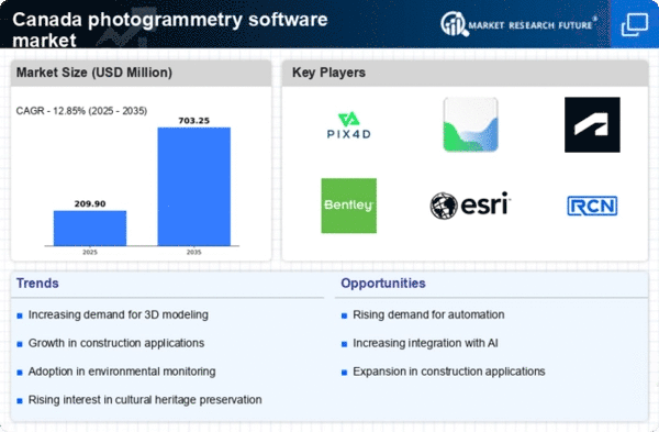
    Canada Photogrammetry Software Market Research Report- Forecast to 2035 Infographic
    Purchase Options
    $ 4,950.0
    $ 5,950.0
    $ 7,250.0

    Canada Photogrammetry Software Market Summary

    The Canada Photogrammetry Software market is poised for substantial growth, projected to reach 1738.9 million USD by 2035.

    Key Market Trends & Highlights

    Canada Photogrammetry Software Key Trends and Highlights

    • The market valuation for Canada Photogrammetry Software is estimated at 279 million USD in 2024.
    • By 2035, the market is expected to expand significantly to 1738.9 million USD.
    • The compound annual growth rate (CAGR) for the period from 2025 to 2035 is projected at 18.1 percent.
    • Growing adoption of photogrammetry technology due to increasing demand for accurate mapping and surveying is a major market driver.

    Market Size & Forecast

    2024 Market Size 279 (USD Million)
    2035 Market Size 1738.9 (USD Million)
    CAGR (2025-2035) 18.1%

    Major Players

    Hexagon AB, Autodesk, Esri, RealityCapture, DroneDeploy, GeoSLAM, Trimble, Bentley Systems, Pix4D

    Canada Photogrammetry Software Market Trends

    Numerous factors are driving prominent developments in the Canada photogrammetry software market. One of the main factors propelling this market is the growing need for precise mapping and modeling in industries like environmental monitoring, agriculture, and construction.

    Faster and more accurate data processing is now possible because to recent developments in software capabilities, such as automation and AI integration. These technical advancements address the demand for real-time data processing, which is crucial for a number of applications, including disaster response and traffic control in Canadian cities.

    Additionally, as farmers realize the advantages of using photogrammetry for crop monitoring and production projections, there is a huge opportunity in the agricultural industry, especially in precision farming.

    Canada is an attractive market for growth because it encourages technology-driven initiatives, which create an environment that is conducive to innovation and the use of photogrammetry software. All things considered, the patterns show a shift in the Canadian photogrammetry software market toward increased accuracy, efficiency, and environmental adaption.

    Market Segment Insights

    Canada Photogrammetry Software Market Segment Insights

    Canada Photogrammetry Software Market Segment Insights

    Photogrammetry Software Market Photogrammetry Type Insights

    Photogrammetry Software Market Photogrammetry Type Insights

    The Canada Photogrammetry Software Market has witnessed notable growth with advancements in technology and an increasing demand for precise data capture. This market primarily encompasses various types of photogrammetry, which are utilized across numerous sectors such as construction, agriculture, environmental monitoring, and urban planning.

    Aerial Photogrammetry stands out as a vital component of this segment, employing drones or aircraft to capture large areas quickly and efficiently, which makes it essential for spatial data acquisition in projects requiring extensive geographic coverage.Terrestrial Photogrammetry, on the other hand, focuses on capturing measurements from ground-based viewpoints, often used in surveying and architecture, providing accurate data in complex urban environments where aerial methods might be limited.

    In the context of Close-Range Photogrammetry, this technique involves using cameras positioned very near to the object of study, ideal for documenting small-sized objects or details in higher resolution, which is highly beneficial in fields like conservation and heritage documentation.

    Similarly, Satellite Photogrammetry has gained traction, leveraging satellite imagery for larger-scale mapping and environmental analysis, especially significant in monitoring deforestation and urban sprawl in Canada’s vast landscapes.Underwater Photogrammetry, though a niche area, holds importance for marine research and aquatic environmental monitoring, where it aids in mapping submerged structures or studying aquatic ecosystems.

    Photogrammetry Software Market Deployment Mode Insights

    Photogrammetry Software Market Deployment Mode Insights

    The Deployment Mode segment of the Canada Photogrammetry Software Market has shown notable growth, reflecting the evolving needs of industries that utilize photogrammetry for various applications, such as surveying, mapping, and construction.With businesses increasingly recognizing the value of technology, the market has seen a robust shift towards the adoption of cloud-based solutions, which offer flexibility, scalability, and cost-effectiveness.

    These cloud-based services enable real-time collaboration and data accessibility across different geographic locations, making them particularly attractive to companies engaged in project management and remote work scenarios.Conversely, the On-premises deployment remains significant for organizations that prioritize data security and control over their software environment, often preferred by sectors like government and defense due to stringent regulatory and privacy concerns.

    This dual approach of Deployment Mode allows stakeholders in the Canada Photogrammetry Software Market to tailor their software solutions to meet specific operational requirements, ensuring that they can capitalize on opportunities while addressing challenges related to data management and technology integration.As the industry evolves, advancements in both deployment modes are expected to drive further adoption and innovation within the market.

    Photogrammetry Software Market Pricing Model Insights

    Photogrammetry Software Market Pricing Model Insights

    The Canada Photogrammetry Software Market showcases a diverse Pricing Model segment that reflects varying needs and preferences within the industry. Commercial and Proprietary Software solutions are significant in the market, often favored for their advanced features, robust support, and regular updates, making them ideal for organizations needing consistent performance and reliability.

    This segment typically dominates the market due to the value-added services and technical assistance they provide, which are essential for large-scale projects in mapping and surveying. On the other hand, Open-Source Software has gained traction as an affordable alternative, allowing users to customize and adapt tools as per their specific requirements.

    It encourages innovation and collaboration, appealing especially to startups and academic institutions, which seek budget-friendly solutions. The balanced interplay between these two models illustrates a trend toward flexibility and accessibility in the Canada Photogrammetry Software Market.

    As technology continues to evolve, both segments are expected to adapt, responding to growing demands for efficiency and precision in various applications across sectors such as construction, environmental monitoring, and urban planning.

    Photogrammetry Software Market End Use Vertical Insights

    Photogrammetry Software Market End Use Vertical Insights

    The Canada Photogrammetry Software Market is significantly shaped by various end use verticals that drive demand for data collection and analysis tools, particularly in sectors such as Architecture, Engineering, and Construction (AEC). This segment plays a crucial role in enhancing design accuracy and project visualization.

    Surveying and Mapping have also emerged as vital applications, leveraging photogrammetry for detailed topographical data essential for urban planning and infrastructure development in Canada. Additionally, Mining and Natural Resources benefit considerably from photogrammetry, as it enables the efficient mapping and management of natural resources, which is significant given Canada's vast landscapes.

    The Oil and Gas sector utilizes this technology for pipeline monitoring and environmental assessments, ensuring compliance with stringent regulations. Agriculture and Forestry applications rely on photogrammetry for precision farming and forest management, minimizing resource wastage.

    Cultural Heritage and Archaeology make use of these tools for documenting and preserving historical sites with high fidelity. The Defense and Security segment utilizes photogrammetry for surveillance and reconnaissance, contributing to national safety. Moreover, Manufacturing and Industrial sectors employ photogrammetry for quality control and process optimization.

    Get more detailed insights about Canada Photogrammetry Software Market Research Report- Forecast to 2035

    Key Players and Competitive Insights

    The Canada Photogrammetry Software Market presents a dynamic landscape characterized by rapid advancements in technology and fierce competition among key players. Companies are increasingly focusing on developing innovative solutions that cater to a variety of applications such as surveying, mapping, and model generation.

    The market's competitiveness is driven by the growing demand for accurate data collection and analysis in various sectors, including construction, engineering, urban planning, and environmental monitoring. As organizations recognize the value of high-fidelity spatial information, they are seeking software solutions that can enhance their operational efficiency and project outcomes.

    Consequently, understanding the competitive landscape and recognizing the strengths of prominent players becomes critical for businesses aiming to thrive in this evolving market.

    Key Companies in the Canada Photogrammetry Software Market market include

    Industry Developments

    Growing Canadian interest in RealityCapture's high-performance photogrammetry solutions for facilitating 3D scanning, lidar integration, and digital twin generation was demonstrated in October 2023 at the GoGeomatics Expo in Calgary.

    Meanwhile, Pix4D was continuously cited as the preferred photogrammetry program for UAV image-to-3D conversion in surveying and agricultural workflows in Canadian drone mapping guidelines and evaluations throughout 2023–2024.

    Early in 2025, Canadian infrastructure engineering firms began using Bentley Systems' ContextCapture (now a part of iTwin Modeler) for high-resolution 3D mesh generation and feature recognition in digital twin projects. In February 2025, Canadian users on Reddit commended the product's clear output quality.

    A well-known Canadian consultant stated in February 2025 that ContextCapture was providing better model clarity than systems such as RealityCapture.

    To provide surveying, asset mapping, and infrastructure digitization services at scale, professional geospatial organizations in Canada rely on platforms such as Trimble, GeoSLAM, Autodesk ReCap Pro, Esri ArcGIS with integrated photogrammetry tools, and Hexagon AB.

    Market Segmentation

    Photogrammetry Software Market Pricing Model Outlook

    • Commercial/Proprietary Software
    • Open-Source Software

    Photogrammetry Software Market Deployment Mode Outlook

    • On-premises
    • Cloud-based

    Photogrammetry Software Market End Use Vertical Outlook

    • Architecture
    • Engineering
    • Construction (AEC)
    • Surveying and Mapping
    • Mining and Natural Resources
    • Oil and Gas
    • Agriculture and Forestry
    • Cultural Heritage and Archaeology
    • Defense and Security
    • Manufacturing and Industrial
    • Film
    • Animation
    • Gaming
    • Research And Education

    Photogrammetry Software Market Photogrammetry Type Outlook

    • Aerial Photogrammetry
    • Terrestrial Photogrammetry
    • Close-Range Photogrammetry
    • Satellite Photogrammetry
    • Underwater Photogrammetry
    • Others

    Report Scope


    Report Attribute/Metric Source: Details
    MARKET SIZE 2023 236.04(USD Million)
    MARKET SIZE 2024 279.0(USD Million)
    MARKET SIZE 2035 1738.92(USD Million)
    COMPOUND ANNUAL GROWTH RATE (CAGR) 18.098% (2025 - 2035)
    REPORT COVERAGE Revenue Forecast, Competitive Landscape, Growth Factors, and Trends
    BASE YEAR 2024
    MARKET FORECAST PERIOD 2025 - 2035
    HISTORICAL DATA 2019 - 2024
    MARKET FORECAST UNITS USD Million
    KEY COMPANIES PROFILED Vricon, Microdesk, Hexagon AB, Autodesk, OpenDroneMap, Esri, 3D Systems, Blue Marble Geographics, RealityCapture, DroneDeploy, GeoSLAM, Trimble, Bentley Systems, Pix4D
    SEGMENTS COVERED Photogrammetry Type, Deployment Mode, Pricing Model, End Use Vertical
    KEY MARKET OPPORTUNITIES Increased demand for 3D modeling, Growing drone technology adoption, Integration with GIS applications, Expansion in construction and surveying, Government initiatives for digital mapping
    KEY MARKET DYNAMICS growing demand from construction, advancements in drone technology, increasing use in surveying, integration with GIS platforms, rising adoption in agriculture
    COUNTRIES COVERED Canada

    FAQs

    What is the projected market size of the Canada Photogrammetry Software Market in 2024?

    The projected market size of the Canada Photogrammetry Software Market in 2024 is estimated to be 279.0 USD Million.

    What will the Canada Photogrammetry Software Market be valued at by 2035?

    By 2035, the Canada Photogrammetry Software Market is expected to be valued at approximately 1738.92 USD Million.

    What is the expected CAGR for the Canada Photogrammetry Software Market from 2025 to 2035?

    The expected CAGR for the Canada Photogrammetry Software Market from 2025 to 2035 is 18.098%.

    Which segment is expected to dominate the Canada Photogrammetry Software Market?

    Aerial Photogrammetry is projected to dominate the Canada Photogrammetry Software Market, anticipated to reach 490.0 USD Million by 2035.

    Which companies are the key players in the Canada Photogrammetry Software Market?

    Key players in the Canada Photogrammetry Software Market include Vricon, Microdesk, Hexagon AB, Autodesk, and Esri.

    What is the market size for Satellite Photogrammetry in 2024 and 2035?

    Satellite Photogrammetry is expected to have a market size of 70.0 USD Million in 2024 and 450.0 USD Million by 2035.

    How much is the Underwater Photogrammetry segment valued at in 2024?

    Underwater Photogrammetry is valued at 19.0 USD Million in 2024.

    What are the growth drivers for the Canada Photogrammetry Software Market?

    Growth drivers for the Canada Photogrammetry Software Market include increasing applications in surveying, mapping, and construction industries.

    What is the expected market size for Close-Range Photogrammetry by 2035?

    The expected market size for Close-Range Photogrammetry by 2035 is approximately 320.0 USD Million.

    What challenges does the Canada Photogrammetry Software Market face?

    The Canada Photogrammetry Software Market faces challenges including high initial investment and the need for skilled personnel.

    Report Infographic
    Free Sample Request

    Kindly complete the form below to receive a free sample of this Report

    Customer Stories

    “I am very pleased with how market segments have been defined in a relevant way for my purposes (such as "Portable Freezers & refrigerators" and "last-mile"). In general the report is well structured. Thanks very much for your efforts.”

    Victoria Milne Founder
    Case Study

    Chemicals and Materials