info@marketresearchfuture.com   📞  +1 (855) 661-4441(US)   📞  +44 1720 412 167(UK)
Certified Global Research Member
Isomar fd.webp Wcrc 57.webp
Key Questions Answered
  • Global Market Outlook
  • In-depth analysis of global and regional trends
  • Analyze and identify the major players in the market, their market share, key developments, etc.
  • To understand the capability of the major players based on products offered, financials, and strategies.
  • Identify disrupting products, companies, and trends.
  • To identify opportunities in the market.
  • Analyze the key challenges in the market.
  • Analyze the regional penetration of players, products, and services in the market.
  • Comparison of major players financial performance.
  • Evaluate strategies adopted by major players.
  • Recommendations
Why Choose Market Research Future?
  • Vigorous research methodologies for specific market.
  • Knowledge partners across the globe
  • Large network of partner consultants.
  • Ever-increasing/ Escalating data base with quarterly monitoring of various markets
  • Trusted by fortune 500 companies/startups/ universities/organizations
  • Large database of 5000+ markets reports.
  • Effective and prompt pre- and post-sales support.

Aerial Photogrammetry Software Market Research Report: By Application (Land Surveying, Construction, Mining, Agriculture, Environmental Monitoring), By Deployment Type (Cloud-Based, On-Premises), By End Use (Government, Commercial, Military, Research Institutions), By Software Type (2D Mapping Software, 3D Modeling Software, Data Processing Software) and By Regional (North America, Europe, South America, Asia Pacific, Middle East and Africa) - Forecast to 2032.


ID: MRFR/ICT/32536-HCR | 100 Pages | Author: Aarti Dhapte| November 2024

Aerial Photogrammetry Software Market Overview


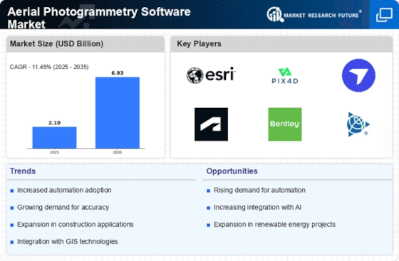
As per MRFR analysis, the Aerial Photogrammetry Software Market Size was estimated at 1.52 (USD Billion) in 2022. The Aerial Photogrammetry Software Market Industry is expected to grow from 1.7(USD Billion) in 2023 to 4.5 (USD Billion) by 2032. The Aerial Photogrammetry Software Market CAGR (growth rate) is expected to be around 11.45% during the forecast period (2024 - 2032).


Key Aerial Photogrammetry Software Market Trends Highlighted


The Aerial Photogrammetry Software Market is witnessing significant growth driven by the increasing demand for high-precision mapping and surveying across various industries. Key market drivers include advancements in drone technology, which enable quicker data collection and improved accuracy, and the expanding application of aerial imagery in urban planning, agriculture, and disaster management. These factors contribute to the rising adoption of photogrammetry solutions as organizations seek to enhance their operational efficiency and decision-making processes. Opportunities in this market are emerging from the integration of artificial intelligence and machine learning, which can automate data processing and analysis, making photogrammetry more accessible to smaller enterprises.

Additionally, the growing interest in smart cities and infrastructure development presents vast potential for enhancing aerial mapping capabilities. As organizations move towards greener, more sustainable practices, the demand for cost-effective aerial solutions over traditional surveying methods will likely increase. This evolving landscape allows companies to explore partnerships, collaborations, and innovations to cater to diverse customer needs. Trends in recent times also highlight the increasing use of cloud-based solutions for data storage and processing, enabling users to access and share data easily. The surge in remote work and collaboration tools promotes real-time data sharing and visualization among teams, driving growth in software applications.

Furthermore, the trend toward incorporating 3D modeling and virtual reality in photogrammetry can enhance visualization for various industries. As these trends continue to evolve, the market will likely see increased competition and innovation, paving the way for new entrants and established players alike to strengthen their offerings. The ongoing need for precise, efficient, and scalable solutions will guide the trajectory of the aerial photogrammetry software market in the years to come.


Aerial Photogrammetry Software Market Overview


Source: Primary Research, Secondary Research, MRFR Database and Analyst Review


Aerial Photogrammetry Software Market Drivers


Increased Demand for Geographic Information Systems (GIS)


The Aerial Photogrammetry Software Market Industry is witnessing a significant surge in demand for Geographic Information Systems (GIS), driven by the rising emphasis on spatial analytics and geographical data management. Organizations across various sectors, including urban planning, environmental monitoring, and disaster management, are increasingly leveraging aerial photogrammetry software to enhance their GIS capabilities. This software enables precise and detailed mapping of landscapes, facilitating better decision-making processes and resource allocation.

As cities continue to grow and the need for detailed geographic data escalates, the adoption of aerial photogrammetry solutions becomes indispensable. Furthermore, advancements in drone technology and satellite imagery are fueling the adoption of this software, allowing for more efficient and accurate data collection and analysis. The integration of aerial photogrammetry with GIS is also improving operational efficiencies and reducing the time required for data processing, ultimately driving the growth of the Aerial Photogrammetry Software Market Industry.

Consequently, as organizations strive for more effective ways to utilize geographical data, solutions that offer superior mapping accuracy and integrated functionalities are expected to see increased adoption.


Technological Advancements in Drone Technology


Technological advancements in drone technology represent a substantial driver for growth in the Aerial Photogrammetry Software Market Industry. With the evolution of drone capabilities, including better aerial surveillance, higher-resolution cameras, and advanced navigation systems, the application of aerial photogrammetry has become more efficient and widespread. Drones equipped with high-quality imaging technology can capture detailed images, which can be processed using photogrammetry software to create accurate 3D models and topographic maps.

This increased precision and the ability to gather data in challenging terrains are propelling industries like construction, agriculture, and environmental science to integrate aerial photogrammetry solutions into their workflows. Moreover, the reduction in operational costs due to diminished manpower requirements and the ability to gather data faster are compelling factors that are accelerating the demand for aerial photogrammetry software.


Growing Applications in Various Industries


The expansion of applications for aerial photogrammetry software across diverse industries is significantly contributing to the growth of the Aerial Photogrammetry Software Market Industry. Industries such as agriculture, mining, construction, and environmental management are increasingly recognizing the value of aerial photogrammetry in improving operational efficiency and data accuracy. For instance, in agriculture, farmers utilize aerial imagery to assess crop health, monitor soil conditions, and optimize resource allocation.

Similarly, in construction and engineering, aerial photogrammetry assists in undertaking site assessments, tracking progress, and ensuring compliance with regulations. This versatility in application helps to attract a broader customer base and promotes the integration of aerial photogrammetry solutions into existing workflows, stimulating further innovation and growth within the market.


Aerial Photogrammetry Software Market Segment Insights


Aerial Photogrammetry Software Market Application Insights


The Aerial Photogrammetry Software Market, specifically focusing on the Application segment, showcases a robust growth trajectory, contributing significantly to the overall valuation of the market. In 2023, the total market is set at 1.7 USD Billion and is expected to experience substantial growth by 2032. Within this Application segment, key areas include Land Surveying, Construction, Mining, Agriculture, and Environmental Monitoring, each contributing uniquely to the Aerial Photogrammetry Software Market revenue. Among these, Land Surveying holds a majority share, valued at 0.504 USD Billion in 2023 and projected to rise to 1.26 USD Billion by 2032, underscoring its critical role in infrastructure development and resource management.

Construction follows with a valuation of 0.315 USD Billion in 2023, showing its importance in project visualization and site management, aiming for a growth to 0.9 USD Billion by 2032. Mining, while smaller, represents a targeted application of aerial software, valued at 0.189 USD Billion in 2023 and forecasted to expand to 0.48 USD Billion by 2032, indicating a growing focus on optimizing resource extraction and site monitoring. Agriculture is also a significant player, valued at 0.378 USD Billion in 2023, projected to grow to 0.96 USD Billion by 2032, highlighting its utility in precision farming and monitoring crop health.

Lastly, Environmental Monitoring stands at a strong value of 0.315 USD Billion in 2023, anticipated to reach 0.9 USD Billion by 2032, reflecting the increasing demand for data in climate studies and land-use planning. The growth in these segments is driven by technological advancements, regulatory supportive frameworks, and the rising demand for accurate data in a broad range of industries. However, challenges such as high initial investment and the need for skilled personnel may impede broader adoption. The Aerial Photogrammetry Software Market Statistics indicate a strong upward trend across all applications within this market segment, emphasizing the transformative impact these technologies have across sectors like construction, agriculture, and environmental management.

As industries continue to recognize the value of aerial photogrammetry in enhancing operational efficiency and decision-making processes, opportunities abound within the space, shaping the Landscape of the Aerial Photogrammetry Software Market industry in the years ahead.


Aerial Photogrammetry Software Market Type Insights


Source: Primary Research, Secondary Research, MRFR Database and Analyst Review


Aerial Photogrammetry Software Market Deployment Type Insights


The Aerial Photogrammetry Software Market, valued at 1.7 USD Billion in 2023, is experiencing notable growth, particularly in its Deployment Type segment, which includes Cloud-Based and On-Premises solutions. Among these, Cloud-Based deployment has gained a significant traction due to its scalability, ease of access, and cost-effectiveness, making it an attractive choice for businesses looking to streamline their operations. On the other hand, On-Premises solutions maintain a strong market presence, appealing to organizations that prioritize data security and control over their information.


As businesses increasingly seek efficient and innovative ways to capture aerial data, the ongoing investment in cloud technologies is expected to play a crucial role in shaping the future landscape of the Aerial Photogrammetry Software Market. This market growth is bolstered by trends such as the rising demand for high-resolution imagery and advancements in drone technology, while challenges include the need for skill development and concerns over data privacy. Overall, the insights reveal a healthy anticipated trajectory for the Aerial Photogrammetry Software Market as it adapts to evolving industry needs.


Aerial Photogrammetry Software Market End-Use Insights


In 2023, the Aerial Photogrammetry Software Market is valued at 1.7 billion USD, reflecting its growing relevance across various End Use sectors. The market growth is propelled by increasing applications in Government, where aerial imaging supports urban planning and infrastructure development. The Commercial sector showcases significant utilization, driven by the construction, real estate, and agriculture industries relying on drones to gather accurate data efficiently. In the Military domain, robust demand arises from the need for advanced reconnaissance and surveillance capabilities, enabling strategic decision-making.

Research Institutions also play a vital role, as they leverage aerial photogrammetry for environmental studies and geographical analysis. The rising need for precise mapping and data analytics across these segments supports the overall market growth, showcasing a consistent growth trajectory characterized by evolving technological advancements and increasing investments. The diverse applications across various sectors indicate strong potential for ongoing development and innovative solutions within the Aerial Photogrammetry Software Market industry.


Aerial Photogrammetry Software Market Software Type Insights


The Aerial Photogrammetry Software Market revenue in 2023 reached 1.7 billion USD, reflecting robust growth in software solutions utilized for mapping and modeling purposes. The market segmentation reveals distinct categories, highlighting the importance of tools like 2D Mapping Software, which has become essential for urban planning and land-use analysis due to its simplicity and effectiveness. On the other hand, 3D Modeling Software is significant as it enables detailed visualizations and simulations, increasingly gaining traction in industries such as construction and film production.

Additionally, Data Processing Software plays a crucial role in the analysis and management of vast data collected from aerial surveys, ensuring efficiency in extracting valuable insights. The growth drivers within this market include advancements in drone technology and the increasing demand for geographical information systems, contributing to a projected increase in overall market valuation to 4.5 billion USD by 2032. However, the market also faces challenges like the high cost of software solutions and regulatory hurdles affecting the adoption of aerial technologies.

Nonetheless, emerging opportunities for innovation and integration with AI technology present a promising future for the Aerial Photogrammetry Software Market industry.


Aerial Photogrammetry Software Market Regional Insights


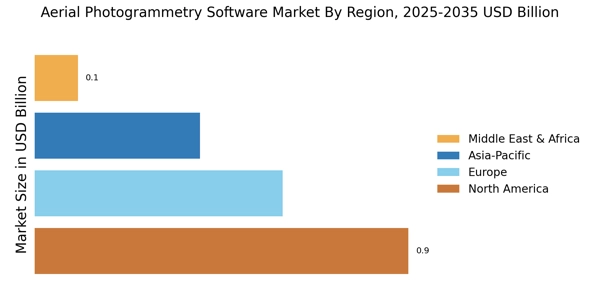
The Aerial Photogrammetry Software Market exhibits a dynamic landscape across various regions, driven by increasing demand for advanced mapping technologies and drone applications. In 2023, the North America region holds a majority share, with a valuation of 0.72 USD Billion, reflecting its strong technological infrastructure and innovation appetite, which is expected to grow to 1.98 USD Billion by 2032. Europe follows closely with a valuation of 0.51 USD Billion in 2023, rising to 1.36 USD Billion, highlighting its significant investments in urban planning and environmental monitoring.

The APAC region, valued at 0.35 USD Billion initially, is projected to reach 0.9 USD Billion, driven by rapid infrastructure development and government initiatives in emerging economies. South America and MEA are smaller segments, valued at 0.07 USD Billion and 0.05 USD Billion, respectively, but they present growth opportunities, particularly in resource management and regional mapping, expectantly increasing to 0.17 USD Billion and 0.09 USD Billion by 2032. Overall, the diverse requirements and applications across these regions contribute to an evolving landscape within the Aerial Photogrammetry Software Market, shaping future market growth and opportunities.


Aerial Photogrammetry Software Market Regional Insights


Source: Primary Research, Secondary Research, MRFR Database and Analyst Review


Aerial Photogrammetry Software Market Key Players and Competitive Insights


The Aerial Photogrammetry Software Market is characterized by rapid advancements in technology and increasing demand across various industries, such as construction, agriculture, and environmental monitoring. Competitive insights into this market reveal a landscape populated by both established and emerging players, all vying for innovation and market share. Companies are focusing on enhancing their product offerings with cutting-edge features like 3D mapping, real-time data processing, and cloud-based solutions. Collaboration and mergers are on the rise as companies aim to consolidate resources and expertise to meet the growing needs of users. Factors like customer service, pricing models, and specialized applications are also key differentiators in market positioning, driving companies to develop tailored solutions that address specific sector requirements.

Atlassian has carved a significant niche within the Aerial Photogrammetry Software Market, showcasing a robust ability to integrate collaborative tools and project management capabilities into its software offerings. This enables teams to work seamlessly on complex projects that involve aerial data capture and analysis. The strength of Atlassian lies in its commitment to user-centric design, offering intuitive interfaces that enhance user experience and make complex tasks more manageable. Additionally, their software solutions are designed to be highly customizable, allowing organizations to tailor functionalities to their unique operational workflows. The company's established brand reputation and extensive support network provide added assurance to users, contributing to its competitive advantage in a rapidly evolving market.

Trimble stands out in the Aerial Photogrammetry Software Market, with a strong emphasis on precision and accuracy in mapping and measurement solutions. The company's suite of software tools is renowned for its ability to integrate data from various sources, including drones, aerial imagery, and traditional surveying methods. This comprehensive data fusion results in highly accurate and reliable outputs, essential for applications in construction and land management. Trimble's focus on innovation is evident in its continuous investment in research and development, allowing it to stay ahead of emerging trends and technologies in photogrammetry. Furthermore, Trimble's extensive industry partnerships enhance its market presence, enabling the company to leverage shared expertise and provide robust, end-to-end solutions that meet diverse client needs in the aerial photogrammetry space.


Key Companies in the Aerial Photogrammetry Software Market Include:


  • Atlassian


  • Trimble


  • Esri


  • C3S


  • SenseFly


  • 3D Robotics


  • Autodesk


  • Microsoft


  • DroneDeploy


  • PARCA


  • Pix4D


  • GeoSLAM


  • Bentley Systems


Aerial Photogrammetry Software Market Industry Developments


Recent developments in the Aerial Photogrammetry Software Market have been marked by increased investments and advancements in technology. Companies such as Esri and Autodesk continue to innovate with enhanced mapping tools and integration capabilities for drone data processing, catering to the rising demand in sectors like construction and agriculture. Trimble has also expanded its offerings by integrating AI and machine learning for more accurate terrain modeling.

The landscape has seen significant mergers and acquisitions, with DroneDeploy acquiring a smaller analytics firm to bolster its capabilities in processing aerial data efficiently, while Pix4D has partnered with several drone manufacturers to enhance software compatibility, underscoring the trend towards collaborative efforts in the market.


Economic growth in this sector is being fueled by the increasing adoption of drones for surveying and mapping, particularly in developing markets, which is propelling the market valuation of key players like Bentley Systems and GeoSLAM. These developments are indicative of a rapidly evolving market where technology and collaboration are driving improvements in aerial photogrammetry applications across various industries.


Aerial Photogrammetry Software Market Segmentation Insights


  1. Aerial Photogrammetry Software Market Application Outlook


    1. Land Surveying


    2. Construction


    3. Mining


    4. Agriculture


    5. Environmental Monitoring


  1. Aerial Photogrammetry Software Market Deployment Type Outlook


    1. Cloud-Based


    2. On-Premises


  1. Aerial Photogrammetry Software Market End Use Outlook


    1. Government


    2. Commercial


    3. Military


    4. Research Institutions


  1. Aerial Photogrammetry Software Market Software Type Outlook


    1. 2D Mapping Software


    2. 3D Modeling Software


    3. Data Processing Software


  1. Aerial Photogrammetry Software Market Regional Outlook


    1. North America


    2. Europe


    3. South America


    4. Asia Pacific


    5. Middle East and Africa


Report Attribute/Metric Details
Market Size 2022 1.52(USD Billion)
Market Size 2023 1.7(USD Billion)
Market Size 2032 4.5(USD Billion)
Compound Annual Growth Rate (CAGR) 11.45% (2024 - 2032)
Report Coverage Revenue Forecast, Competitive Landscape, Growth Factors, and Trends
Base Year 2023
Market Forecast Period 2024 - 2032
Historical Data 2019 - 2023
Market Forecast Units USD Billion
Key Companies Profiled Atlassian, Trimble, Esri, C3S, SenseFly, 3D Robotics, Autodesk, Microsof, DroneDeploy, PARCA, Pix4D, GeoSLAM, Bentley Systems
Segments Covered Application, Deployment Type, End Use, Software Type, Regional
Key Market Opportunities Rise in drone adoption, Increasing demand for geospatial data, Advancements in AI integration, Growing need for 3D mapping, Expanding applications in construction.
Key Market Dynamics Technological advancements, Increasing demand for mapping, Rising adoption in construction, Growing interest in aerial surveys, Regulatory compliance and safety standards
Countries Covered North America, Europe, APAC, South America, MEA


Frequently Asked Questions (FAQ) :

The Aerial Photogrammetry Software Market is expected to be valued at 4.5 USD Billion by 2032.

The expected CAGR for the Aerial Photogrammetry Software Market is 11.45% from 2024 to 2032.

North America is projected to have the largest market share, valued at 1.98 USD Billion by 2032.

The market size for the Land Surveying application is expected to reach 1.26 USD Billion by 2032.

Key players in the market include Atlassian, Trimble, Esri, C3S, SenseFly, and 3D Robotics.

The market size for the Agriculture application is expected to be 0.96 USD Billion by 2032.

The Environmental Monitoring application market size is projected to be 0.9 USD Billion by 2032.

The expected market value for the Construction application in 2023 is 0.315 USD Billion.

The Mining application's market value is expected to grow from 0.189 USD Billion in 2023 to 0.48 USD Billion by 2032.

The market in South America is expected to grow to 0.17 USD Billion by 2032.

Leading companies partner with us for data-driven Insights
client_1 client_2 client_3 client_4 client_5 client_6 client_7 client_8 client_9 client_10
Kindly complete the form below to receive a free sample of this Report
Please fill in Business Email for Quick Response

We do not share your information with anyone. However, we may send you emails based on your report interest from time to time. You may contact us at any time to opt-out.

Purchase Option
Single User $ 4,950
Multiuser License $ 5,950
Enterprise User $ 7,250
Compare Licenses
Tailored for You
  • Dedicated Research on any specifics segment or region.
  • Focused Research on specific players in the market.
  • Custom Report based only on your requirements.
  • Flexibility to add or subtract any chapter in the study.
  • Historic data from 2014 and forecasts outlook till 2040.
  • Flexibility of providing data/insights in formats (PDF, PPT, Excel).
  • Provide cross segmentation in applicable scenario/markets.