• Cat-intel
  • MedIntelliX
  • Resources
  • About Us
  • Request Free Sample ×

    Kindly complete the form below to receive a free sample of this Report

    Leading companies partner with us for data-driven Insights

    clients tt-cursor

    Japan Photogrammetry Software Market

    ID: MRFR/ICT/60062-HCR
    200 Pages
    Aarti Dhapte
    September 2025

    Japan Photogrammetry Software Market Research Report By Photogrammetry Type (Aerial Photogrammetry, Terrestrial Photogrammetry, Close-Range Photogrammetry, Satellite Photogrammetry, Underwater Photogrammetry, Others), By Deployment Mode (On-premises, Cloud-based), By Pricing Model (Commercial/Proprietary Software, Open-Source Software), and By End Use Vertical (Architecture, Engineering, Construction (AEC), Surveying and Mapping, Mining and Natural Resources, Oil and Gas, Agriculture and Forestry, Cultural Heritage and Archaeology, Defense a...

    Share:
    Download PDF ×

    We do not share your information with anyone. However, we may send you emails based on your report interest from time to time. You may contact us at any time to opt-out.

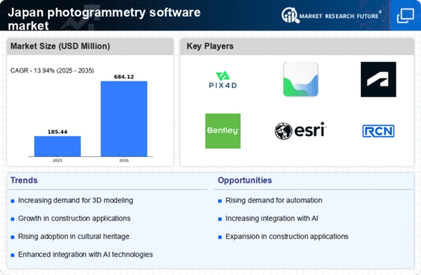
    Japan Photogrammetry Software Market Research Report- Forecast to 2035 Infographic
    Purchase Options
    $ 4,950.0
    $ 5,950.0
    $ 7,250.0

    Japan Photogrammetry Software Market Summary

    The Japan Photogrammetry Software market is projected to experience substantial growth from 139.5 million USD in 2024 to 669 million USD by 2035.

    Key Market Trends & Highlights

    Japan Photogrammetry Software Key Trends and Highlights

    • The market is expected to grow at a compound annual growth rate (CAGR) of 15.32% from 2025 to 2035.
    • By 2035, the market valuation is anticipated to reach 669 million USD, indicating robust demand for photogrammetry solutions.
    • In 2024, the market is valued at 139.5 million USD, reflecting a strong foundation for future expansion.
    • Growing adoption of advanced imaging technologies due to increasing demand for accurate data capture is a major market driver.

    Market Size & Forecast

    2024 Market Size 139.5 (USD Million)
    2035 Market Size 669 (USD Million)
    CAGR (2025-2035) 15.32%

    Major Players

    Topcon, Pix4D, DroneDeploy, Hexagon AB, Trimble, RealityCapture, Autodesk, Esri, Bentley Systems, Agisoft

    Japan Photogrammetry Software Market Trends

    The market for photogrammetry software in Japan is expanding significantly due to a number of important factors, including the need for accurate data collecting in a variety of industries and technical improvements. Aerial mapping skills have been improved in Japan by the rise of drones and UAV technology, enabling more precise and effective data collection.

    Additionally, photogrammetry software is being used more and more in industries like urban planning, agriculture, and construction to produce 3D models and geographical information systems (GIS) that improve project management and decision-making.There are increasing opportunities in this sector, especially for businesses that can combine photogrammetry with other technologies like machine learning and artificial intelligence. Organizations can increase operational efficiency and reduce costs by utilizing these advances to automate workflows and speed up data processing.

    As part of its larger objective to encourage the development of smart cities, the Japanese government is also encouraging innovation in this area, which offers a potential environment for photogrammetry applications in infrastructure planning and development.

    Recent trends show a move toward cloud-based photogrammetry technologies, which facilitate data access and cooperation across several platforms. This strategy fits with Japan's growing emphasis on digital transformation in all sectors as businesses look for methods to increase output and simplify procedures.

    Furthermore, the emergence of smart agriculture efforts in Japan emphasizes how important photogrammetry software is for crop health monitoring and agricultural operations optimization. All things considered, these trends suggest that Japan's photogrammetry software business is strong and developing, with many opportunities for expansion and innovation.

    Market Segment Insights

    Japan Photogrammetry Software Market Segment Insights

    Japan Photogrammetry Software Market Segment Insights

    Photogrammetry Software Market Photogrammetry Type Insights

    Photogrammetry Software Market Photogrammetry Type Insights

    The Japan Photogrammetry Software Market is experiencing significant growth, driven by increasing demands across various applications, leading to a comprehensive landscape characterized by diverse types of photogrammetry techniques.Photogrammetry Type in this market includes Aerial Photogrammetry, Terrestrial Photogrammetry, Close-Range Photogrammetry, Satellite Photogrammetry, Underwater Photogrammetry, and Other methodologies.

    Aerial Photogrammetry holds considerable importance, particularly in planning and environmental monitoring, as it provides detailed topographic data and enables efficient land-use planning. Terrestrial Photogrammetry, on the other hand, is critical in construction and civil engineering, facilitating precision in measurements and contributing to enhanced project outcomes.

    Close-Range Photogrammetry finds its application in cultural heritage documentation and industrial design, allowing for detailed surface modeling of small objects. Satellite Photogrammetry leverages space-based assets to gather extensive geographic data, playing a vital role in climate studies and disaster management in Japan, which is prone to natural hazards.

    The Underwater Photogrammetry segment offers specialized capabilities for marine exploration and marine construction, highlighting the region’s extensive maritime interests and research needs. The Other category encompasses niche applications such as drone-based photogrammetry and virtual reality, showcasing innovative trends within the industry.

    As the market expands, the insights derived from these various segmentations will inform and guide strategic decisions across sectors, supporting Japan's objectives in urban planning, environmental sustainability, heritage conservation, and more.The convergence of traditional photogrammetry practices with modern digital technology is likely to drive innovation further, impacting how geographical and spatial data is utilized across industries, making it crucial to monitor emerging trends and adapt to evolving market needs.

    Source: Primary Research, Secondary Research, Market Research Future Database and Analyst Review

    Photogrammetry Software Market Deployment Mode Insights

    Photogrammetry Software Market Deployment Mode Insights

    The Japan Photogrammetry Software Market shows a significant focus on the Deployment Mode segment, which encompasses On-premises and Cloud-based solutions. On-premises deployment remains appealing to many industries, particularly where data security and control are critical, such as in government and construction sectors, ensuring compliance with stringent regulations.

    This mode allows organizations to customize installations to meet specific needs and integrate with existing infrastructure. Conversely, the Cloud-based deployment is gaining traction due to its scalability, lower upfront costs, and the convenience of remote access.As organizations in Japan increasingly seek efficient solutions, the demand for Cloud-based photogrammetry software is anticipated to grow, driven by benefits such as ease of collaboration and enhanced data sharing capabilities.

    This shift reflects broader trends toward digital transformation across various industry sectors, providing ample opportunities for innovation in Japan's photogrammetry landscape.Together, these deployment modes cater to diverse user requirements and significantly influence the overall growth trajectory of the Japan Photogrammetry Software Market, which is expanding in response to technological advancements and evolving market needs.

    Photogrammetry Software Market Pricing Model Insights

    Photogrammetry Software Market Pricing Model Insights

    The Pricing Model segment of the Japan Photogrammetry Software Market showcases a diverse landscape influenced by the dichotomy between Commercial/Proprietary Software and Open-Source Software.Commercial software often captures a majority of the market share, driven by its robust features, dedicated support, and regular updates, appealing to businesses that prioritize reliability and comprehensive functionality.

    In contrast, Open-Source Software is gaining traction, particularly among startups and educational institutions, due to its flexibility, customization options, and no-cost access, facilitating innovation and rapid prototyping among developers. The increasing demand for accurate and efficient mapping solutions in various sectors such as construction, agriculture, and urban planning fuels growth in both categories.

    As Japan aims to enhance its technological infrastructure and advance automation in industries, the significance of these pricing models becomes more pronounced, leading to ongoing investments in software that can meet the evolving needs of users while addressing challenges related to scalability and integration with existing systems.Overall, the market reflects a blend of traditional and modern approaches to software adoption, influenced by user preferences and technological advancements.

    Photogrammetry Software Market End Use Vertical Insights

    Photogrammetry Software Market End Use Vertical Insights

    The Japan Photogrammetry Software Market showcases a diverse range of applications across various end use verticals, emphasizing its importance in driving technological advancements and operational efficiencies. In the Architecture, Engineering, and Construction (AEC) sector, photogrammetry facilitates accurate modeling and visualization, influencing project workflows and reducing costs.

    Surveying and Mapping rely heavily on this technology for precision in data collection, significantly enhancing geographic data accuracy. Industries like Mining and Natural Resources utilize photogrammetry for efficient resource identification and environmental monitoring, while the Oil and Gas sector benefits from aerial surveys to assess pipeline routes and field surveys.

    Additionally, Agriculture and Forestry sectors leverage photogrammetry for land management and crop monitoring, illustrating its applicability in sustainable practices. Cultural Heritage and Archaeology employ this technology for documentation and preservation, ensuring historical sites are accurately recorded.

    The Defense and Security domain recognizes photogrammetry's value in surveillance and reconnaissance. Manufacturing and Industrial applications also see improvements in productivity through enhanced spatial awareness. Lastly, Film, Animation, and Gaming utilize photogrammetry for realistic graphics and scenery, enriching user experience.

    Get more detailed insights about Japan Photogrammetry Software Market Research Report- Forecast to 2035

    Key Players and Competitive Insights

    The competitive landscape of the Japan Photogrammetry Software Market is characterized by rapid technological advancements and a growing demand for precision in surveying, mapping, and construction applications. Various stakeholders, including software developers, hardware manufacturers, and professional service providers, are vying for market share in this dynamic environment.

    The sector is influenced by factors such as rising investments in research and development, increased adoption of drones for data collection, and the need for efficient data integration across multiple platforms. Companies in this market are focusing on enhancing user experience, improving processing speeds, and offering customizable solutions tailored to meet specific industry needs.

    Topcon has established a robust presence in the Japan Photogrammetry Software Market, capitalizing on its extensive portfolio of geospatial solutions. The company is known for its cutting-edge technologies and focus on precision that meets the rigorous demands of surveying and construction professionals.

    Topcon's strengths lie in its strong brand reputation, customer-centric approach, and the seamless integration of its software with hardware offerings. The company's solutions are designed to optimize workflows, thus providing users with significant efficiency gains.

    As a pioneer in the field, Topcon has maintained a competitive edge through continuous innovation and strong partnerships with various industries across Japan, enabling it to reinforce its standing within this specialized market.Pix4D is another significant player in the Japan Photogrammetry Software Market, renowned for its advanced photogrammetry software solutions that cater to various applications, including agriculture, construction, and mining.

    The company has established a strong market presence, largely due to its user-friendly software, which empowers users to capture and process aerial imagery with remarkable accuracy. Pix4D’s strengths include its commitment to research and innovation, responsive customer support, and a wide range of key products and services that address diverse client needs.

    In terms of expansion, Pix4D has focused on strategic partnerships and collaborations within Japan to enhance its market reach. The company’s ongoing developments and potential mergers or acquisitions could further solidify its competitive position, as it continues to adapt to the evolving demands of the Japanese market.

    Key Companies in the Japan Photogrammetry Software Market market include

    Industry Developments

    The introduction of free licensing for businesses making less than $1 million USD by RealityCapture, a division of Epic Games, in April 2024 has increased usage among Japanese small studios, universities, and SMEs looking to create high-resolution 3D meshes without having to worry about license costs.

    Pix4D consolidated user support in local surveying, agriculture, inspection, and disaster-preparedness processes in July 2023 by establishing a Tokyo office in Shibuya and publishing technical documentation and use cases in Japanese.

    While more recent Japanese releases have expanded on this approach after 2017, Pix4D's collaboration with Kokusai Kogyo Corporation continues to be essential to supporting Japan's i-Construction strategy by providing automated drone mapping for government and infrastructure applications that complies with public surveys.

    For terrain modeling and GIS-integrated photogrammetry, Japanese engineering and mapping companies continued to use Autodesk ReCap, Esri ArcGIS, Trimble, and Hexagon/Leica platforms in 2023–2025. ContextCapture from Bentley was used in digital twin projects involving airports and major infrastructure in Japan.

    Informal user input from Japanese UAV pilot forums reflects a worldwide trend: DroneDeploy, RealityCapture, and Pix4D are frequently mentioned as preferable tools. Pix4D is regarded for its accuracy and compliance with government regulations, while RealityCapture is recognized for its speed and free license.

    All of these advancements highlight the fact that by mid-2025, the most well-known and frequently utilized photogrammetry systems in Japan will be Pix4D, RealityCapture, Topcon, Hexagon, Trimble, Autodesk, Esri, Bentley, and Agisoft.

    Market Segmentation

    Photogrammetry Software Market Pricing Model Outlook

    • Commercial/Proprietary Software
    • Open-Source Software

    Photogrammetry Software Market Deployment Mode Outlook

    • On-premises
    • Cloud-based

    Photogrammetry Software Market End Use Vertical Outlook

    • Architecture
    • Engineering
    • Construction (AEC)
    • Surveying and Mapping
    • Mining and Natural Resources
    • Oil and Gas
    • Agriculture and Forestry
    • Cultural Heritage and Archaeology
    • Defense and Security
    • Manufacturing and Industrial
    • Film
    • Animation
    • Gaming
    • Research And Education

    Photogrammetry Software Market Photogrammetry Type Outlook

    • Aerial Photogrammetry
    • Terrestrial Photogrammetry
    • Close-Range Photogrammetry
    • Satellite Photogrammetry
    • Underwater Photogrammetry
    • Others

    Report Scope


    Report Attribute/Metric Source: Details
    MARKET SIZE 2023 118.02(USD Million)
    MARKET SIZE 2024 139.5(USD Million)
    MARKET SIZE 2035 669.0(USD Million)
    COMPOUND ANNUAL GROWTH RATE (CAGR) 15.318% (2025 - 2035)
    REPORT COVERAGE Revenue Forecast, Competitive Landscape, Growth Factors, and Trends
    BASE YEAR 2024
    MARKET FORECAST PERIOD 2025 - 2035
    HISTORICAL DATA 2019 - 2024
    MARKET FORECAST UNITS USD Million
    KEY COMPANIES PROFILED Topcon, Pix4D, 3D Survey, DroneDeploy, LiDAR USA, Hexagon AB, Trimble, RealityCapture, Autodesk, Esri, Skycatch, PhotoModeler Technologies, Bentley Systems, Agisoft
    SEGMENTS COVERED Photogrammetry Type, Deployment Mode, Pricing Model, End Use Vertical
    KEY MARKET OPPORTUNITIES Rising demand in construction projects, Advancements in drone technology, Increased adoption in urban planning, Growth in cultural heritage preservation, Expansion of GIS applications
    KEY MARKET DYNAMICS technological advancements, increasing demand for automation, growing applications in engineering, rising adoption in construction, enhanced data accuracy requirements
    COUNTRIES COVERED Japan

    FAQs

    What is the expected market size of the Japan Photogrammetry Software Market in 2024?

    The Japan Photogrammetry Software Market is expected to be valued at 139.5 million USD in 2024.

    What is the projected market size for the Japan Photogrammetry Software Market in 2035?

    By 2035, the Japan Photogrammetry Software Market is projected to reach a value of 669.0 million USD.

    What is the expected compound annual growth rate (CAGR) for the Japan Photogrammetry Software Market from 2025 to 2035?

    The market is anticipated to grow at a CAGR of 15.318% during the period from 2025 to 2035.

    Which segments are expected to dominate the market in terms of value in 2024?

    In 2024, Terrestrial Photogrammetry is expected to lead with a value of 35.0 million USD, followed by Aerial Photogrammetry at 30.0 million USD.

    What are the expected values for Aerial Photogrammetry and Terrestrial Photogrammetry in 2035?

    By 2035, Aerial Photogrammetry is projected to be valued at 145.0 million USD, while Terrestrial Photogrammetry is expected to reach 170.0 million USD.

    Who are the key players in the Japan Photogrammetry Software Market?

    Major players in the market include Topcon, Pix4D, DroneDeploy, Trimble, and Autodesk.

    What value is Underwater Photogrammetry expected to reach by 2035?

    Underwater Photogrammetry is expected to grow to 144.0 million USD by 2035.

    What are the key growth drivers for the Japan Photogrammetry Software Market?

    Key growth drivers include advancements in drone technology and increased applications in surveying and mapping.

    What challenges might affect the growth of the Japan Photogrammetry Software Market?

    Challenges may include regulatory hurdles related to drone usage and data privacy concerns.

    What impact could emerging trends have on the market through 2035?

    Emerging trends, such as the integration of artificial intelligence, are expected to enhance efficiency and expand applications across various sectors.

    Report Infographic
    Free Sample Request

    Kindly complete the form below to receive a free sample of this Report

    Customer Stories

    “I am very pleased with how market segments have been defined in a relevant way for my purposes (such as "Portable Freezers & refrigerators" and "last-mile"). In general the report is well structured. Thanks very much for your efforts.”

    Victoria Milne Founder
    Case Study

    Chemicals and Materials