Adoption of Smart City Initiatives
The Terrestrial Photogrammetry Software Market is significantly influenced by the global trend towards smart city initiatives. As urban areas strive to enhance infrastructure and service delivery, the demand for accurate spatial data becomes paramount. Photogrammetry software plays a crucial role in urban planning, enabling city planners to visualize and analyze spatial relationships effectively. The increasing investment in smart city projects, estimated to reach over 1 trillion dollars by 2030, underscores the importance of advanced mapping technologies. This trend not only drives the adoption of terrestrial photogrammetry software but also encourages collaboration among various stakeholders, including government agencies and private enterprises, to create integrated solutions that address urban challenges.
Advancements in Data Processing Technologies
The Terrestrial Photogrammetry Software Market is benefiting from rapid advancements in data processing technologies. Innovations in computing power and algorithms have enhanced the efficiency and accuracy of photogrammetric data processing. As a result, users can now generate high-quality 3D models and maps more quickly than ever before. The integration of cloud computing solutions further streamlines data storage and accessibility, allowing for real-time collaboration among users. This technological evolution is likely to attract a broader range of industries to adopt terrestrial photogrammetry software, as it becomes increasingly feasible to process large datasets efficiently. Consequently, the market is expected to witness a notable increase in adoption rates, driven by these technological improvements.
Increasing Demand for Accurate Mapping Solutions
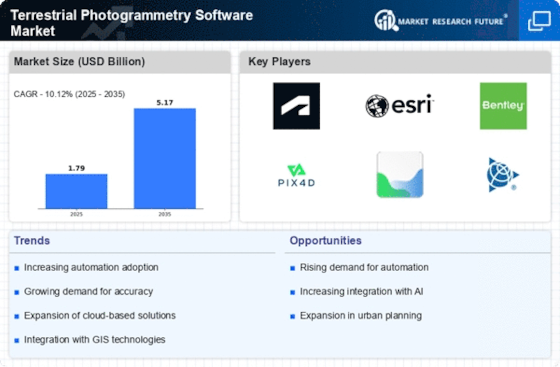
The Terrestrial Photogrammetry Software Market is experiencing a surge in demand for precise mapping solutions across various sectors, including construction, agriculture, and urban planning. As industries increasingly rely on accurate geographical data for decision-making, the need for advanced photogrammetry software becomes evident. The market is projected to grow at a compound annual growth rate (CAGR) of approximately 12% over the next five years, driven by the necessity for high-resolution mapping and modeling. This growth is further fueled by the integration of advanced technologies, such as drones and 3D scanning, which enhance the capabilities of terrestrial photogrammetry software. Consequently, businesses are investing in these solutions to improve operational efficiency and reduce costs, indicating a robust trajectory for the industry.
Growth in Environmental Monitoring and Management
The Terrestrial Photogrammetry Software Market is poised for growth due to the rising emphasis on environmental monitoring and management. As concerns about climate change and natural resource depletion intensify, organizations are increasingly utilizing photogrammetry software to assess and manage environmental impacts. This software enables the collection of detailed spatial data, facilitating the monitoring of land use changes, vegetation health, and natural disaster impacts. The market for environmental monitoring solutions is expected to expand significantly, with projections indicating a growth rate of around 10% annually. This trend highlights the critical role of terrestrial photogrammetry software in supporting sustainable practices and informed decision-making in environmental management.
Rising Popularity of Augmented Reality Applications
The Terrestrial Photogrammetry Software Market is experiencing a notable impact from the rising popularity of augmented reality (AR) applications. As industries such as real estate, gaming, and education explore the potential of AR, the demand for accurate 3D models generated through photogrammetry is on the rise. These applications require precise spatial data to create immersive experiences, thereby driving the need for advanced terrestrial photogrammetry software. The market for AR is projected to grow significantly, with estimates suggesting a value of over 200 billion dollars by 2025. This trend indicates a promising opportunity for photogrammetry software providers to cater to the evolving needs of various sectors, ultimately contributing to the expansion of the industry.


