• Cat-intel
  • MedIntelliX
  • Resources
  • About Us
  • Request Free Sample ×

    Kindly complete the form below to receive a free sample of this Report

    Leading companies partner with us for data-driven Insights

    clients tt-cursor
    Hero Background

    UAV LiDAR Market

    ID: MRFR/A&D/4795-HCR
    137 Pages
    Sejal Akre
    October 2025

    UAV LiDAR Market Research Report By Application (Surveying, Mapping, Agriculture, Forestry, Infrastructure), By Platform Type (Fixed-Wing UAV, Rotary-Wing UAV, Hybrid UAV), By End Use (Government, Commercial, Defense, Research), By Technology (Airborne LiDAR, Terrestrial LiDAR) and By Regional (North America, Europe, South America, Asia Pacific, Middle East and Africa) - Forecast to 2032

    Share:
    Download PDF ×

    We do not share your information with anyone. However, we may send you emails based on your report interest from time to time. You may contact us at any time to opt-out.

    UAV LiDAR Market Infographic
    Purchase Options

    UAV LiDAR Market Summary

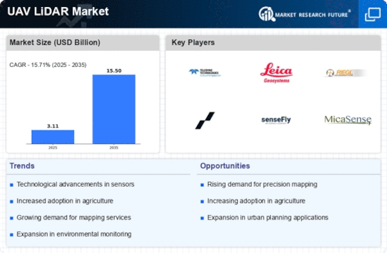
    As per MRFR analysis, the UAV LiDAR Market Size was estimated at 3.113 USD Billion in 2024. The UAV LiDAR industry is projected to grow from 3.602 USD Billion in 2025 to 15.5 USD Billion by 2035, exhibiting a compound annual growth rate (CAGR) of 15.71 during the forecast period 2025 - 2035.

    Key Market Trends & Highlights

    The UAV LiDAR market is experiencing robust growth driven by technological advancements and increasing demand across various sectors.

    • North America remains the largest market for UAV LiDAR, driven by extensive applications in surveying and mapping.
    • The Asia-Pacific region is emerging as the fastest-growing market, fueled by rapid urbanization and infrastructure development.
    • Surveying continues to dominate the market, while mapping applications are witnessing the highest growth rates due to evolving technological capabilities.
    • Key market drivers include the rising demand for precision mapping and advancements in UAV technology, which are enhancing operational efficiencies.

    Market Size & Forecast

    2024 Market Size 3.113 (USD Billion)
    2035 Market Size 15.5 (USD Billion)
    CAGR (2025 - 2035) 15.71%

    Major Players

    Teledyne Technologies (US), Leica Geosystems (CH), RIEGL Laser Measurement Systems (AT), Quantum Systems (DE), senseFly (CH), MicaSense (US), Velodyne Lidar (US), Phoenix LiDAR Systems (US), Aerial Mapping (US)

    UAV LiDAR Market Trends

    The UAV LiDAR Market is currently experiencing a transformative phase, characterized by rapid technological advancements and increasing adoption across various sectors. The integration of UAV technology with LiDAR systems has enabled more efficient data collection and analysis, which is particularly beneficial in industries such as agriculture, forestry, and urban planning. As organizations seek to enhance operational efficiency and improve decision-making processes, the demand for UAV LiDAR solutions continues to grow. Furthermore, the ability to capture high-resolution topographical data in real-time is reshaping traditional surveying methods, making them more accessible and cost-effective. In addition to technological innovations, regulatory frameworks are evolving to accommodate the expanding use of UAVs equipped with LiDAR. Governments are recognizing the potential of these systems for applications such as infrastructure monitoring and environmental assessments. This shift in policy is likely to foster a more conducive environment for market growth. Moreover, as awareness of the benefits of UAV LiDAR technology spreads, more industries are likely to explore its applications, potentially leading to a broader market landscape. Overall, the UAV LiDAR Market appears poised for continued expansion, driven by advancements in technology and supportive regulatory measures.

    Technological Advancements

    The UAV LiDAR Market is witnessing rapid technological progress, with innovations enhancing data accuracy and processing speed. These advancements are enabling more detailed and efficient mapping solutions, which are crucial for various applications.

    Regulatory Developments

    Evolving regulations are facilitating the integration of UAV LiDAR systems into mainstream operations. Governments are increasingly recognizing the utility of these technologies for monitoring and assessment purposes, which may lead to broader acceptance.

    Sector Diversification

    The market is expanding into diverse sectors beyond traditional applications. Industries such as construction, mining, and environmental management are increasingly adopting UAV LiDAR solutions, indicating a trend towards wider utilization.

    The integration of UAV LiDAR technology into various sectors is poised to enhance data collection efficiency and accuracy, thereby transforming traditional surveying and mapping methodologies.

    U.S. Geological Survey (USGS)

    UAV LiDAR Market Drivers

    Advancements in UAV Technology

    The UAV LiDAR Market is significantly influenced by advancements in UAV technology, which enhance the capabilities and applications of LiDAR systems. Innovations such as improved battery life, increased payload capacity, and enhanced flight stability allow UAVs to operate more effectively in diverse environments. These technological improvements enable longer flight times and the ability to cover larger areas, making UAV LiDAR solutions more attractive to industries such as construction and environmental monitoring. Furthermore, the integration of artificial intelligence and machine learning algorithms into UAV systems is expected to streamline data processing and analysis, thereby increasing the efficiency of LiDAR data utilization. As these advancements continue to evolve, they are likely to expand the market's reach, attracting new users and applications that require high-quality geospatial data.

    Regulatory Support for UAV Operations

    The UAV LiDAR Market benefits from regulatory support that facilitates the integration of UAV technology into various sectors. Governments are increasingly recognizing the potential of UAVs for applications such as infrastructure inspection, land surveying, and disaster management. As regulations evolve to accommodate the safe operation of UAVs, more businesses are likely to adopt UAV LiDAR systems to enhance their operational capabilities. This regulatory environment not only promotes innovation but also encourages investment in UAV technology, as companies seek to comply with safety and operational standards. The establishment of clear guidelines and frameworks for UAV operations is expected to drive market growth, as stakeholders gain confidence in the reliability and safety of UAV LiDAR applications.

    Growing Environmental Monitoring Needs

    The UAV LiDAR Market is witnessing a surge in demand driven by the growing need for environmental monitoring and management. As concerns regarding climate change and natural resource depletion intensify, organizations are increasingly utilizing UAV LiDAR technology to conduct detailed assessments of ecosystems, forests, and water bodies. This technology allows for the collection of critical data on vegetation structure, biomass estimation, and habitat mapping, which are essential for effective environmental conservation efforts. The market is expected to expand as regulatory bodies and environmental agencies adopt UAV LiDAR solutions to enhance their monitoring capabilities. Additionally, the ability to conduct non-invasive surveys with minimal ecological impact positions UAV LiDAR as a preferred choice for environmental studies, further solidifying its role in sustainable development initiatives.

    Increased Demand for Precision Mapping

    The UAV LiDAR Market experiences heightened demand for precision mapping solutions across various sectors, including agriculture, forestry, and urban planning. As industries increasingly rely on accurate geospatial data, UAV LiDAR technology provides high-resolution topographic information that enhances decision-making processes. The market is projected to grow significantly, with estimates suggesting a compound annual growth rate of over 20% in the coming years. This growth is driven by the need for detailed terrain analysis and the ability to capture complex landscapes efficiently. Consequently, organizations are investing in UAV LiDAR systems to improve operational efficiency and reduce costs associated with traditional surveying methods. The integration of UAV LiDAR technology into existing workflows is likely to further propel the market, as stakeholders recognize the value of precise data in optimizing resource management.

    Rising Adoption in Infrastructure Development

    The UAV LiDAR Market is experiencing a notable increase in adoption within the infrastructure development sector. As urbanization accelerates, the demand for efficient and accurate surveying methods becomes paramount. UAV LiDAR technology offers a rapid and cost-effective solution for capturing detailed topographic data, which is essential for planning and executing infrastructure projects. The ability to generate high-resolution 3D models facilitates better project visualization and risk assessment, thereby improving overall project outcomes. Market analysts project that the infrastructure sector will continue to be a key driver of UAV LiDAR adoption, particularly in road construction, bridge inspection, and utility management. This trend indicates a robust future for UAV LiDAR technology as it becomes integral to modern infrastructure development practices.

    Market Segment Insights

    By Application: Surveying (Largest) vs. Mapping (Fastest-Growing)

    The UAV LiDAR market exhibits a diverse distribution of applications, with surveying leading the charge as the largest segment. This dominance is driven by the increasing reliance on UAV technology in various surveying tasks, particularly for topographic surveys and urban planning. Following closely is the mapping segment, which has gained traction due to its capabilities in producing precise geospatial data for a variety of applications, from environmental monitoring to infrastructure development. The growth trends within the UAV LiDAR application segment indicate robust expansion, particularly in sectors such as agriculture and infrastructure. The agricultural segment leverages UAV LiDAR for enhanced crop mapping and resource management, while infrastructure projects utilize it for precise planning and maintenance. The demand for real-time, accurate data has led to an uptick in adoption rates, propelling the mapping segment as the fastest-growing area in this market.

    Surveying (Dominant) vs. Mapping (Emerging)

    The surveying segment of the UAV LiDAR market is characterized by its extensive use in obtaining high-resolution topographical data for land assessment and urban development. This segment is the dominant force, offering comprehensive solutions for land surveyors and planners, thanks to its ability to combine aerial perspectives with precise measurements. In contrast, the mapping segment, while emerging, is rapidly gaining market share due to increasing demand for detailed geospatial analysis. This segment highlights the importance of UAV LiDAR in various industries, including environmental management and disaster response, as it provides critical data for decision-making and resource allocation.

    By Platform Type: Fixed-Wing UAV (Largest) vs. Rotary-Wing UAV (Fastest-Growing)

    In the UAV LiDAR market, Fixed-Wing UAVs hold the largest share due to their ability to cover large areas efficiently and their extended flight endurance. They are widely adopted for applications that require extensive data collection over expansive terrains, making them a preferred choice among surveyors and environmentalists. Conversely, Rotary-Wing UAVs, though smaller in market share, are rapidly gaining traction. Their flexibility and ability to hover allow detailed inspections and surveys in more complex environments, making them increasingly popular in urban applications. The growth of the Rotary-Wing UAV segment is being driven by advancements in drone technology and LiDAR integration, making them more accessible and easier to operate. Additionally, the demand for high-resolution mapping and surveying in industries such as construction, agriculture, and forestry is fueling their adoption. As urban areas expand, the need for versatile and nimble UAVs to navigate tight spaces and dynamic environments places Rotary-Wing UAVs at the forefront of market growth trends, indicating a bright future for this segment.

    Fixed-Wing UAV (Dominant) vs. Rotary-Wing UAV (Emerging)

    Fixed-Wing UAVs are characterized by their aerodynamic design, allowing for long-distance, high-altitude flights that are essential for comprehensive mapping and survey tasks. Their dominant position in the UAV LiDAR market is attributed to their capability of covering large geographic areas in a single flight while maintaining stable data collection. In contrast, Rotary-Wing UAVs, with their ability to perform vertical takeoffs and landings, are emerging as essential tools for projects requiring precision and agility. Their niche applicability in urban environments and smaller plots makes them an attractive option for industries aiming for high detail and flexibility in data gathering. As the technology advances, both platforms are expected to complement each other, catering to various sector needs.

    By End Use: Government (Largest) vs. Commercial (Fastest-Growing)

    The UAV LiDAR market is witnessing a significant distribution of market share across various end-user segments. The government sector holds the largest share, primarily due to its extensive utilization of UAV LiDAR for infrastructure development, environmental monitoring, and emergency response planning. In contrast, the commercial segment is rapidly expanding, driven by industries such as construction, agriculture, and mining, which are increasingly adopting UAV LiDAR technology to enhance operational efficiency and decision-making processes. Growth trends in the UAV LiDAR market are heavily influenced by the increasing integration of advanced technology, such as AI and machine learning, within UAV systems. The demand for high-precision mapping and surveying solutions is propelling commercial applications, while government investments in smart city initiatives and disaster management continue to bolster the government's share. These sectors are poised for substantial growth as UAV LiDAR technology becomes more accessible and affordable for a wider range of applications.

    Government (Dominant) vs. Commercial (Emerging)

    The government segment in the UAV LiDAR market is characterized by a strong emphasis on infrastructure planning, environmental assessment, and public safety. Government agencies utilize UAV LiDAR for creating highly accurate maps and models, which are crucial for urban planning and disaster management. Their established budgets and sustained funding for these technologies position them as a dominant player in the market. In contrast, the commercial segment is emerging rapidly, fueled by diverse industries recognizing the efficiency gains offered by UAV LiDAR. This segment includes construction, agriculture, and transportation companies that leverage UAV LiDAR for topographical surveys and asset inspections. The commercial market's adaptability and innovation focus are essential for its rapid growth, allowing stakeholders to optimize operations and reduce operational costs.

    By Technology: Airborne LiDAR (Largest) vs. Terrestrial LiDAR (Fastest-Growing)

    In the UAV LiDAR market, Airborne LiDAR holds a significant portion of the market share, largely due to its extensive applications across various industries such as agriculture, forestry, and urban planning. This segment's ability to cover large areas quickly and efficiently makes it the preferred choice among professionals requiring high-resolution mapping. On the other hand, Terrestrial LiDAR, while possessing a smaller market share, is gaining traction thanks to its precision and effectiveness in detailed surveys and construction projects, catering to industries that require meticulous data collection.

    Technology: Airborne LiDAR (Dominant) vs. Terrestrial LiDAR (Emerging)

    Airborne LiDAR has established itself as the dominant technology within the UAV LiDAR market due to its capability to conduct vast area surveys with remarkable efficiency and high accuracy. This remote sensing method utilizes drones equipped with laser scanning technology to capture detailed topographic data, which is invaluable for project planning and environmental monitoring. Conversely, Terrestrial LiDAR is an emerging technology that is rapidly gaining popularity, especially in urban environments where detailed and localized data is crucial. It is favored for applications in civil engineering and construction, where precision and high detail are paramount, leading to increased adoption and innovation within this segment.

    Get more detailed insights about UAV LiDAR Market

    Regional Insights

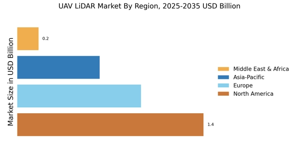
    The  UAV LiDAR Market was poised for significant growth across various regions, with North America showcasing a majority holding, being valued at 1.3 USD Billion in 2023 and expected to reach 4.8 USD Billion by 2032. This dominance was attributed to advanced technological adoption and strong investments in UAV applications.

    Europe followed closely with a valuation of 0.85 USD Billion in 2023, projected to expand to 3.2 USD Billion, highlighting its increasing reliance on UAV LiDAR systems for surveying and mapping activities. The APAC region, valued at 0.54 USD Billion in 2023 and anticipated to grow to 2.0 USD Billion, indicated rising demand driven by infrastructure projects and smart city initiatives.

    South America was relatively smaller but demonstrates growth potential with a valuation of 0.2 USD Billion in 2023, rising to 0.75 USD Billion, primarily focusing on urban development. Lastly, the MEA region began at 0.1 USD Billion in 2023 and is set to reach 0.25 USD Billion, reflecting the growing interest in UAV technologies for environmental monitoring and resource management.

    Overall, the Regional segmentation of the  UAV LiDAR Market showcased diverse opportunities and varying levels of market maturity, influenced by regional application needs and technological advancements.

     UAV LiDAR Market Regional

    Source Primary Research, Secondary Research, Market Research Future Database and Analyst Review


    Key Players and Competitive Insights

    The  UAV LiDAR Market has witnessed significant growth due to the increasing adoption of drone technology across various industries such as agriculture, construction, forestry, and environmental monitoring. As the market expands, competition intensifies among key players, each striving to enhance their product offerings and service capabilities to gain a competitive edge.

    The integration of advanced technologies and innovations, such as real-time data processing and improved sensor accuracy, has become paramount for companies looking to capitalize on the growing demand for UAV LiDAR solutions.

    Strategic partnerships, mergers, and acquisitions are common strategies employed by companies to strengthen their market presence and fortify their research and development efforts. The market is characterized by a mixture of established players and emerging startups, which adds to the dynamic nature of the competitive landscape.

    Delair has emerged as a strong contender in the  UAV LiDAR Market, showcasing its commitment to technological advancements and customer satisfaction. The company has developed a comprehensive portfolio of UAV solutions designed to cater to various sectors, enabling efficient data collection and analysis.

    Delair's systems are known for their robustness and reliability, offering high-resolution LiDAR data that is crucial for applications such as topographic mapping and vegetation analysis. The company's focus on providing end-to-end services, from data acquisition to processing and analysis, positions it well in a market that increasingly values integrated solutions.

    Additionally, Delair's strategic collaborations and partnerships with industry stakeholders enhance its capabilities, enabling access to diverse markets and customer bases, ultimately strengthening its competitive standing in the UAV LiDAR arena.

    OptiMason, on the other hand, has carved out a niche for itself within the  UAV LiDAR Market through its innovative approach and focus on quality. The company emphasizes the importance of precision and efficiency in its UAV LiDAR solutions, catering specifically to the needs of its clients.

    OptiMason is particularly recognized for its advanced data processing capabilities, which enhance the usability and accuracy of LiDAR data. The company's commitment to continuous research and development allows it to stay ahead of technological trends, integrating new advancements into its product offerings.

    Furthermore, OptiMason's strong customer support and service infrastructure contribute to its reputation as a reliable player in the market. By maintaining a strong emphasis on customer feedback and adaptability, OptiMason effectively positions itself as a forward-thinking leader in the rapidly evolving UAV LiDAR landscape.

    Key Companies in the UAV LiDAR Market market include

    Industry Developments

    • Q2 2024: Velodyne Lidar and Emesent Announce Partnership to Advance Autonomous UAV Mapping Velodyne Lidar announced a strategic partnership with Emesent to integrate Velodyne’s LiDAR sensors into Emesent’s autonomous drone systems, aiming to enhance high-precision mapping and surveying capabilities for industrial and mining applications.
    • Q2 2024: YellowScan Launches New Surveyor Ultra UAV LiDAR System YellowScan introduced the Surveyor Ultra, a new lightweight UAV LiDAR system designed for high-density point cloud generation, targeting applications in forestry, civil engineering, and environmental monitoring.
    • Q3 2024: DJI Unveils Zenmuse L2 LiDAR Payload for Enterprise Drones DJI launched the Zenmuse L2, a next-generation LiDAR payload for its Matrice drone series, offering improved range, accuracy, and real-time 3D data processing for surveying and infrastructure inspection.
    • Q3 2024: Teledyne FLIR Acquires UAV LiDAR Specialist GeoSLAM Teledyne FLIR completed the acquisition of GeoSLAM, a UK-based company specializing in UAV-mounted LiDAR mapping solutions, to expand its portfolio in geospatial and autonomous navigation technologies.
    • Q4 2024: RIEGL Opens New North American Headquarters to Support UAV LiDAR Growth RIEGL inaugurated a new North American headquarters in Orlando, Florida, to expand its manufacturing and support capabilities for UAV LiDAR systems, reflecting increased demand in the region.
    • Q4 2024: Microdrones Secures Major Contract with European Rail Operator for UAV LiDAR Mapping Microdrones announced a multi-year contract to provide UAV LiDAR mapping services for a leading European rail operator, supporting infrastructure monitoring and digital twin initiatives.
    • Q1 2025: Quanergy Systems Raises $40 Million to Accelerate UAV LiDAR Development Quanergy Systems closed a $40 million funding round to advance the development of lightweight, high-resolution LiDAR sensors for UAV applications in surveying and smart city projects.
    • Q1 2025: Hexagon AB Appoints New CEO to Drive UAV LiDAR Expansion Hexagon AB announced the appointment of a new CEO, emphasizing a strategic focus on expanding its UAV LiDAR business through innovation and global partnerships.
    • Q2 2025: Phoenix LiDAR Systems Launches Next-Gen MiniRanger UAV LiDAR Platform Phoenix LiDAR Systems released the MiniRanger, a compact UAV LiDAR platform designed for rapid deployment in urban mapping, disaster response, and environmental monitoring.
    • Q2 2025: Trimble Partners with Delair to Integrate UAV LiDAR into Construction Workflows Trimble announced a partnership with Delair to integrate UAV LiDAR data into Trimble’s construction management software, streamlining site surveys and progress monitoring.
    • Q3 2025: LeddarTech Receives Regulatory Approval for UAV LiDAR Sensor in Europe LeddarTech obtained CE certification for its new UAV LiDAR sensor, enabling commercial deployment across European Union member states for infrastructure and environmental applications.
    • Q3 2025: GreenValley International Opens R&D Center Focused on UAV LiDAR in Silicon Valley GreenValley International opened a new research and development center in Silicon Valley dedicated to advancing UAV LiDAR hardware and software for forestry, mining, and urban planning.


    Future Outlook

    UAV LiDAR Market Future Outlook

    The UAV LiDAR Market is projected to grow at a 15.71% CAGR from 2024 to 2035, driven by advancements in technology, increased demand for aerial data, and expanding applications across industries.

    New opportunities lie in:

    • Development of specialized UAV LiDAR systems for precision agriculture.
    • Integration of AI analytics for enhanced data interpretation.
    • Expansion into emerging markets with tailored UAV solutions.

    By 2035, the UAV LiDAR Market is expected to be robust, reflecting substantial growth and innovation.

    Market Segmentation

    UAV LiDAR Market End Use Outlook

    • Government
    • Commercial
    • Defense
    • Research

    UAV LiDAR Market Technology Outlook

    • Airborne LiDAR
    • Terrestrial LiDAR

    UAV LiDAR Market Application Outlook

    • Surveying
    • Mapping
    • Agriculture
    • Forestry
    • Infrastructure

    UAV LiDAR Market Platform Type Outlook

    • Fixed-Wing UAV
    • Rotary-Wing UAV
    • Hybrid UAV

    Report Scope

    MARKET SIZE 20243.113(USD Billion)
    MARKET SIZE 20253.602(USD Billion)
    MARKET SIZE 203515.5(USD Billion)
    COMPOUND ANNUAL GROWTH RATE (CAGR)15.71% (2024 - 2035)
    REPORT COVERAGERevenue Forecast, Competitive Landscape, Growth Factors, and Trends
    BASE YEAR2024
    Market Forecast Period2025 - 2035
    Historical Data2019 - 2024
    Market Forecast UnitsUSD Billion
    Key Companies ProfiledMarket analysis in progress
    Segments CoveredMarket segmentation analysis in progress
    Key Market OpportunitiesIntegration of artificial intelligence enhances data processing capabilities in the UAV LiDAR Market.
    Key Market DynamicsTechnological advancements in UAV LiDAR systems drive competitive dynamics and enhance data acquisition capabilities across various industries.
    Countries CoveredNorth America, Europe, APAC, South America, MEA

    Market Highlights

    Author
    Sejal Akre
    Senior Research Analyst

    She has over 5 years of rich experience, in market research and consulting providing valuable market insights to client. Hands on expertise in management consulting, and extensive knowledge in domain including ICT, Automotive & Transportation and Aerospace & Defense. She is skilled in Go-to market strategy, industry analysis, market sizing, in depth company profiling, competitive intelligence & benchmarking and value chain amongst others.

    Leave a Comment

    FAQs

    What is the projected market size of the UAV LiDAR Market by 2032?

    The UAV LiDAR Market is expected to reach a value of 10.0 USD Billion by 2032.

    What is the expected CAGR for the UAV LiDAR Market from 2024 to 2032?

    The UAV LiDAR Market is projected to grow at a CAGR of 15.71% from 2024 to 2032.

    Which region is expected to hold the largest market share in the UAV LiDAR Market by 2032?

    North America is anticipated to dominate the UAV LiDAR Market with a projected value of 4.8 USD Billion by 2032.

    How will the market size for the Surveying application in UAV LiDAR change by 2032?

    The Surveying application segment is forecasted to grow to 3.0 USD Billion by 2032.

    What is the projected market size for the Mapping application in the UAV LiDAR Market by 2032?

    The Mapping application segment is expected to reach a market size of 2.3 USD Billion by 2032.

    Which companies are considered major players in the UAV LiDAR Market?

    Key players include Delair, Velodyne Lidar, Hexagon AB, senseFly, and Trimble Inc., among others.

    What market value is expected for the Agriculture application in UAV LiDAR by 2032?

    The Agriculture application segment is projected to reach a market value of 1.8 USD Billion by 2032.

    How has the Infrastructure application segment's market value changed from 2023 to 2032?

    The Infrastructure segment is expected to grow from 0.39 USD Billion in 2023 to 1.4 USD Billion by 2032.

    What is the anticipated market size for the APAC region in the Global UAV LiDAR Market by 2032?

    The APAC region is expected to grow to a market size of 2.0 USD Billion by 2032.

    What will be the total market value of the Global UAV LiDAR Market in North America by 2032?

    The total market value of the Global UAV LiDAR Market in North America is expected to be 4.8 USD Billion by 2032.

    Download Free Sample

    Kindly complete the form below to receive a free sample of this Report

    Case Study
    Chemicals and Materials

    Compare Licence

    ×
    Features License Type
    Single User Multiuser License Enterprise User
    Price $4,950 $5,950 $7,250
    Maximum User Access Limit 1 User Upto 10 Users Unrestricted Access Throughout the Organization
    Free Customization
    Direct Access to Analyst
    Deliverable Format
    Platform Access
    Discount on Next Purchase 10% 15% 15%
    Printable Versions