Growing Demand for Precision Mapping
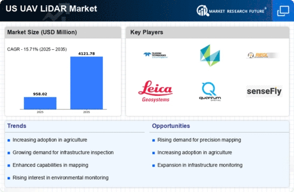
The increasing need for precision mapping in various sectors is driving the uav lidar market. Industries such as construction, forestry, and urban planning are increasingly relying on accurate topographical data to enhance project efficiency. The uav lidar market is projected to reach approximately $1.2 billion by 2026, reflecting a compound annual growth rate (CAGR) of around 15% from 2021. This growth is attributed to the technology's ability to capture high-resolution data quickly and cost-effectively, which is essential for informed decision-making in land management and infrastructure development. As organizations seek to optimize their operations, the demand for UAVs equipped with lidar systems is expected to rise, further propelling the uav lidar market forward.
Enhanced Data Collection Capabilities
The uav lidar market is experiencing a surge in demand due to enhanced data collection capabilities offered by UAVs. These systems can capture vast amounts of data in a fraction of the time compared to traditional methods. For instance, UAVs can cover large areas, collecting data at a rate of up to 1000 points per second, which is crucial for applications such as environmental monitoring and disaster management. The ability to gather detailed 3D models and high-resolution imagery allows for better analysis and planning. As industries recognize the value of real-time data, the uav lidar market is likely to expand, with projections indicating a market value of $1.5 billion by 2027.
Integration with Advanced Technologies
The integration of UAV lidar systems with advanced technologies such as artificial intelligence (AI) and machine learning is a key driver for the uav lidar market. This synergy enhances data processing capabilities, enabling more accurate analysis and interpretation of lidar data. For example, AI algorithms can identify patterns and anomalies in the data, which is particularly beneficial in sectors like mining and environmental assessment. The uav lidar market is expected to benefit from this trend, as organizations increasingly adopt these technologies to improve operational efficiency. Analysts predict that the market could grow by 20% annually as more companies leverage these integrated solutions.
Increased Focus on Environmental Monitoring
The growing emphasis on environmental monitoring and conservation efforts is significantly impacting the uav lidar market. As climate change and environmental degradation become pressing concerns, organizations are turning to UAV lidar technology for effective monitoring of natural resources and habitats. The ability to collect detailed data on vegetation, topography, and land use is invaluable for environmental assessments and conservation planning. The uav lidar market is projected to grow as more agencies and organizations invest in these technologies to support sustainability initiatives. This trend suggests a promising outlook for the uav lidar market as it aligns with broader environmental goals.
Rising Investment in Infrastructure Development
The uav lidar market is being positively influenced by rising investments in infrastructure development across the United States. Government initiatives aimed at improving transportation networks, utilities, and urban infrastructure are creating a demand for precise surveying and mapping solutions. The ability of UAV lidar systems to provide accurate and timely data is essential for planning and executing large-scale projects. With federal and state funding for infrastructure projects expected to exceed $1 trillion over the next decade, the uav lidar market is likely to see substantial growth. This trend indicates a robust future for UAV lidar applications in infrastructure planning and management.


