• Cat-intel
  • MedIntelliX
  • Resources
  • About Us
  • Request Free Sample ×

    Kindly complete the form below to receive a free sample of this Report

    Leading companies partner with us for data-driven Insights

    clients tt-cursor
    Hero Background

    Airborne LiDAR Market

    ID: MRFR/A&D/4558-HCR
    200 Pages
    Sejal Akre
    October 2025

    Airborne LiDAR Market Research Report By Application (Mapping, Forest Management, Archaeology, Urban Planning, Coastal Studies), By Technology (Laser Scanning, Photographic LiDAR, Bathymetric LiDAR, Multispectral LiDAR), By End-use (Government Agencies, Construction Development, Environmental Monitoring, Transportation), By Platform (Fixed-Wing Aircraft, Helicopters, Drones, Satellite), and By Regional (North America, Europe, South America, Asia Pacific, Middle East and Africa)-Forecast to 2035

    Share:
    Download PDF ×

    We do not share your information with anyone. However, we may send you emails based on your report interest from time to time. You may contact us at any time to opt-out.

    Airborne LiDAR Market Infographic
    Purchase Options

    Airborne LiDAR Market Summary

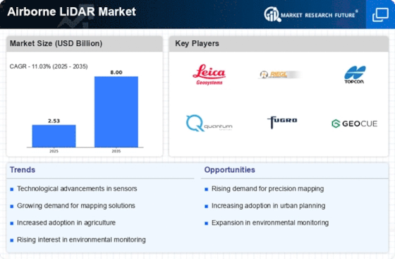
    As per MRFR analysis, the Airborne LiDAR Market Size was estimated at 2.53 USD Billion in 2024. The Airborne LiDAR industry is projected to grow from 2.809 USD Billion in 2025 to 7.998 USD Billion by 2035, exhibiting a compound annual growth rate (CAGR) of 11.03 during the forecast period 2025 - 2035.

    Key Market Trends & Highlights

    The Airborne LiDAR Market is poised for substantial growth driven by technological advancements and increasing applications across various sectors.

    • Technological advancements in LiDAR systems are enhancing data accuracy and processing speed, thereby expanding their utility.
    • North America remains the largest market for Airborne LiDAR, while the Asia-Pacific region is emerging as the fastest-growing market.
    • The mapping segment continues to dominate the market, whereas the coastal studies segment is witnessing rapid growth due to rising environmental concerns.
    • Increasing demand for high-resolution mapping and government investments in infrastructure development are key drivers propelling market expansion.

    Market Size & Forecast

    2024 Market Size 2.53 (USD Billion)
    2035 Market Size 7.998 (USD Billion)
    CAGR (2025 - 2035) 11.03%

    Major Players

    Leica Geosystems (CH), Riegl Laser Measurement Systems (AT), Topcon Positioning Systems (US), Quantum Spatial (US), Fugro (NL), GeoCue Group (US), Merrick & Company (US), Teledyne Optech (CA)

    Airborne LiDAR Market Trends

    The Airborne LiDAR Market is currently experiencing a notable transformation, driven by advancements in technology and increasing demand across various sectors. The integration of high-resolution imaging and real-time data processing capabilities is enhancing the accuracy and efficiency of mapping and surveying applications. This evolution is particularly evident in industries such as forestry, agriculture, and urban planning, where precise topographical data is essential for decision-making. Furthermore, the growing emphasis on environmental monitoring and disaster management is propelling the adoption of airborne LiDAR systems, as they provide critical insights into terrain changes and vegetation health. In addition to technological advancements, the Airborne LiDAR Market is witnessing a shift towards more sustainable practices. Companies are increasingly focusing on eco-friendly solutions, which may include the use of drones and other unmanned aerial vehicles for data collection. This trend not only reduces the carbon footprint associated with traditional surveying methods but also enhances operational efficiency. As the market continues to evolve, it appears poised for further growth, with innovations likely to emerge that will expand its applications and improve accessibility for various stakeholders. The future landscape of the Airborne LiDAR Market suggests a dynamic interplay between technology, sustainability, and user demand, shaping its trajectory in the coming years.

    Technological Advancements

    The Airborne LiDAR Market is witnessing rapid technological progress, particularly in sensor capabilities and data processing techniques. Enhanced sensors are providing higher resolution data, which is crucial for applications requiring detailed topographical information. Additionally, advancements in software algorithms are enabling faster data analysis, thereby improving the overall efficiency of LiDAR systems.

    Sustainability Initiatives

    There is a growing trend towards sustainability within the Airborne LiDAR Market, as companies seek to minimize their environmental impact. The adoption of drones and other unmanned aerial systems for data collection is becoming more prevalent, as these methods are often more eco-friendly compared to traditional surveying techniques. This shift not only supports environmental goals but also enhances operational efficiency.

    Diverse Applications

    The range of applications for airborne LiDAR technology is expanding, with sectors such as agriculture, forestry, and urban planning increasingly utilizing this technology. The ability to gather precise data for various purposes, including land management and infrastructure development, indicates a broadening scope for the Airborne LiDAR Market, suggesting potential growth opportunities.

    The increasing demand for precise topographical data and enhanced mapping capabilities is driving advancements in Airborne LiDAR technology, which is poised to transform various sectors including forestry, agriculture, and urban planning.

    U.S. Geological Survey (USGS)

    Airborne LiDAR Market Drivers

    Advancements in LiDAR Technology

    Advancements in LiDAR technology are propelling the growth of the Airborne LiDAR Market. Innovations such as improved sensor capabilities, enhanced data processing algorithms, and integration with other technologies like artificial intelligence are making LiDAR systems more efficient and accessible. These advancements not only increase the accuracy and speed of data collection but also reduce operational costs, making LiDAR solutions more appealing to a broader range of industries. As a result, the market is expected to see a significant uptick in adoption rates, with projections indicating a potential market size increase of 20% by 2030. This evolution in technology is likely to redefine the applications and capabilities of airborne LiDAR.

    Rising Demand for 3D Mapping Solutions

    The rising demand for 3D mapping solutions is a key driver in the Airborne LiDAR Market. As industries such as construction, mining, and agriculture seek to leverage three-dimensional data for enhanced visualization and analysis, LiDAR technology has emerged as a preferred choice. The ability to create detailed 3D models of terrain and structures facilitates better planning and execution of projects. Market analysis suggests that the 3D mapping segment is poised for substantial growth, with an anticipated increase in market share of approximately 25% over the next few years. This trend indicates a shift towards more sophisticated data representation methods, underscoring the importance of airborne LiDAR in meeting the evolving needs of various sectors.

    Growing Adoption in Environmental Monitoring

    The Airborne LiDAR Market is witnessing a growing adoption of LiDAR technology in environmental monitoring applications. As concerns regarding climate change and natural resource management intensify, organizations are increasingly utilizing LiDAR for habitat mapping, flood modeling, and forest inventory assessments. The ability of LiDAR to provide detailed and accurate data on vegetation structure and land use is particularly valuable for environmental scientists and conservationists. Recent studies indicate that the environmental monitoring segment is expected to expand at a rate of 12% annually, reflecting the increasing reliance on advanced technologies to address environmental challenges. This trend highlights the potential of airborne LiDAR to contribute to sustainable practices and informed decision-making.

    Increasing Demand for High-Resolution Mapping

    The Airborne LiDAR Market is experiencing a surge in demand for high-resolution mapping solutions. This demand is primarily driven by the need for precise topographical data in various sectors, including urban planning, forestry, and environmental monitoring. As municipalities and organizations seek to enhance their decision-making processes, the accuracy provided by LiDAR technology becomes indispensable. Recent data indicates that the market for high-resolution mapping is projected to grow at a compound annual growth rate of approximately 15% over the next five years. This growth reflects a broader trend towards data-driven decision-making, where high-quality geospatial information is crucial for effective resource management and infrastructure development.

    Government Investments in Infrastructure Development

    Government investments in infrastructure development are significantly influencing the Airborne LiDAR Market. As nations prioritize modernization and expansion of their infrastructure, the need for accurate surveying and mapping becomes paramount. LiDAR technology offers a cost-effective solution for capturing detailed geographical data, which is essential for planning and executing large-scale projects. For instance, recent initiatives in transportation and urban development have led to increased funding for LiDAR applications, with estimates suggesting that infrastructure-related projects could account for over 30% of the market share in the coming years. This trend underscores the critical role of airborne LiDAR in facilitating efficient and sustainable infrastructure development.

    Market Segment Insights

    By Application: Mapping (Largest) vs. Coastal Studies (Fastest-Growing)

    In the Airborne LiDAR Market, the application segment is notably diverse, with Mapping leading significantly in market share. Its extensive use across various industries such as urban planning, environmental monitoring, and resource management reinforces its dominant position. Following Mapping, Forest Management and Archaeology have established themselves as vital application areas, leveraging LiDAR's precision for data collection and analysis. Coastal Studies, while smaller in share, is rapidly gaining traction among stakeholders focused on environmental conservation and coastal management.

    Mapping (Dominant) vs. Coastal Studies (Emerging)

    Mapping stands as the dominant application within the Airborne LiDAR Market, characterized by its widespread utilization for topographic surveys, infrastructure assessment, and land development projects. Its ability to provide high-resolution data quickly makes it indispensable for professionals in planning and environmental management. In contrast, Coastal Studies represents an emerging application, where its utilization is expanding due to increasing concerns regarding climate change and sea-level rise. This application focuses on monitoring coastal erosion, habitat mapping, and coastal zone management, making it pivotal for sustainable development objectives. The integration of LiDAR in these studies enhances accuracy in data collection, satisfying the growing demand for detailed, real-time geographical insights.

    By Technology: Laser Scanning (Largest) vs. Multispectral LiDAR (Fastest-Growing)

    In the Airborne LiDAR Market, Laser Scanning holds the largest market share due to its widespread application in topographic mapping, forestry, and urban planning. It is preferred for its accuracy and efficiency in capturing detailed 3D representations of the Earth’s surface. Following Laser Scanning, Photographic and Bathymetric LiDAR technologies cater to specific niches like coastal mapping and underwater terrain analysis, respectively, impacting their overall market share but still demonstrating significant relevance in targeted applications. Emerging technologies like Multispectral LiDAR are rapidly gaining traction due to their ability to capture data across various wavelengths. This capability is particularly valuable in agriculture, environmental monitoring, and forestry management. The increasing demand for high-resolution data and improved analytical capabilities is driving growth in these segments. Moreover, advancements in sensor technology and data processing techniques are fostering innovation and competitiveness in the Airborne LiDAR Market, creating opportunities for both established and new players.

    Laser Scanning: Dominant vs. Multispectral LiDAR: Emerging

    Laser Scanning technology remains the dominant force in the Airborne LiDAR Market, recognized for its precision and efficiency in 3D mapping. Its applications span several industries, facilitating not only topographic surveys but also urban planning and vegetation studies. By leveraging laser beams to capture detailed topographical details, it ensures high-resolution outputs that are crucial for effective decision-making. Conversely, Multispectral LiDAR is emerging as a game-changer, capturing data at various light wavelengths to analyze vegetation health and land use patterns. This technology is crucial for sectors like agriculture and resource management, enabling stakeholders to make informed choices based on advanced spectral analysis. As the demand for precision and multi-faceted analysis grows, Multispectral LiDAR's market position is expected to strengthen, complementing established Laser Scanning methods.

    By End-use: Government Agencies (Largest) vs. Environmental Monitoring (Fastest-Growing)

    In the Airborne LiDAR Market, the distribution of market share across various end-use segments reveals that Government Agencies hold the largest share due to substantial investments in infrastructure, mapping, and surveillance applications. This sector utilizes LiDAR technology extensively for accurate terrain mapping, disaster management, and urban planning, making it an integral player in the market's overall performance. On the other hand, the Environmental Monitoring segment is recognized as the fastest-growing area within the Airborne LiDAR Market. Factors such as increasing awareness of environmental conservation, climate change impacts, and regulatory requirements are driving demand for LiDAR in monitoring forests, wetlands, and other natural resources. This growth reflects a broader trend in prioritizing sustainability and effective resource management using advanced technology.

    Government Agencies (Dominant) vs. Environmental Monitoring (Emerging)

    The Government Agencies segment represents the dominant force in the Airborne LiDAR Market, leveraging significant budgets and resources to incorporate advanced mapping technology into public projects. Their usage spans various domains, including infrastructure development, natural disaster management, and urban planning, where accuracy and precision are paramount. In contrast, the Environmental Monitoring segment is emerging rapidly, fueled by heightened concern for environmental protection and the need for precise data collection. This demand is driven by governmental regulations and initiatives aimed at sustainability. As such, environmental agencies are increasingly adopting airborne LiDAR to gain insights into land use, habitat changes, and ecosystem health, positioning this segment as a pivotal player in future market dynamics.

    By Platform: Drones (Largest) vs. Helicopters (Fastest-Growing)

    In the Airborne LiDAR Market, the distribution of market share reveals that Drones have emerged as the largest platform, capturing a significant portion due to their versatility and cost-effectiveness. Fixed-Wing Aircraft follows as a capable option for extensive coverage, while Helicopters and Satellites hold smaller shares yet serve vital roles in specialized applications. This segmentation highlights not just the dominance of Drones, but also the relevance of each platform based on specific operational needs.

    Drones (Dominant) vs. Helicopters (Emerging)

    Drones are leading the Airborne LiDAR Market given their ability to execute complex surveys with high precision and at lower operational costs than traditional platforms. Their advanced technology enables quick data acquisition across various terrain types, enhancing their appeal in numerous industries including agriculture, forestry, and construction. On the other hand, Helicopters are regarded as an emerging platform, experiencing rapid growth due to their capability to cover intricate areas and provide access to otherwise unreachable sites. Despite being overshadowed by Drones, helicopters are becoming increasingly popular for their reliability in challenging environments, thus carving out a niche market.

    Get more detailed insights about Airborne LiDAR Market

    Regional Insights

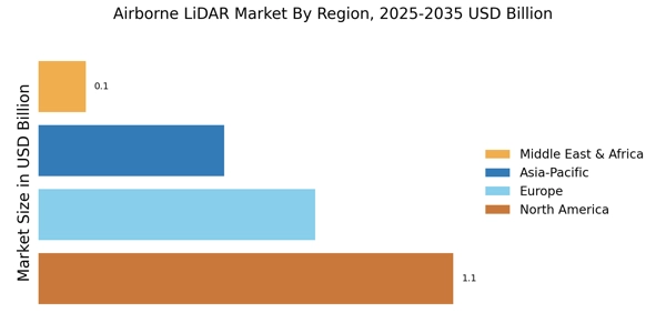
    The Regional segmentation of the Airborne LiDAR Market revealed significant insights into the market's dynamics across various geographical areas. In 2024, North America dominated the market with a valuation of 0.803 USD Billion, rising to 2.582 USD Billion by 2035, accounting for a majority holding due to advanced technological adoption and a strong focus on infrastructure development.

    Europe followed with a market valuation of 0.523 USD Billion in 2024, which is projected to reach 1.709 USD Billion in 2035, benefiting from stringent regulations and an increasing demand for accurate mapping solutions.

    The Asia Pacific region showed strong growth potential with a valuation of 0.624 USD Billion in 2024, expected to grow to 2.0 USD Billion by 2035, driven by rapid urbanization and government investments in smart city initiatives.

    South America, while smaller, is projected to rise from 0.151 USD Billion in 2024 to 0.48 USD Billion in 2035, as modern infrastructure projects gained traction. The Middle East and Africa demonstrated substantial growth potential, valued at 0.43 USD Billion in 2024 and anticipated to reach 1.229 USD Billion by 2035, driven by increased demand for precision agriculture and urban planning solutions.

    Overall, these segmented valuations highlighted the diverse growth trends and emerging opportunities within the Airborne LiDAR Market across different regions.

    Airborne LiDAR Market Regional Insights

    Source: Primary Research, Secondary Research, Market Research Future Database and Analyst Review

    Key Players and Competitive Insights

    The Airborne LiDAR Market is characterized by its rapid growth, driven by the increasing demand for high-resolution geographic data and 3D mapping capabilities across various sectors, including environmental monitoring, urban planning, and transportation.

    The competitive landscape is marked by the presence of numerous players, each vying for market share through innovations and technological advancements. Companies are actively investing in research and development to enhance their product offerings, improve accuracy, and reduce costs, thereby driving competition.

    Additionally, partnerships and collaborations are becoming more frequent as firms seek to broaden their technological capabilities and expand their geographical reach. As stakeholders examine market trends and customer preferences, they continue to strategize on delivering integrated solutions that cater to both established industries and emerging applications.

    RIEGL Laser Measurement Systems stands out in the Airborne LiDAR Market due to its commitment to innovation and quality. The company has built a solid reputation for developing advanced LiDAR technology, ensuring high precision and reliability in airborne surveying applications.

    RIEGL's strengths lie in its extensive experience in laser scanning and its ability to offer a diverse range of airborne LiDAR systems adapted to different operational requirements. Their products are known for incorporating cutting-edge technologies, such as Full Waveform Digitization, which significantly enhances data acquisition capabilities.

    This technological edge allows RIEGL to maintain a strong market presence and cater to a variety of sectors, including forestry, mining, and civil engineering, positioning them effectively against competitors.

    Hexagon AB plays a significant role in the Airborne LiDAR Market, leveraging its vast portfolio of products and services to deliver comprehensive solutions. The company offers a wide array of LiDAR systems and software that cater to various surveying and mapping needs, emphasizing the integration of sensors and software for seamless data collection and analysis.

    Hexagon's strengths include its expansive global presence and a robust supply chain that enables responsive service delivery across different regions. The company has a track record of strategic mergers and acquisitions, bolstering its capabilities and offerings in the airborne LiDAR space.

    By expanding its technological footprint and enhancing its product line, Hexagon continues to solidify its competitive edge, tapping into diverse industries and responding to the growing demands for high-quality aerial data solutions in the global market.

    Key Companies in the Airborne LiDAR Market market include

    Industry Developments

    Recent developments in the Airborne LiDAR Market reveal significant growth and technological advancements, with key players such as RIEGL Laser Measurement Systems, Hexagon AB, MAPPER, and Velodyne LiDAR leading the way.

    As of September 2023, Velodyne LiDAR expanded its collaboration with various aerospace firms to enhance its sensor technology, optimizing their applications in autonomous systems. Furthermore, in August 2023, RIEGL Laser Measurement Systems launched a new generation of airborne laser scanners, pushing the boundaries of precision and efficiency for mapping solutions.

    MAPPER has also been reporting an increase in demand for its aerial mapping services, indicating a broader market uptake, particularly in infrastructure and environmental studies. Notably, on July 2023, Teledyne Technologies announced its acquisition of a smaller LiDAR firm to broaden its portfolio and enhance service offerings in the Geospatial domain.

    The Airborne LiDAR Market has experienced substantial growth over the past few years with market valuations reflecting heightened investments and mergers indicative of an evolving landscape, emphasizing the importance of advanced mapping technologies in urban planning and natural resource management.

    Future Outlook

    Airborne LiDAR Market Future Outlook

    The Airborne LiDAR Market is projected to grow at 11.03% CAGR from 2024 to 2035, driven by advancements in technology, increasing demand for precision mapping, and environmental monitoring.

    New opportunities lie in:

    • Development of integrated LiDAR and drone solutions for enhanced data collection efficiency.
    • Expansion into emerging markets with tailored LiDAR applications for urban planning.
    • Partnerships with environmental agencies for sustainable resource management initiatives.

    By 2035, the Airborne LiDAR Market is expected to be robust, driven by innovation and diverse applications.

    Market Segmentation

    Airborne LiDAR Market End-use Outlook

    • Government Agencies
    • Construction Development
    • Environmental Monitoring
    • Transportation

    Airborne LiDAR Market Platform Outlook

    • Fixed-Wing Aircraft
    • Helicopters
    • Drones
    • Satellite

    Airborne LiDAR Market Technology Outlook

    • Laser Scanning
    • Photographic LiDAR
    • Bathymetric LiDAR
    • Multispectral LiDAR

    Airborne LiDAR Market Application Outlook

    • Mapping
    • Forest Management
    • Archaeology
    • Urban Planning
    • Coastal Studies

    Report Scope

    MARKET SIZE 20242.53(USD Billion)
    MARKET SIZE 20252.809(USD Billion)
    MARKET SIZE 20357.998(USD Billion)
    COMPOUND ANNUAL GROWTH RATE (CAGR)11.03% (2024 - 2035)
    REPORT COVERAGERevenue Forecast, Competitive Landscape, Growth Factors, and Trends
    BASE YEAR2024
    Market Forecast Period2025 - 2035
    Historical Data2019 - 2024
    Market Forecast UnitsUSD Billion
    Key Companies ProfiledMarket analysis in progress
    Segments CoveredMarket segmentation analysis in progress
    Key Market OpportunitiesIntegration of artificial intelligence enhances data processing capabilities in the Airborne LiDAR Market.
    Key Market DynamicsTechnological advancements in Airborne LiDAR enhance data accuracy, driving demand across various industries and applications.
    Countries CoveredNorth America, Europe, APAC, South America, MEA

    Market Highlights

    Author
    Sejal Akre
    Senior Research Analyst

    She has over 5 years of rich experience, in market research and consulting providing valuable market insights to client. Hands on expertise in management consulting, and extensive knowledge in domain including ICT, Automotive & Transportation and Aerospace & Defense. She is skilled in Go-to market strategy, industry analysis, market sizing, in depth company profiling, competitive intelligence & benchmarking and value chain amongst others.

    Leave a Comment

    FAQs

    What was the market size of the Airborne LiDAR Market in 2024?

    The Airborne LiDAR Market was valued at 2.53 USD Billion in 2024.

    What is the projected market size for the Airborne LiDAR Market by 2035?

    By 2035, the Airborne LiDAR Market is projected to reach a value of 8.0 USD Billion.

    What is the expected CAGR for the Airborne LiDAR Market from 2025 to 2035?

    The market is expected to grow at a CAGR of 11.03% from 2025 to 2035.

    Which region is anticipated to dominate the Airborne LiDAR Market by 2035?

    North America is anticipated to hold the largest market share, valued at 2.582 USD Billion by 2035.

    What was the market size for the Airborne LiDAR Market in Europe in 2024?

    In 2024, the market size for the Airborne LiDAR Market in Europe was valued at 0.523 USD Billion.

    Which application segment is expected to be the largest in the Airborne LiDAR Market by 2035?

    The Mapping application segment is expected to be the largest, projected at 3.2 USD Billion by 2035.

    What are the key players in the Airborne LiDAR Market?

    Major players in the market include RIEGL Laser Measurement Systems, Hexagon AB, and Velodyne LiDAR among others.

    What is the market value for the Airborne LiDAR Market in Asia Pacific by 2035?

    The market in the Asia Pacific region is expected to be valued at 2.0 USD Billion by 2035.

    How much was the Forest Management application segment valued in 2024?

    The Forest Management application segment was valued at 0.64 USD Billion in 2024.

    What are the anticipated growth drivers for the Airborne LiDAR Market?

    Key growth drivers include advancements in technology and increasing demand for accurate mapping solutions.

    Download Free Sample

    Kindly complete the form below to receive a free sample of this Report

    Case Study
    Chemicals and Materials

    Compare Licence

    ×
    Features License Type
    Single User Multiuser License Enterprise User
    Price $4,950 $5,950 $7,250
    Maximum User Access Limit 1 User Upto 10 Users Unrestricted Access Throughout the Organization
    Free Customization
    Direct Access to Analyst
    Deliverable Format
    Platform Access
    Discount on Next Purchase 10% 15% 15%
    Printable Versions