Global LiDAR in Mapping Market Overview
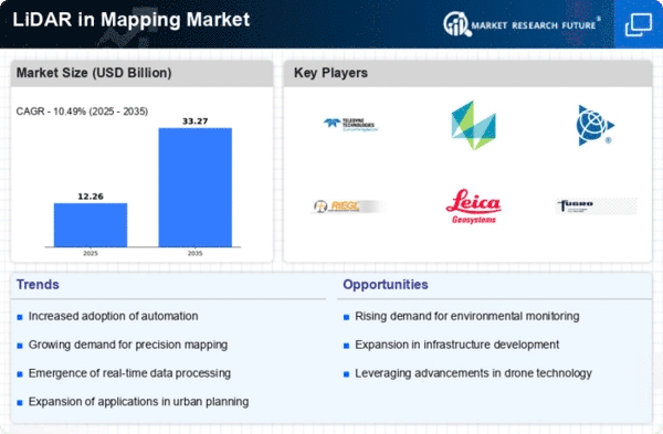
LiDAR in Mapping Market Size was estimated at 8.23 (USD Billion) in 2022.The LiDAR in Mapping Market Industry is expected to grow from 9.09(USD Billion) in 2023 to 22.3 (USD Billion) by 2032. The LiDAR in Mapping Market CAGR (growth rate) is expected to be around 10.49% during the forecast period (2024 - 2032).
Key LiDAR in Mapping Market Trends Highlighted
The LiDAR in Mapping Market is experiencing significant growth driven by advancements in technology, increasing demand for precise data, and the need for efficient mapping solutions across various sectors. The rise in applications, such as urban planning, environmental monitoring, and infrastructure development, is also fueling market expansion. Additionally, the growing adoption of autonomous vehicles and drone technology is enhancing the appeal of LiDAR systems, as they enable improved navigation and mapping accuracy. The demand for high-resolution, three-dimensional mapping has established LiDAR as an essential tool in numerous industries, effectively addressing the need for detail-oriented geospatial analysis.There are numerous opportunities to be explored in this evolving market.
The integration of LiDAR with artificial intelligence and machine learning opens doors for more automation, increasing efficiency in processing and analyzing data. Expanding applications in agriculture, forestry, and disaster management offer significant potential for adoption. Furthermore, as environmental issues gain prominence, using LiDAR for sustainable development projects can attract investments and enhance market presence. Recent trends indicate a shift toward more compact and cost-effective LiDAR solutions. Innovations in sensor technology, such as solid-state LiDAR, are promoting greater accessibility, thus expanding potential user bases.Furthermore, collaborative efforts among technology companies in developing integrated systems are increasingly common, enabling more versatile applications.
The growing emphasis on data security and privacy regulations has also influenced the evolution of the LiDAR market, prompting suppliers to adopt more robust solutions. Overall, the LiDAR in Mapping Market is on an upward trajectory, driven by technological advancements, diverse applications, and a shift toward more efficient solutions.
Source: Primary Research, Secondary Research, MRFR Database and Analyst Review
LiDAR in Mapping Market Drivers
Increasing Adoption of Advanced Mapping Technologies
The Global LiDAR in the Mapping Market Industry is experiencing a remarkable surge in demand due to the increasing adoption of advanced mapping technologies across various sectors. Industries such as construction, forestry, and environmental management are leveraging LiDAR technology for precise and accurate mapping solutions. With its ability to captivate high-resolution three-dimensional images, LiDAR provides an unparalleled advantage over traditional mapping techniques.The growing focus on improving operational efficiency, combined with a greater emphasis on data accuracy, is driving industries to invest in LiDAR systems. Furthermore, the integration of LiDAR with other technologies like GIS (Geographic Information Systems) and AI (Artificial Intelligence) enhances the analytical capabilities and operational workflows, making it an indispensable tool for decision-makers. As cities expand and infrastructure develops, the need for accurate topographical data and terrain modeling becomes crucial.
The Global LiDAR in the Mapping Market Industry finds itself at the intersection of technology and necessity, ensuring its growth trajectory as industries strive for excellence in mapping and data visualization. Additionally, the rise in government initiatives aimed at promoting smart city projects amplifies the utilization of LiDAR systems, reinforcing their significance in urban planning and development. With stakeholders recognizing the strategic advantages of adopting these technologies, the market is poised for expansion in the coming years.
Government Investments in Infrastructure Development
Government investments in infrastructure development play a significant role in enhancing the Global LiDAR in the Mapping Market Industry. As nations prioritize the modernization of public services and transportation networks, the demand for precise mapping technology becomes paramount for successful project planning and execution. LiDAR systems facilitate accurate surveying and modeling, enabling authorities to optimize resource allocation and decrease construction costs.Furthermore, the ongoing global trend of smart city initiatives encourages the integration of technology in urban planning, which directly boosts the adoption of LiDAR solutions. By leveraging LiDAR data, governments can assess geographical characteristics, environmental impacts, and spatial constraints, thereby enabling efficient and effective urban development plans.
Growing Awareness of Environmental Sustainability
The growing awareness of environmental sustainability is significantly influencing the Global LiDAR in the Mapping Market Industry. As climate change and environmental degradation gain more attention, organizations across the public and private sectors are leveraging LiDAR technology to conduct detailed assessments of environmental impact. LiDAR enables precise mapping of forests, wetlands, and other ecological systems, allowing for better management and conservation efforts.Additionally, regulators and environmental agencies are adopting these tools to monitor compliance with environmental standards, ensuring that development projects align with sustainability goals. This increasing awareness is set to foster a more significant demand for innovative LiDAR solutions that aid in environmental preservation while promoting responsible land use.
LiDAR in Mapping Market Segment Insights:
LiDAR in Mapping Market Application Insights
The LiDAR in Mapping Market has shown a robust trajectory, particularly within the Application segment, which encompasses various critical fields such as Topographic Mapping, Geographic Information Systems, Urban Planning, Forestry and Transportation. As of 2023, the market is valued at 9.09 USD Billion, reflecting its steady demand and relevance in multiple industries. Among these applications, Topographic Mapping is a dominant force, with a valuation of 3.45 USD Billion in 2023, and is anticipated to grow significantly to 8.25 USD Billion by 2032.
This prominence can be attributed to its essential role in geological surveys, landscape analysis and environmental monitoring, where precision and detail are imperative. Similarly, the Geographic Information System (GIS) market is also substantial, valued at 2.73 USD Billion in 2023 and expected to rise to 6.35 USD Billion by 2032. GIS technology is integral to spatial data analysis and is utilized across numerous sectors, including urban development, environmental management, and transportation planning, marking its critical importance in decision-making processes.
Urban Planning, another vital area, is valued at 1.64 USD Billion in 2023, expecting to reach 3.9 USD Billion by 2032. This segment is significant as it aids city planners in visualizing land usage, managing public utilities, and enhancing community development strategies. The integration of LiDAR technology facilitates more comprehensive planning models and better resource allocation. Forestry, valued at 0.95 USD Billion in 2023, with prospective growth to 2.3 USD Billion by 2032, emphasizes the importance of precision in managing forest resources, assessing timber quality, and monitoring ecosystem health. The application of LiDAR in this sector helps in conducting accurate inventory assessments and forest mapping, which are essential for sustainable practices.
Transportation, although the least valued at 0.32 USD Billion in 2023, signifies a growing area for LiDAR applications, projected to increase to 1.5 USD Billion by 2032. This market's development is driven by the need for enhanced infrastructure planning, road mapping, and safety assessments, which require advanced technology for accurate data collection. Together, these applications underscore the diverse utilizations of LiDAR in Mapping and highlight the growing integration of this technology across various sectors, driven by advances in data accuracy and processing capabilities. The trends in the LiDAR in Mapping Market data reflect an increasing demand for precise geographic information, leading to improved methodologies and operational efficiencies, which further propels the market growth.
Source: Primary Research, Secondary Research, MRFR Database and Analyst Review
LiDAR in Mapping Market Technology Insights
Key technologies within the market include Terrestrial LiDAR, Aerial LiDAR, Mobile LiDAR and Bathymetric LiDAR. Terrestrial LiDAR is crucial for land surveyors and civil engineering projects, providing precise ground data. Aerial LiDAR offers significant benefits for large-scale topographic surveys, especially in environmentally diverse and challenging terrains.Mobile LiDAR autonomous mapping techniques facilitate quicker data collection for transportation and urban planning initiatives, enhancing efficiency. Bathymetric LiDAR serves an essential role in underwater mapping and coastal management, significantly supporting marine research and infrastructure development.
The integration of these technologies underscores their importance in enhancing the accuracy and efficiency of mapping solutions, leading to the market's projected revenue growth opportunities during the forecast period up to 2032. The LiDAR in Mapping Market data reflects an exciting trend focused on enhanced precision and safety in various sectors, including agriculture, forestry, and construction, providing valuable insights into the market growth dynamics.
LiDAR in Mapping Market End Use Insights
The construction sector plays a vital role in facilitating precise topographic surveys and enabling efficient project management through accurate data. Transportation and logistics benefit significantly from LiDAR technologies, optimizing routes and enhancing safety measures. Environmental monitoring increasingly relies on LiDAR for mapping natural resources and detecting changes in land use, proving essential for conservation efforts.The mining industry utilizes LiDAR to enhance exploration techniques and improve operational efficiency.
Agriculture also presents a notable opportunity for the adoption of LiDAR technology, as it aids in crop mapping, health monitoring, and yield estimation. The various dynamics of these segments reflect the growing trend in leveraging advanced technologies to boost efficiency, minimize risks, and drive sustainability across the LiDAR in Mapping Market, underscoring an upward trajectory in overall market growth and development. Overall, the segmentation highlights the diverse applications and relevance of LiDAR, as these end uses are instrumental in shaping the future of mapping technologies across multiple sectors.
LiDAR in Mapping Market Component Insights
The Component Segment of Global LiDAR As technology advances, applications for LiDAR continue to broaden, propelling the market growth. Components such as Laser Scanners are critical as they provide accurate three-dimensional measurements essential for various mapping applications, making them a significant part of the market. GPS/GNSS Receivers enhance location precision, thereby improving the effectiveness of mapping initiatives.Software is vital for processing the collected data and transforming it into actionable insights, which contributes significantly to the market’s functionality.
Processing Units are equally important as they facilitate real-time data analysis and storage, ensuring efficient workflow in intense mapping projects. Together, these components not only cater to the demand for precision mapping but also underscore the technological trends driving the LiDAR in Mapping Market revenue. The dynamic interplay between these components highlights their importance, revealing opportunities for further innovation and development in the market landscape.
LiDAR in Mapping Market Regional Insights
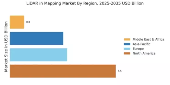
The LiDAR in Mapping Market is projected to experience substantial growth across various regions, with North America holding a majority share valued at 3.0 USD Billion in 2023 and growing to 7.1 USD Billion by 2032, indicating its significant demand driven by advanced technological integration in mapping applications. Europe follows with a valuation of 2.5 USD Billion in 2023, enhancing its position in infrastructure development and urban planning, reaching 5.8 USD Billion by 2032. The APAC region, holding 2.2 USD Billion in 2023, is gaining traction due to rapid urbanization and investments in smart city initiatives, expected to grow to 5.2 USD Billion in the coming years.
South America and MEA, while smaller in comparison, show promising growth with vales of 0.7 USD Billion and 0.69 USD Billion, respectively, in 2023, anticipated to reach 1.5 USD Billion and 1.7 USD Billion by 2032, showcasing the opportunities for LiDAR technology adoption in emerging markets. The growth trajectory, supported by trends in geospatial data collection and automation across these regions, aligns with the broader LiDAR in Mapping Market revenue expectations. Understanding this market segmentation and the varying regional dynamics is crucial for stakeholders aiming to capitalize on growth opportunities and respond to evolving industry demands.
Source: Primary Research, Secondary Research, MRFR Database and Analyst Review
LiDAR in Mapping Market Key Players and Competitive Insights:
The LiDAR in Mapping Market is witnessing significant advancements and dynamic changes driven by technological innovations, increasing demand for accurate mapping solutions, and a diverse range of applications across various sectors. As urban development, infrastructure planning, forestry management, and environmental monitoring become increasingly reliant on precise geospatial data, the competition among key players in this market intensifies. Firms are focusing on enhancing their product offerings, forming strategic partnerships, and investing in research and development initiatives to outpace competitors and capture greater market share. Companies are not only emphasizing the improvement of hardware capabilities, such as sensor accuracy and range, but are also innovating software solutions for better data processing and analytics, leading to higher effectiveness in mapping applications.
Lumentum has carved a notable position within the Global LiDAR Mapping Market by leveraging its expertise in photonics and optical technologies. The company’s strength lies in its advanced laser technology, which plays a crucial role in high-resolution mapping and distance measurement, offering superior accuracy and reliability. Lumentum's commitment to innovation is reflected in its ongoing investment in R&D to develop next-generation LiDAR solutions that cater to the evolving needs of its clientele. Moreover, Lumentum's established relationships with key stakeholders in various industries ensure a robust market presence, enhancing its adoption rates across applications such as autonomous vehicles, surveying, and geographic information systems. The company’s vast experience in manufacturing and providing optical devices further strengthens its foothold in this rapidly evolving sector.Faro Technologies is another significant contender in the Global LiDAR Mapping Market, recognized for its comprehensive suite of solutions aimed at 3D measurement, imaging, and realization.
The company’s strengths lie in its innovative LiDAR systems, which are designed to deliver high accuracy and efficiency, catering to sectors including construction, engineering, and public safety. Faro Technologies emphasizes user-friendly software that complements its hardware, enabling clients to achieve proficient data collection and analysis, which is essential for effective decision-making. As it focuses on delivering complete solutions that integrate both hardware and software, the company continuously evolves to meet changing market demands while expanding its global footprint. With a strong focus on customer satisfaction and product performance, Faro Technologies has established itself as a reliable partner in LiDAR applications across a wide range of industries.
Key Companies in the LiDAR Mapping Market Include:
- Lumentum
- Faro Technologies
- Leica Geosystems
- Velodyne Lidar
- Trimble
- YellowScan
- Riegl Laser Measurement Systems
- OmniStar
- Topcon
- SenseFly
- Merrick and Company
- Zoller + Froehlich
- Teledyne Technologies
- Quantum Spatial
- GeoSLAM
LiDAR in Mapping Market Industry Developments
Recent developments in the Global LiDAR Mapping Market have been marked by significant technological advancements and strategic partnerships among key players. Lumentum has made strides in enhancing its photonic solutions that cater to LiDAR applications, demonstrating the increasing demand for advanced sensing technologies. Velodyne Lidar recently secured a partnership with a leading automotive manufacturer to integrate its LiDAR systems into next-gen autonomous vehicles, further solidifying its position in the market. Trimble has introduced innovations aimed at improving accuracy and efficiency in surveying, while Leica Geosystems continues to expand its portfolio of geospatial solutions to cater to emerging industry needs.
On the merger and acquisition front, Teledyne Technologies has completed the acquisition of an engineering firm to enhance its capabilities in sensor technologies, while Faro Technologies is rumored to be exploring strategic acquisitions to bolster its market presence amid rising competition. Overall, companies like Riegl Laser Measurement Systems, OmniStar, Topcon, SenseFly, and Merrick & Company are continuously innovating to capture a larger market share, responding to the increasing demand for precision mapping solutions powered by LiDAR technology, thus driving substantial growth in market valuation.
LiDAR in Mapping Market Segmentation Insights
-
LiDAR in Mapping Market Application Outlook
- Topographic Mapping
- Geographic Information System
- Urban Planning
- Forestry
- Transportation
-
LiDAR in Mapping Market Technology Outlook
- Terrestrial LiDAR
- Aerial LiDAR
- Mobile LiDAR
- Bathymetric LiDAR
-
LiDAR in Mapping Market End Use Outlook
- Construction
- Transportation and Logistics
- Environmental Monitoring
- Mining and Agriculture
-
LiDAR in Mapping Market Component Outlook
- Laser Scanners
- GPS/GNSS Receivers
- Software
- Processing Units
-
LiDAR in Mapping Market Regional Outlook
- North America
- Europe
- South America
- Asia Pacific
- Middle East and Africa
Report Attribute/Metric |
Details |
Market Size 2022 |
8.23(USD Billion) |
Market Size 2023 |
9.09(USD Billion) |
Market Size 2032 |
22.3(USD Billion) |
Compound Annual Growth Rate (CAGR) |
10.49% (2024 - 2032) |
Report Coverage |
Revenue Forecast, Competitive Landscape, Growth Factors, and Trends |
Base Year |
2023 |
Market Forecast Period |
2024 - 2032 |
Historical Data |
2019 - 2023 |
Market Forecast Units |
USD Billion |
Key Companies Profiled |
Lumentum, Faro Technologies, Leica Geosystems, Velodyne Lidar, Trimble, YellowScan, Riegl Laser Measurement Systems, OmniStar, Topcon, SenseFly, Merrick and Company, Zoller + Froehlich, Teledyne Technologies, Quantum Spatial, GeoSLAM |
Segments Covered |
Application, Technology, End Use, Component, Regional |
Key Market Opportunities |
Urban planning enhancements,Infrastructure development support, Environmental monitoring demand, Autonomous vehicle integration,Agricultural precision mapping |
Key Market Dynamics |
 Increasing demand for accurate mapping, Advancements in LiDAR technology, Growing applications in various industries, Rising government investments in infrastructure, Need for environmental monitoring solutions |
Countries Covered |
North America, Europe, APAC, South America, MEA |
Frequently Asked Questions (FAQ) :
The LiDAR in Mapping Market was expected to be valued at 22.3 billion USD in 2032.
The expected CAGR for the LiDAR in Mapping Market is 10.49% from 2024 to 2032.
North America is projected to hold the largest market share, valued at 7.1 billion USD in 2032.
The market size for Topographic Mapping is expected to reach 8.25 billion USD in 2032.
Major players in the market include Lumentum, Faro Technologies, Leica Geosystems, and Velodyne Lidar.
The market size for Geographic Information Systems is expected to be 6.35 billion USD in 2032.
The APAC region is projected to grow significantly, reaching an expected market value of 5.2 billion USD in 2032.
The market size for Transportation applications is projected to increase to 1.5 billion USD in 2032.
Challenges may include high operational costs and technological complexities in implementing LiDAR systems.
The Urban Planning market is expected to grow to a size of 3.9 billion USD by 2032.