info@marketresearchfuture.com   📞  +1 (855) 661-4441(US)   📞  +44 1720 412 167(UK)
Certified Global Research Member
Isomar fd.webp Wcrc 57.webp
Key Questions Answered
  • Global Market Outlook
  • In-depth analysis of global and regional trends
  • Analyze and identify the major players in the market, their market share, key developments, etc.
  • To understand the capability of the major players based on products offered, financials, and strategies.
  • Identify disrupting products, companies, and trends.
  • To identify opportunities in the market.
  • Analyze the key challenges in the market.
  • Analyze the regional penetration of players, products, and services in the market.
  • Comparison of major players financial performance.
  • Evaluate strategies adopted by major players.
  • Recommendations
Why Choose Market Research Future?
  • Vigorous research methodologies for specific market.
  • Knowledge partners across the globe
  • Large network of partner consultants.
  • Ever-increasing/ Escalating data base with quarterly monitoring of various markets
  • Trusted by fortune 500 companies/startups/ universities/organizations
  • Large database of 5000+ markets reports.
  • Effective and prompt pre- and post-sales support.

UAV LiDAR Market Research Report By Application (Surveying, Mapping, Agriculture, Forestry, Infrastructure), By Platform Type (Fixed-Wing UAV, Rotary-Wing UAV, Hybrid UAV), By End Use (Government, Commercial, Defense, Research), By Technology (Airborne LiDAR, Terrestrial LiDAR) and By Regional (North America, Europe, South America, Asia Pacific, Middle East and Africa) - Forecast to 2032.


ID: MRFR/A&D/4795-HCR | 137 Pages | Author: Sejal Akre| January 2025

UAV LiDAR Market Overview


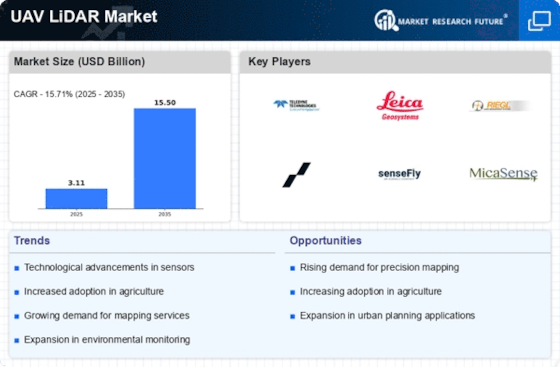
The UAV LiDAR Market Size was estimated at 2.32 (USD Billion) in 2022. The UAV LiDAR Market is expected to grow from 2.69 (USD Billion) in 2023 to 10.0 (USD Billion) by 2032. The UAV LiDAR Market CAGR (growth rate) is expected to be around 15.71% during the forecast period (2024 - 2032).


 UAV LiDAR Market


Source Primary Research, Secondary Research, MRFR Database and Analyst Review


Key UAV LiDAR Market Trends Highlighted


Due to a number of important industry factors, the  UAV LiDAR market is expanding significantly. The growing need for precise and up-to-date data in industries like forestry, urban planning, and agriculture is one of the main drivers of this growth.


UAV LiDAR technology is becoming indispensable for mapping and surveying jobs as enterprises realize the importance of accurate geographic data.


Furthermore, the effectiveness and efficiency of data collecting have been improved by developments in sensor capabilities and drone technology. UAV LiDAR solutions are being used by businesses more and more to streamline operations, cut expenses, and improve decision-making.


The UAV LiDAR market offers a plethora of chances to investigate. Faster insights from the gathered data are made possible by the new opportunities for automated data analysis presented by the combination of artificial intelligence and machine learning technology.


Additionally, as businesses look for creative answers to difficult problems, the potential uses of UAV LiDAR in environmental monitoring and catastrophe management are growing.


Collaborations between technology providers and end-users can create customized applications tailored to specific industry needs, fostering even more growth in this dynamic market. In recent times, there has been a noticeable trend toward the miniaturization of UAV systems, making them more accessible and affordable for various industries.


This trend is empowering smaller firms to utilize UAV LiDAR solutions, democratizing data access and encouraging innovation across sectors. Increased focus on sustainability and eco-friendly practices is also influencing market dynamics, with stakeholders looking for greener alternatives in data collection.


As the UAV LiDAR market continues to evolve, companies are likely to adopt more comprehensive strategies that leverage these emerging trends and address specific user requirements effectively.


UAV LiDAR Market Drivers


Increasing Demand for High-Accuracy Aerial Surveying


The  UAV LiDAR Market is experiencing significant growth due to the increasing demand for high-accuracy aerial surveying across various sectors, including construction, agriculture, forestry, and environmental monitoring.


As industries strive to enhance operational efficiency and precision, UAV LiDAR technology stands out as an essential tool for capturing detailed topographic data. With the ability to perform rapid data acquisition over vast areas, UAV LiDAR provides a cost-effective solution compared to traditional ground survey methods.


Organizations are increasingly leveraging this technology to conduct detailed mapping, assess land use, and monitor environmental changes. Furthermore, with advancements in UAV design and LiDAR sensor capabilities, the accuracy and reliability of data collected have vastly improved.


This encourages more sectors to adopt UAV LiDAR for their projects, thus propelling the market's growth. As a result, the demand for UAV LiDAR services is projected to increase, making it a key driver for the  UAV LiDAR Market in the coming years.


Technological Advancements in UAV and LiDAR Systems


Technological advancements in UAV and LiDAR systems are a significant driver for the  UAV LiDAR Market. Improved sensor technologies and drone capabilities have enabled the development of more sophisticated UAVs equipped with lightweight, high-resolution LiDAR sensors.


These innovations allow for more efficient data collection and processing, improving the applicability of UAV LiDAR in various fields. As UAV technology continues to evolve, the capabilities, such as automated flight planning and real-time data processing, enhance the attractiveness of these systems for commercial applications.


This ongoing evolution fosters interest and investment in the UAV LiDAR market, making it a vital factor for future industry growth.


Growing Adoption of UAV LiDAR in Environmental Monitoring


The growing adoption of UAV LiDAR in environmental monitoring is driving the expansion of the  UAV LiDAR Market. As concerns regarding climate change and environmental sustainability continue to rise, there is an increased focus on conserving natural resources and ecosystems.


UAV LiDAR offers an efficient means for conducting environmental assessments, tree canopy measurements, and habitat mapping. By providing high-resolution data, this technology enables researchers and policymakers to make informed decisions for conservation efforts.


The application of UAV LiDAR in monitoring changes in land use and land cover also supports effective environmental management practices, further enhancing its demand.


UAV LiDAR Market Segment Insights


UAV LiDAR Market Application Insights


The  UAV LiDAR Market gained traction across various applications, reflecting a robust valuation growth trajectory. Among diverse applications, Surveying held a majority stake, with a valuation of 0.8 USD Billion in 2023, expected to rise to 3.0 USD Billion by 2032.


Surveying not only represented a substantial share of the  UAV LiDAR Market revenue but also served crucial functions in civil engineering, construction, and urban planning, facilitating precise land assessments and property evaluations that are paramount in infrastructural development.


Mapping stood second in terms of importance, valued at 0.6 USD Billion in 2023 and anticipated to grow to 2.3 USD Billion by 2032. This application enabled the creation of detailed geographic representations that supported various sectors, such as environmental monitoring and disaster response planning, underscoring its significant role in effective decision-making.


Within this landscape, Agriculture is emerging vibrantly, with its market valuation of 0.5 USD Billion in 2023 projected to escalate to 1.8 USD Billion by 2032. This application's focus on precision farming practices allowed for enhanced crop monitoring and management, driving productivity and sustainability in agricultural operations.


Forestry also played a vital role, valued at 0.4 USD Billion in 2023 and forecasted to reach 1.5 USD Billion by 2032. Its relevance lay in forest inventory and health assessments, aiding in resource management and conservation efforts, which beame increasingly vital as environmental sustainability became a  priority.


Finally, the Infrastructure application, valued at 0.39 USD Billion in 2023 and set to grow to 1.4 USD Billion by 2032, emphasized the importance of maintenance and development of transportation and energy systems, showcasing the utility of UAV LiDAR technology in enhancing operational efficiencies.


Overall, the  UAV LiDAR Market statistics reflected a landscape where analysis and integration of UAV LiDAR across these applications not only highlighted individual segment growth but also demonstrated the compelling opportunities within diverse industrial domains driven by innovation and technological advancement.


 UAV LiDAR Market Type


Source Primary Research, Secondary Research, MRFR Database and Analyst Review


UAV LiDAR Market Platform Type Insights


The Platform Type segmentation is pivotal within this industry, encompassing Fixed-Wing UAV, Rotary-Wing UAV, and Hybrid UAV variants. Fixed-wing UAVs are noted for their extended flight time and coverage capacity, making them ideal for large-scale mapping and surveying tasks.


Conversely, Rotary-Wing UAVs are recognized for their superior maneuverability and ability to operate in confined spaces, which enhances their effectiveness in urban and specialized surveying applications.


Meanwhile, Hybrid UAVs combine features of both Fixed and Rotary-Wing types, catering to a diverse range of operational needs. The market growth is supported by increasing demand for accurate terrain mapping, infrastructure inspection, and environmental monitoring, while challenges such as regulatory hurdles and technological advancements remain.


Overall, understanding the dynamics within the Platform Type category contributes significantly to the  UAV LiDAR Market data and statistics, reflecting the industry's evolving landscape.


UAV LiDAR Market End Use Insights


The  UAV LiDAR Market is witnessing significant growth driven by its various end-use applications including Government, Commercial, Defense, and Research.


The Government segment plays a critical role, especially in mapping, surveying, and environmental monitoring, while the Commercial segment increasingly adopts UAV LiDAR for infrastructure development and agriculture management. The Defense sector relies on UAV LiDAR for reconnaissance and surveillance operations, showcasing its strategic importance.


Furthermore, the Research segment benefits from UAV LiDAR's precision in data acquisition for environmental studies and urban planning. This diverse applicability across various end uses reflects the growth potential and robustness of the  UAV LiDAR Market, with future growth ensuring an expanded footprint in each of these areas, driven by advancements in technology and increasing demand for efficient data collection methods.


Overall, the  UAV LiDAR Market segmentation portrays not only the financial statistics but also the thematic relevance of each segment, contributing to the evolving landscape of aerial data gathering methodologies.


UAV LiDAR Market Technology Insights


The market is marked by rapid evolution in its technology segment, where Airborne LiDAR has gained significant traction due to its ability to capture data over extensive areas quickly and with high precision. The increasing adoption of these systems can be attributed to rising demand in applications such as urban planning, agriculture, and environmental monitoring.


On the other hand, Terrestrial LiDAR also plays a crucial role in the market, particularly in applications requiring detailed 3D modeling for construction and infrastructure management.


The combination of both technologies enhances the overall capabilities of the UAV LiDAR Market, allowing for versatile data acquisition and analysis. As a result, this segment not only meets diverse client needs but also drives substantial advancements within the  UAV LiDAR Market.


Market trends show a push towards integrating machine learning and artificial intelligence with these technologies, further propelling innovations and creating new growth opportunities stemming from enhanced data interpretation and automation.


UAV LiDAR Market Regional Insights


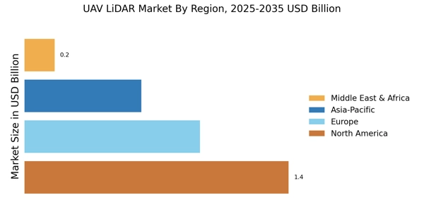
The  UAV LiDAR Market was poised for significant growth across various regions, with North America showcasing a majority holding, being valued at 1.3 USD Billion in 2023 and expected to reach 4.8 USD Billion by 2032. This dominance was attributed to advanced technological adoption and strong investments in UAV applications.


Europe followed closely with a valuation of 0.85 USD Billion in 2023, projected to expand to 3.2 USD Billion, highlighting its increasing reliance on UAV LiDAR systems for surveying and mapping activities. The APAC region, valued at 0.54 USD Billion in 2023 and anticipated to grow to 2.0 USD Billion, indicated rising demand driven by infrastructure projects and smart city initiatives.


South America was relatively smaller but demonstrates growth potential with a valuation of 0.2 USD Billion in 2023, rising to 0.75 USD Billion, primarily focusing on urban development. Lastly, the MEA region began at 0.1 USD Billion in 2023 and is set to reach 0.25 USD Billion, reflecting the growing interest in UAV technologies for environmental monitoring and resource management.


Overall, the Regional segmentation of the  UAV LiDAR Market showcased diverse opportunities and varying levels of market maturity, influenced by regional application needs and technological advancements.


 UAV LiDAR Market Regional


Source Primary Research, Secondary Research, MRFR Database and Analyst Review


UAV LiDAR Market Key Players and Competitive Insights


The  UAV LiDAR Market has witnessed significant growth due to the increasing adoption of drone technology across various industries such as agriculture, construction, forestry, and environmental monitoring. As the market expands, competition intensifies among key players, each striving to enhance their product offerings and service capabilities to gain a competitive edge.


The integration of advanced technologies and innovations, such as real-time data processing and improved sensor accuracy, has become paramount for companies looking to capitalize on the growing demand for UAV LiDAR solutions.


Strategic partnerships, mergers, and acquisitions are common strategies employed by companies to strengthen their market presence and fortify their research and development efforts. The market is characterized by a mixture of established players and emerging startups, which adds to the dynamic nature of the competitive landscape.


Delair has emerged as a strong contender in the  UAV LiDAR Market, showcasing its commitment to technological advancements and customer satisfaction. The company has developed a comprehensive portfolio of UAV solutions designed to cater to various sectors, enabling efficient data collection and analysis.


Delair's systems are known for their robustness and reliability, offering high-resolution LiDAR data that is crucial for applications such as topographic mapping and vegetation analysis. The company's focus on providing end-to-end services, from data acquisition to processing and analysis, positions it well in a market that increasingly values integrated solutions.


Additionally, Delair's strategic collaborations and partnerships with industry stakeholders enhance its capabilities, enabling access to diverse markets and customer bases, ultimately strengthening its competitive standing in the UAV LiDAR arena.


OptiMason, on the other hand, has carved out a niche for itself within the  UAV LiDAR Market through its innovative approach and focus on quality. The company emphasizes the importance of precision and efficiency in its UAV LiDAR solutions, catering specifically to the needs of its clients.


OptiMason is particularly recognized for its advanced data processing capabilities, which enhance the usability and accuracy of LiDAR data. The company's commitment to continuous research and development allows it to stay ahead of technological trends, integrating new advancements into its product offerings.


Furthermore, OptiMason's strong customer support and service infrastructure contribute to its reputation as a reliable player in the market. By maintaining a strong emphasis on customer feedback and adaptability, OptiMason effectively positions itself as a forward-thinking leader in the rapidly evolving UAV LiDAR landscape.


Key Companies in the UAV LiDAR Market Include


  • Delair

  • OptiMason

  • Velodyne Lidar

  • Hexagon AB

  • senseFly

  • Trimble Inc

  • Quantum Systems

  • Phantom AI

  • Teledyne Technologies

  • AeroPoint

  • Skyward

  • Geoslam

  • Riegl Laser Measurement Systems

  • Leica Geosystems

  • Landair Surveys


UAV LiDAR Market Developments


The  UAV LiDAR Market has witnessed significant advancements and updates recently. Companies such as Delair and senseFly are continuously innovating their technology to enhance data accuracy and processing capabilities, catering to growing demand across various sectors, including agriculture, construction, and environmental monitoring.


Emerging players like Quantum Systems and Phantom AI are also expanding their market presence by introducing cost-effective UAV LiDAR solutions that are user-friendly and efficient. On the mergers and acquisitions front, notable activities have been seen with Teledyne Technologies strengthening its portfolio through strategic acquisitions that emphasize its commitment to expanding its high-precision measurement solutions.


Companies like Velodyne Lidar and Hexagon AB are also focusing on collaborations and partnerships to enhance their operational efficiencies and broaden their market reach. The valuation of companies in this sector is on the rise, driven by robust demand and technological advancements, which, in turn, is fostering a competitive landscape, leading to innovative offerings that are set to redefine applications in surveying and mapping.


This evolving market landscape indicates a positive trajectory for the UAV LiDAR segment, underscoring its growing significance in data collection for various industries.


UAV LiDAR Market Segmentation Insights


  1. UAV LiDAR Market Application Outlook

    1. Surveying

    2. Mapping

    3. Agriculture

    4. Forestry

    5. Infrastructure


  1. UAV LiDAR Market Platform Type Outlook

    1. Fixed-Wing UAV

    2. Rotary-Wing UAV

    3. Hybrid UAV


  1. UAV LiDAR Market End Use Outlook

    1. Government

    2. Commercial

    3. Defense

    4. Research


  1. UAV LiDAR Market Technology Outlook

    1. Airborne LiDAR

    2. Terrestrial LiDAR


  1. UAV LiDAR Market Regional Outlook

    1. North America

    2. Europe

    3. South America

    4. Asia Pacific

    5. Middle East and Africa


Report Attribute/Metric Details
Market Size 2022 2.32(USD Billion)
Market Size 2023 2.69(USD Billion)
Market Size 2032 10.0(USD Billion)
Compound Annual Growth Rate (CAGR) 15.71% (2024 - 2032)
Report Coverage Revenue Forecast, Competitive Landscape, Growth Factors, and Trends
Base Year 2023
Market Forecast Period 2024 - 2032
Historical Data 2019 - 2023
Market Forecast Units USD Billion
Key Companies Profiled Delair, OptiMason, Velodyne Lidar, Hexagon AB, senseFly, Trimble Inc, Quantum Systems, Phantom AI, Teledyne Technologies, AeroPoint, Skyward, Geoslam, Riegl Laser Measurement Systems, Leica Geosystems, Landair Surveys
Segments Covered Application, Platform Type, End Use, Technology, Regional
Key Market Opportunities Increased demand for geospatial data, Growth in agricultural applications, Adoption in environmental monitoring, Expansion in infrastructure development, Advancements in drone technology
Key Market Dynamics Technological advancements, Growing demand for aerial data, Increasing applications in various industries, Cost reduction in UAV operations, Enhanced accuracy and efficiency
Countries Covered North America, Europe, APAC, South America, MEA


UAV LiDAR Market Highlights:

Frequently Asked Questions (FAQ) :

The UAV LiDAR Market is expected to reach a value of 10.0 USD Billion by 2032.

The UAV LiDAR Market is projected to grow at a CAGR of 15.71% from 2024 to 2032.

North America is anticipated to dominate the UAV LiDAR Market with a projected value of 4.8 USD Billion by 2032.

The Surveying application segment is forecasted to grow to 3.0 USD Billion by 2032.

The Mapping application segment is expected to reach a market size of 2.3 USD Billion by 2032.

Key players include Delair, Velodyne Lidar, Hexagon AB, senseFly, and Trimble Inc., among others.

The Agriculture application segment is projected to reach a market value of 1.8 USD Billion by 2032.

The Infrastructure segment is expected to grow from 0.39 USD Billion in 2023 to 1.4 USD Billion by 2032.

The APAC region is expected to grow to a market size of 2.0 USD Billion by 2032.

The total market value of the Global UAV LiDAR Market in North America is expected to be 4.8 USD Billion by 2032.

Leading companies partner with us for data-driven Insights.

client_1 client_2 client_3 client_4 client_5 client_6 client_7 client_8 client_9 client_10

Kindly complete the form below to receive a free sample of this Report

Please fill in Business Email for Quick Response

We do not share your information with anyone. However, we may send you emails based on your report interest from time to time. You may contact us at any time to opt-out.

Purchase Option
Single User $ 4,950
Multiuser License $ 5,950
Enterprise User $ 7,250
Compare Licenses
Tailored for You
  • Dedicated Research on any specifics segment or region.
  • Focused Research on specific players in the market.
  • Custom Report based only on your requirements.
  • Flexibility to add or subtract any chapter in the study.
  • Historic data from 2014 and forecasts outlook till 2040.
  • Flexibility of providing data/insights in formats (PDF, PPT, Excel).
  • Provide cross segmentation in applicable scenario/markets.