• Cat-intel
  • MedIntelliX
  • Resources
  • About Us
  • Request Free Sample ×

    Kindly complete the form below to receive a free sample of this Report

    Leading companies partner with us for data-driven Insights

    clients tt-cursor

    Remote Sensing Software Market

    ID: MRFR/ICT/29341-HCR
    128 Pages
    Ankit Gupta
    September 2025

    Remote Sensing Software Market Research Report By Application (Land Cover Mapping, Precision Agriculture, Forestry Management, Disaster Management, Water Resource Management), By Deployment Type (Cloud-Based, On-Premises), By Data Source (Satellite Imagery, Aerial Imagery, Drones, Radar, LiDAR), By End-User Industry (Agriculture, Mining, Oil and Gas, Transportation, Construction) and By Regional (North America, Europe, South America, Asia Pacific, Middle East and Africa) - Forecast to 2034

    Share:
    Download PDF ×

    We do not share your information with anyone. However, we may send you emails based on your report interest from time to time. You may contact us at any time to opt-out.

    Remote Sensing Software Market Research Report - Forecast Till 2034 Infographic
    Purchase Options
    $ 4,950.0
    $ 5,950.0
    $ 7,250.0
    Table of Contents

    Remote Sensing Software Market Summary

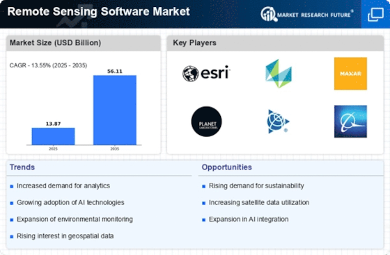
    The Global Remote Sensing Software Market is projected to grow from 13.9 USD Billion in 2024 to 56.1 USD Billion by 2035.

    Key Market Trends & Highlights

    Remote Sensing Software Key Trends and Highlights

    • The market is expected to experience a compound annual growth rate (CAGR) of 13.54% from 2025 to 2035.
    • By 2035, the market valuation is anticipated to reach 56.1 USD Billion, indicating robust growth potential.
    • In 2024, the market is valued at 13.9 USD Billion, reflecting a strong foundation for future expansion.
    • Growing adoption of remote sensing technology due to increasing demand for environmental monitoring is a major market driver.

    Market Size & Forecast

    2024 Market Size 13.9 (USD Billion)
    2035 Market Size 56.1 (USD Billion)
    CAGR (2025-2035) 13.54%

    Major Players

    Esri, Planet Labs, Airbus Defence and Space, Bentley Systems, Incorporated, Maxar Technologies, COMAP, Terrascan, Dassault Systemes, Topcon Positioning Systems Inc., Satimaging Corporation, Harris Geospatial Solutions, PCI Geomatics, Leonardo DRS, Hexagon AB, Trimble Inc.

    Remote Sensing Software Market Trends

    The global remote sensing software market is witnessing notable advancements driven by the increasing integration of artificial intelligence (AI) and machine learning (ML) technologies. These technologies enhance data analysis capabilities, enabling more accurate and rapid processing of vast amounts of imagery and data. Furthermore, the growing adoption of cloud-based platforms is providing greater accessibility and flexibility in accessing and managing remote sensing software, catering to the growing demand for data-driven insights.

    The market is also witnessing a shift towards specialized software solutions tailored to specific industries, such as agriculture, forestry, and urban planning, as businesses seek to leverage remote sensing data for targeted decision-making.

    Fig 1: Remote Sensing Software Market Overview

    Source: Primary Research, Secondary Research, Market Research Future Database and Analyst Review

    The increasing integration of artificial intelligence and machine learning into remote sensing software is poised to enhance data analysis capabilities and decision-making processes across various sectors.

    U.S. Geological Survey (USGS)

    Remote Sensing Software Market Drivers

    Market Growth Projections

    The Global Remote Sensing Software Market Industry is poised for substantial growth, with projections indicating a market value of 13.9 USD Billion in 2024 and an anticipated increase to 56.1 USD Billion by 2035. This growth trajectory reflects a compound annual growth rate (CAGR) of 13.54% from 2025 to 2035. Factors contributing to this expansion include advancements in technology, increasing applications across various sectors, and heightened awareness of environmental issues. As the demand for accurate and timely data continues to rise, the remote sensing software market is likely to evolve, presenting new opportunities for stakeholders and fostering innovation within the industry.

    Government Initiatives and Funding

    Government initiatives and funding play a crucial role in propelling the Global Remote Sensing Software Market Industry. Various nations are investing in remote sensing technologies to enhance national security, disaster response, and urban planning. For example, the United States government allocates substantial resources to satellite programs that support environmental monitoring and climate research. Such investments not only stimulate market growth but also foster innovation within the industry. As governments recognize the value of remote sensing data for informed decision-making, the market is poised for continued expansion, with a projected value of 13.9 USD Billion in 2024.

    Growing Applications in Agriculture

    The agricultural sector increasingly adopts remote sensing software, significantly impacting the Global Remote Sensing Software Market Industry. Farmers and agronomists utilize satellite imagery and aerial data to monitor crop health, optimize irrigation, and manage resources efficiently. This application not only enhances productivity but also promotes sustainable farming practices. The market is projected to grow at a CAGR of 13.54% from 2025 to 2035, reflecting the increasing reliance on data-driven decision-making in agriculture. As precision agriculture gains traction, the demand for advanced remote sensing software tailored to agricultural needs is likely to rise, further driving market expansion.

    Advancements in Satellite Technology

    Technological advancements in satellite systems significantly influence the Global Remote Sensing Software Market Industry. The deployment of high-resolution satellites enhances data accuracy and availability, enabling more precise analysis of geographical and environmental phenomena. Innovations such as miniaturized satellites and improved sensor technologies allow for real-time data collection and processing. This evolution is expected to drive market growth, with the industry projected to reach 56.1 USD Billion by 2035. As satellite technology continues to advance, the capabilities of remote sensing software will likely expand, offering new applications across various sectors, including agriculture, urban planning, and disaster management.

    Integration of Artificial Intelligence

    The integration of artificial intelligence (AI) into remote sensing software is transforming the Global Remote Sensing Software Market Industry. AI algorithms enhance data analysis capabilities, enabling users to extract actionable insights from vast datasets more efficiently. This technological synergy facilitates improved pattern recognition, anomaly detection, and predictive analytics, which are crucial for various applications, including urban planning and disaster management. As AI continues to evolve, its incorporation into remote sensing software is likely to drive market growth, with projections indicating a market value of 56.1 USD Billion by 2035. The potential for AI to revolutionize data interpretation may further attract investments in this sector.

    Increasing Demand for Environmental Monitoring

    The Global Remote Sensing Software Market Industry experiences a notable surge in demand driven by the need for environmental monitoring. Governments and organizations increasingly utilize remote sensing technologies to track deforestation, climate change, and natural disasters. For instance, satellite imagery aids in assessing land use changes and monitoring air quality. This trend is expected to contribute to the market's growth, with projections indicating a market value of 13.9 USD Billion in 2024. As awareness of environmental issues rises, the adoption of remote sensing software for sustainable practices is likely to expand, further solidifying its role in environmental management.

    Market Segment Insights

    Remote Sensing Software Market Application Insights

    The global remote sensing software market is segmented by application into land cover mapping, precision agriculture, forestry management, disaster management, and water resource management. Land cover mapping is expected to hold the largest market share in the global remote sensing software market during the forecast period. In 2023, the market value for Land Cover Mapping was observed at USD 3.165 billion, and it is projected to reach USD 10.264 billion by 2032, exhibiting a CAGR of 14.25%.

    This growth can be attributed to the increasing demand for accurate and timely information on land use and land cover changes for various applications, such as urban planning, environmental monitoring, and agriculture.

    Precision agriculture is another significant application segment in the global remote sensing software market. It held a market value of USD 2.155 billion in 2023 and is anticipated to register a CAGR of 13.87% to reach USD 6.73 billion by 2032. Precision agriculture involves using remote sensing data to optimize crop production by providing farmers with insights into soil conditions, crop health, and yield forecasting. Forestry management is a crucial application segment in the global remote sensing software market, with a market value of USD 1.916 billion in 2023.

    It is projected to register a CAGR of 13.65% to reach USD 5.884 billion by 2032. Remote sensing data is extensively used in forestry management for tasks such as forest inventory, deforestation monitoring, and habitat assessment. Disaster management is a rapidly growing application segment in the global remote sensing software market, driven by the increasing frequency and severity of natural disasters. In 2023, the market value for disaster management was estimated at USD 1.796 billion, and it is projected to reach USD 5.529 billion by 2032, exhibiting a CAGR of 13.45%.

    Remote sensing data plays a vital role in disaster management activities, such as damage assessment, emergency response, and recovery planning. Water resource management was another important application segment in the global remote sensing software market, with a market value of USD 1.728 billion in 2023. It is anticipated to register a CAGR of 13.35% to reach USD 5.343 billion by 2032. Remote sensing data is used in water resource management for monitoring water availability, assessing water quality, and managing water infrastructure.

    Overall, the global remote sensing software market is expected to witness significant growth in the coming years, driven by the increasing adoption of remote sensing technologies across various application segments. The market growth is supported by factors such as advancements in satellite technology, the proliferation of geospatial data, and the growing demand for accurate and timely information for decision-making in diverse industries.

    Fig 2: Remote Sensing Software Market Insights

    Fig 2: Remote Sensing Software Market Insights

    Source: Primary Research, Secondary Research, Market Research Future Database and Analyst Review

    Remote Sensing Software Market Deployment Type Insights

    The global remote sensing software market is segmented by deployment type such as Cloud-based and On-premises. Based on the report, in 2023, the Cloud-based segment dominated a larger share of the market and grow at a faster CAGR during the forecast. The growth of this segment is due to the increased adoption of cloud computing by enterprises. Additionally, users prefer this type of deployment because the cloud-based deployment is highly scalable, flexible and cost-effective.

    In addition to that, providers prefer cloud-based deployment because it is possible to deploy and scale their software without the need to manage the physical hardware infrastructure.

    Based on the report, in 2023, the On-premises segment is expected to grow at a slower pace accounting for a smaller share. The growth of this segment is because there are some enterprises that require that data must not leave the premise because of compliance requirements. In addition to that, some organizations have strict security requirements that they should store the data to comply with the data privacy laws.

    The global remote sensing software market is expected to grow during the forecast period because the demand for remote sensing data is increasing and the adoption of cloud computing is also increasing.

    Remote Sensing Software Market Data Source Insights

    The global remote sensing software market segmentation by Data Source is categorized into Satellite Imagery, Aerial Imagery, Drones, Radar, and LiDAR. Satellite Imagery held the largest market share in 2023 and is anticipated to continue its dominance throughout the forecast period. The increasing adoption of satellite imagery in various applications, such as land use mapping, environmental monitoring, and disaster management, is driving the growth of this segment. Aerial Imagery, captured from aircraft or drones, offers high-resolution images and is gaining traction in applications such as urban planning, agriculture, and infrastructure monitoring.

    Drones, equipped with sensors and cameras, provide real-time data collection and are witnessing growing demand in sectors such as construction, mining, and precision agriculture. Radar technology, utilizing electromagnetic waves, enables imaging in low-light conditions and is used in applications such as weather forecasting, oceanography, and defense. LiDAR, employing laser pulses, generates precise 3D data and is gaining popularity in applications such as terrain mapping, forestry, and autonomous vehicles.

    The global remote sensing software market revenue from Satellite Imagery is projected to reach USD 6.32 Billion by 2024, while the market for Drones is expected to register a CAGR of 17.2% during the forecast period.

    Remote Sensing Software Market End-User Industry Insights

    The global remote sensing software market is segmented into various end-user industries, including agriculture, mining, oil and gas, transportation, construction, and others. Among these, the agriculture segment accounted for a significant share of the market in 2023, driven by the increasing adoption of precision farming techniques and the need for improved crop monitoring and yield estimation. The mining segment is also expected to witness substantial growth due to the rising demand for efficient and sustainable mining practices.

    Additionally, the oil and gas industry is likely to contribute significantly to the market growth owing to the need for accurate exploration and monitoring of oil and gas reserves. Furthermore, the transportation and construction industries are expected to witness notable growth due to the increasing use of remote sensing software for infrastructure planning, management, and monitoring.

    Get more detailed insights about Remote Sensing Software Market Research Report - Forecast Till 2034

    Regional Insights

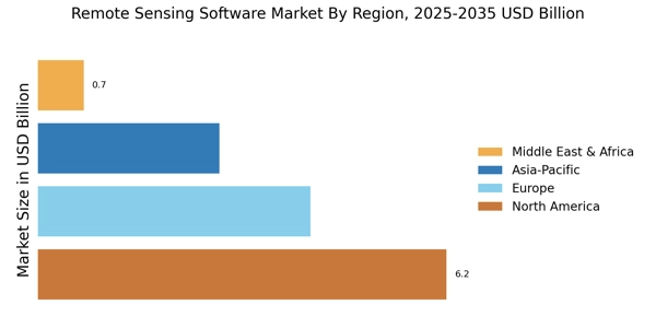
    The regional analysis of the market shows that North America dominated the market in 2023 with a revenue share of 38.2%, followed by Europe with 29.4% and APAC with 25.1%. South America and MEA accounted for 4.6% and 2.7% of the market revenue, respectively. The growth of the North American market is attributed to the increasing adoption of remote sensing technologies in various industries, such as agriculture, forestry, and environmental monitoring. The presence of major players, such as Esri, Harris Geospatial Solutions, and Hexagon AB, further contributes to the growth of the market in this region.

    The European market is also growing rapidly, driven by the increasing demand for remote sensing data in applications such as land use planning, disaster management, and climate change monitoring. The presence of key players, such as Airbus, Thales Group, and MDA, is also driving the growth of the market in this region. The APAC market is expected to witness significant growth in the coming years, due to the increasing adoption of remote sensing technologies in emerging economies, such as China, India, and Southeast Asia.

    The growing demand for remote sensing data in sectors such as agriculture, mining, and infrastructure development is also driving the growth of the market in this region.

    South America and MEA are expected to grow at a moderate pace during the forecast period. However, the growth in these regions is expected to be hindered by factors such as limited awareness about remote sensing technologies and a lack of skilled professionals.

    Fig 3: Remote Sensing Software Market Regional Insights

    Remote Sensing Software Market Regional Insights

    Source: Primary Research, Secondary Research, Market Research Future Database and Analyst Review

    Key Players and Competitive Insights

    Major players in the remote sensing software market are constantly striving to gain a competitive edge through strategic partnerships, acquisitions, and product innovations. Leading remote sensing software market players are focusing on developing advanced solutions that cater to the evolving needs of various end-use industries. The remote sensing software market competitive landscape is characterized by a mix of established players and emerging start-ups, each offering unique capabilities and solutions. Key factors driving competition include technological advancements, data security concerns, and the increasing demand for real-time and accurate data analysis.

    Collaborations between industry leaders and research institutions are also shaping the competitive dynamics of the remote sensing software market development.

    Hexagon AB, a leading provider of sensors, software, and autonomous solutions, holds a significant position in the remote sensing software market. The company offers a comprehensive suite of remote sensing solutions under its Geospatial division, including ERDAS IMAGINE, Leica Geosystems, and Intergraph. Hexagon's strength lies in its advanced image processing capabilities, data management tools, and expertise in photogrammetry and LiDAR technology. The company caters to a wide range of industries, including agriculture, defense, and environmental monitoring. Hexagon's commitment to innovation and customer support has solidified its position as a key player in the remote sensing software market.

    Airbus, a global leader in aerospace and defense, is another prominent player in the remote sensing software market. The company's Intelligence division provides a range of remote sensing software solutions, including SPOT Image, Pléiades, and TerraSAR-X. Airbus leverages its expertise in satellite imagery, radar technology, and data analytics to offer advanced solutions for land use planning, disaster management, and environmental monitoring. The company's strong partnerships with government agencies and commercial organizations have contributed to its growth in the remote sensing software market.

    Airbus continues to invest in research and development to maintain its competitive advantage and meet the evolving needs of its customers.

    Key Companies in the Remote Sensing Software Market market include

    Industry Developments

    The increasing adoption of remote sensing technologies across diverse sectors, including agriculture, forestry, environmental monitoring, and disaster management, is driving the market expansion. Moreover, advancements in cloud computing, artificial intelligence, and machine learning are further enhancing the capabilities of remote sensing software, making it more accessible and efficient for end-users. Key industry participants are focusing on strategic partnerships, acquisitions, and product innovations to gain a competitive edge in the market. Recent developments include the launch of new software platforms, integration of AI algorithms for improved data analysis, and collaborations with industry leaders to provide comprehensive solutions to customers.

    Future Outlook

    Remote Sensing Software Market Future Outlook

    The Remote Sensing Software Market is projected to grow at a 13.54% CAGR from 2024 to 2035, driven by advancements in satellite technology, increasing demand for geospatial data, and environmental monitoring needs.

    New opportunities lie in:

    • Develop AI-driven analytics tools for enhanced data interpretation.
    • Expand cloud-based platforms for real-time data access and collaboration.
    • Create tailored solutions for agriculture and urban planning sectors.

    By 2035, the Remote Sensing Software Market is expected to achieve substantial growth, reflecting its critical role in various industries.

    Market Segmentation

    Remote Sensing Software Market Regional Outlook

    • North America
    • Europe
    • South America
    • Asia Pacific
    • Middle East and Africa

    Remote Sensing Software Market Application Outlook

    • Land Cover Mapping
    • Precision Agriculture
    • Forestry Management
    • Disaster Management
    • Water Resource Management

    Remote Sensing Software Market Data Source Outlook

    • Satellite Imagery
    • Aerial Imagery
    • Drones
    • Radar
    • LiDAR

    Remote Sensing Software Market Deployment Type Outlook

    • Cloud-Based
    • On-Premises

    Remote Sensing Software Market End-User Industry Outlook

    • Agriculture
    • Mining
    • Oil and Gas
    • Transportation
    • Construction

    Report Scope

    Report Attribute/Metric Details
    Market Size 2024 13.86 (USD Billion)
    Market Size 2025 15.74 (USD Billion)
    Market Size 2034 49.41 (USD Billion)
    Compound Annual Growth Rate (CAGR) 13.55% (2025 - 2034)
    Report Coverage Revenue Forecast, Competitive Landscape, Growth Factors, and Trends
    Base Year 2024
    Market Forecast Period 2025 - 2034
    Historical Data 2019 - 2023
    Market Forecast Units USD Billion
    Key Companies Profiled Esri, Planet Labs, Airbus Defence and Space, Bentley Systems, Incorporated, Maxar Technologies, COMAP, Terrascan, Dassault Systemes, Topcon Positioning Systems Inc., Satimaging Corporation, Harris Geospatial Solutions, PCI Geomatics, Leonardo DRS, Hexagon AB, Trimble Inc.
    Segments Covered Application, Deployment Type, Data Source, End-User Industry, Regional
    Key Market Opportunities AI-driven data analysis Integration with cloud and big data platforms Advanced visualization and analytics capabilities Expansion into emerging markets Growing adoption in agriculture and environmental monitoring
    Key Market Dynamics Growing demand for geospatial data, technological advancements, increasing government initiatives, environmental monitoring, and infrastructure development
    Countries Covered North America, Europe, APAC, South America, MEA

    Market Highlights

    Author
    Ankit Gupta
    Senior Research Analyst

    Ankit Gupta is an analyst in market research industry in ICT and SEMI industry. With post-graduation in "Telecom and Marketing Management" and graduation in "Electronics and Telecommunication" vertical he is well versed with recent development in ICT industry as a whole. Having worked on more than 150+ reports including consultation for fortune 500 companies such as Microsoft and Rio Tinto in identifying solutions with respect to business problems his opinions are inclined towards mixture of technical and managerial aspects.

    Leave a Comment

    FAQs

    What is the expected CAGR of the global remote sensing software market?

    The CAGR of the global remote sensing software market is expected to be 13.55% from 2025 to 2034.

    What is the expected overall valuation of the global remote sensing software market in 2034?

    The overall valuation of the global remote sensing software market is expected to reach USD 49.41 billion by 2034.

    What is the expected overall valuation of the global remote sensing software market in 2025?

    The overall valuation of the global remote sensing software market is expected to reach USD 18.68 billion by 2025.

    Which region is expected to hold the largest market share in the global remote sensing software market?

    North America is expected to hold the largest market share in the global remote sensing software market throughout the forecast period.

    Which application segment is expected to hold the largest market share in the global remote sensing software market?

    The agriculture segment is expected to hold the largest market share in the global remote sensing software market throughout the forecast period.

    Who are some of the key competitors in the global remote sensing software market?

    Some of the key competitors in the global remote sensing software market include Esri, Hexagon, Trimble, and Airbus.

    What are some of the key trends in the global remote sensing software market?

    Some of the key trends in the global remote sensing software market include the increasing adoption of cloud-based solutions and the growing demand for real-time data analytics.

    What are some of the challenges facing the global remote sensing software market?

    Some of the challenges facing the global remote sensing software market include the high cost of implementation and the lack of skilled professionals.

    What are some of the opportunities for the global remote sensing software market?

    Some of the opportunities for the global remote sensing software market include the growing demand for precision agriculture and the increasing use of remote sensing data in disaster management.

    What was the market size of the global remote sensing software market in 2023?

    The global remote sensing software market reached USD 12.21 billion in 2023.

    1. EXECUTIVE SUMMARY
    2. Market Overview
    3. Key Findings
    4. Market Segmentation
    5. Competitive Landscape
    6. Challenges and Opportunities
    7. Future Outlook
    8. MARKET INTRODUCTION
    9. Definition
    10. Scope of the study
    11. Research Objective
    12. Assumption
    13. Limitations
    14. RESEARCH METHODOLOGY
    15. Overview
    16. Data Mining
    17. Secondary Research
    18. Primary Research
    19. Primary Interviews and Information Gathering Process
    20. Breakdown of Primary Respondents
    21. Forecasting Model
    22. Market Size Estimation
    23. Bottom-Up Approach
    24. Top-Down Approach
    25. Data Triangulation
    26. Validation
    27. MARKET DYNAMICS
    28. Overview
    29. Drivers
    30. Restraints
    31. Opportunities
    32. MARKET FACTOR ANALYSIS
    33. Value chain Analysis
    34. Porter's Five Forces Analysis
    35. Bargaining Power of Suppliers
    36. Bargaining Power of Buyers
    37. Threat of New Entrants
    38. Threat of Substitutes
    39. Intensity of Rivalry
    40. COVID-19 Impact Analysis
    41. Market Impact Analysis
    42. Regional Impact
    43. Opportunity and Threat Analysis
    44. Remote Sensing Software Market, BY Application (USD Billion)
    45. Land Cover Mapping
    46. Precision Agriculture
    47. Forestry Management
    48. Disaster Management
    49. Water Resource Management
    50. Remote Sensing Software Market, BY Deployment Type (USD Billion)
    51. Cloud-Based
    52. On-Premises
    53. Remote Sensing Software Market, BY Data Source (USD Billion)
    54. Satellite Imagery
    55. Aerial Imagery
    56. Drones
    57. Radar
    58. LiDAR
    59. Remote Sensing Software Market, BY End-User Industry (USD Billion)
    60. Agriculture
    61. Mining
    62. Oil and Gas
    63. Transportation
    64. Construction
    65. Remote Sensing Software Market, BY Regional (USD Billion)
    66. North America
    67. US
    68. Canada
    69. Europe
    70. Germany
    71. UK
    72. France
    73. Russia
    74. Italy
    75. Spain
    76. Rest of Europe
    77. APAC
    78. China
    79. India
    80. Japan
    81. South Korea
    82. Malaysia
    83. Thailand
    84. Indonesia
    85. Rest of APAC
    86. South America
    87. Brazil
    88. Mexico
    89. Argentina
    90. Rest of South America
    91. MEA
    92. GCC Countries
    93. South Africa
    94. Rest of MEA
    95. Competitive Landscape
    96. Overview
    97. Competitive Analysis
    98. Market share Analysis
    99. Major Growth Strategy in the Remote Sensing Software Market
    100. Competitive Benchmarking
    101. Leading Players in Terms of Number of Developments in the Remote Sensing Software Market
    102. Key developments and growth strategies
    103. New Product Launch/Service Deployment
    104. Merger & Acquisitions
    105. Joint Ventures
    106. Major Players Financial Matrix
    107. Sales and Operating Income
    108. Major Players R&D Expenditure. 2023
    109. Company Profiles
    110. Esri
    111. Financial Overview
    112. Products Offered
    113. Key Developments
    114. SWOT Analysis
    115. Key Strategies
    116. Planet Labs
    117. Financial Overview
    118. Products Offered
    119. Key Developments
    120. SWOT Analysis
    121. Key Strategies
    122. Airbus Defence and Space
    123. Financial Overview
    124. Products Offered
    125. Key Developments
    126. SWOT Analysis
    127. Key Strategies
    128. Bentley Systems, Incorporated
    129. Financial Overview
    130. Products Offered
    131. Key Developments
    132. SWOT Analysis
    133. Key Strategies
    134. Maxar Technologies
    135. Financial Overview
    136. Products Offered
    137. Key Developments
    138. SWOT Analysis
    139. Key Strategies
    140. COMAP
    141. Financial Overview
    142. Products Offered
    143. Key Developments
    144. SWOT Analysis
    145. Key Strategies
    146. Terrascan
    147. Financial Overview
    148. Products Offered
    149. Key Developments
    150. SWOT Analysis
    151. Key Strategies
    152. Dassault Systemes
    153. Financial Overview
    154. Products Offered
    155. Key Developments
    156. SWOT Analysis
    157. Key Strategies
    158. Topcon Positioning Systems Inc.
    159. Financial Overview
    160. Products Offered
    161. Key Developments
    162. SWOT Analysis
    163. Key Strategies
    164. Satimaging Corporation
    165. Financial Overview
    166. Products Offered
    167. Key Developments
    168. SWOT Analysis
    169. Key Strategies
    170. Harris Geospatial Solutions
    171. Financial Overview
    172. Products Offered
    173. Key Developments
    174. SWOT Analysis
    175. Key Strategies
    176. PCI Geomatics
    177. Financial Overview
    178. Products Offered
    179. Key Developments
    180. SWOT Analysis
    181. Key Strategies
    182. Leonardo DRS
    183. Financial Overview
    184. Products Offered
    185. Key Developments
    186. SWOT Analysis
    187. Key Strategies
    188. Hexagon AB
    189. Financial Overview
    190. Products Offered
    191. Key Developments
    192. SWOT Analysis
    193. Key Strategies
    194. Trimble Inc.
    195. Financial Overview
    196. Products Offered
    197. Key Developments
    198. SWOT Analysis
    199. Key Strategies
    200. References
    201. Related Reports
    202. North America Remote Sensing Software Market SIZE ESTIMATES & FORECAST, BY APPLICATION, 2019-2032 (USD Billions)
    203. North America Remote Sensing Software Market SIZE ESTIMATES & FORECAST, BY DEPLOYMENT TYPE, 2019-2032 (USD Billions)
    204. North America Remote Sensing Software Market SIZE ESTIMATES & FORECAST, BY DATA SOURCE, 2019-2032 (USD Billions)
    205. North America Remote Sensing Software Market SIZE ESTIMATES & FORECAST, BY END-USER INDUSTRY, 2019-2032 (USD Billions)
    206. North America Remote Sensing Software Market SIZE ESTIMATES & FORECAST, BY REGIONAL, 2019-2032 (USD Billions)
    207. US Remote Sensing Software Market SIZE ESTIMATES & FORECAST, BY APPLICATION, 2019-2032 (USD Billions)
    208. US Remote Sensing Software Market SIZE ESTIMATES & FORECAST, BY DEPLOYMENT TYPE, 2019-2032 (USD Billions)
    209. US Remote Sensing Software Market SIZE ESTIMATES & FORECAST, BY DATA SOURCE, 2019-2032 (USD Billions)
    210. US Remote Sensing Software Market SIZE ESTIMATES & FORECAST, BY END-USER INDUSTRY, 2019-2032 (USD Billions)
    211. US Remote Sensing Software Market SIZE ESTIMATES & FORECAST, BY REGIONAL, 2019-2032 (USD Billions)
    212. Canada Remote Sensing Software Market SIZE ESTIMATES & FORECAST, BY APPLICATION, 2019-2032 (USD Billions)
    213. Canada Remote Sensing Software Market SIZE ESTIMATES & FORECAST, BY DEPLOYMENT TYPE, 2019-2032 (USD Billions)
    214. Canada Remote Sensing Software Market SIZE ESTIMATES & FORECAST, BY DATA SOURCE, 2019-2032 (USD Billions)
    215. Canada Remote Sensing Software Market SIZE ESTIMATES & FORECAST, BY END-USER INDUSTRY, 2019-2032 (USD Billions)
    216. Canada Remote Sensing Software Market SIZE ESTIMATES & FORECAST, BY REGIONAL, 2019-2032 (USD Billions)
    217. Europe Remote Sensing Software Market SIZE ESTIMATES & FORECAST, BY APPLICATION, 2019-2032 (USD Billions)
    218. Europe Remote Sensing Software Market SIZE ESTIMATES & FORECAST, BY DEPLOYMENT TYPE, 2019-2032 (USD Billions)
    219. Europe Remote Sensing Software Market SIZE ESTIMATES & FORECAST, BY DATA SOURCE, 2019-2032 (USD Billions)
    220. Europe Remote Sensing Software Market SIZE ESTIMATES & FORECAST, BY END-USER INDUSTRY, 2019-2032 (USD Billions)
    221. Europe Remote Sensing Software Market SIZE ESTIMATES & FORECAST, BY REGIONAL, 2019-2032 (USD Billions)
    222. Germany Remote Sensing Software Market SIZE ESTIMATES & FORECAST, BY APPLICATION, 2019-2032 (USD Billions)
    223. Germany Remote Sensing Software Market SIZE ESTIMATES & FORECAST, BY DEPLOYMENT TYPE, 2019-2032 (USD Billions)
    224. Germany Remote Sensing Software Market SIZE ESTIMATES & FORECAST, BY DATA SOURCE, 2019-2032 (USD Billions)
    225. Germany Remote Sensing Software Market SIZE ESTIMATES & FORECAST, BY END-USER INDUSTRY, 2019-2032 (USD Billions)
    226. Germany Remote Sensing Software Market SIZE ESTIMATES & FORECAST, BY REGIONAL, 2019-2032 (USD Billions)
    227. UK Remote Sensing Software Market SIZE ESTIMATES & FORECAST, BY APPLICATION, 2019-2032 (USD Billions)
    228. UK Remote Sensing Software Market SIZE ESTIMATES & FORECAST, BY DEPLOYMENT TYPE, 2019-2032 (USD Billions)
    229. UK Remote Sensing Software Market SIZE ESTIMATES & FORECAST, BY DATA SOURCE, 2019-2032 (USD Billions)
    230. UK Remote Sensing Software Market SIZE ESTIMATES & FORECAST, BY END-USER INDUSTRY, 2019-2032 (USD Billions)
    231. UK Remote Sensing Software Market SIZE ESTIMATES & FORECAST, BY REGIONAL, 2019-2032 (USD Billions)
    232. France Remote Sensing Software Market SIZE ESTIMATES & FORECAST, BY APPLICATION, 2019-2032 (USD Billions)
    233. France Remote Sensing Software Market SIZE ESTIMATES & FORECAST, BY DEPLOYMENT TYPE, 2019-2032 (USD Billions)
    234. France Remote Sensing Software Market SIZE ESTIMATES & FORECAST, BY DATA SOURCE, 2019-2032 (USD Billions)
    235. France Remote Sensing Software Market SIZE ESTIMATES & FORECAST, BY END-USER INDUSTRY, 2019-2032 (USD Billions)
    236. France Remote Sensing Software Market SIZE ESTIMATES & FORECAST, BY REGIONAL, 2019-2032 (USD Billions)
    237. Russia Remote Sensing Software Market SIZE ESTIMATES & FORECAST, BY APPLICATION, 2019-2032 (USD Billions)
    238. Russia Remote Sensing Software Market SIZE ESTIMATES & FORECAST, BY DEPLOYMENT TYPE, 2019-2032 (USD Billions)
    239. Russia Remote Sensing Software Market SIZE ESTIMATES & FORECAST, BY DATA SOURCE, 2019-2032 (USD Billions)
    240. Russia Remote Sensing Software Market SIZE ESTIMATES & FORECAST, BY END-USER INDUSTRY, 2019-2032 (USD Billions)
    241. Russia Remote Sensing Software Market SIZE ESTIMATES & FORECAST, BY REGIONAL, 2019-2032 (USD Billions)
    242. Italy Remote Sensing Software Market SIZE ESTIMATES & FORECAST, BY APPLICATION, 2019-2032 (USD Billions)
    243. Italy Remote Sensing Software Market SIZE ESTIMATES & FORECAST, BY DEPLOYMENT TYPE, 2019-2032 (USD Billions)
    244. Italy Remote Sensing Software Market SIZE ESTIMATES & FORECAST, BY DATA SOURCE, 2019-2032 (USD Billions)
    245. Italy Remote Sensing Software Market SIZE ESTIMATES & FORECAST, BY END-USER INDUSTRY, 2019-2032 (USD Billions)
    246. Italy Remote Sensing Software Market SIZE ESTIMATES & FORECAST, BY REGIONAL, 2019-2032 (USD Billions)
    247. Spain Remote Sensing Software Market SIZE ESTIMATES & FORECAST, BY APPLICATION, 2019-2032 (USD Billions)
    248. Spain Remote Sensing Software Market SIZE ESTIMATES & FORECAST, BY DEPLOYMENT TYPE, 2019-2032 (USD Billions)
    249. Spain Remote Sensing Software Market SIZE ESTIMATES & FORECAST, BY DATA SOURCE, 2019-2032 (USD Billions)
    250. Spain Remote Sensing Software Market SIZE ESTIMATES & FORECAST, BY END-USER INDUSTRY, 2019-2032 (USD Billions)
    251. Spain Remote Sensing Software Market SIZE ESTIMATES & FORECAST, BY REGIONAL, 2019-2032 (USD Billions)
    252. Rest of Europe Remote Sensing Software Market SIZE ESTIMATES & FORECAST, BY APPLICATION, 2019-2032 (USD Billions)
    253. Rest of Europe Remote Sensing Software Market SIZE ESTIMATES & FORECAST, BY DEPLOYMENT TYPE, 2019-2032 (USD Billions)
    254. Rest of Europe Remote Sensing Software Market SIZE ESTIMATES & FORECAST, BY DATA SOURCE, 2019-2032 (USD Billions)
    255. Rest of Europe Remote Sensing Software Market SIZE ESTIMATES & FORECAST, BY END-USER INDUSTRY, 2019-2032 (USD Billions)
    256. Rest of Europe Remote Sensing Software Market SIZE ESTIMATES & FORECAST, BY REGIONAL, 2019-2032 (USD Billions)
    257. APAC Remote Sensing Software Market SIZE ESTIMATES & FORECAST, BY APPLICATION, 2019-2032 (USD Billions)
    258. APAC Remote Sensing Software Market SIZE ESTIMATES & FORECAST, BY DEPLOYMENT TYPE, 2019-2032 (USD Billions)
    259. APAC Remote Sensing Software Market SIZE ESTIMATES & FORECAST, BY DATA SOURCE, 2019-2032 (USD Billions)
    260. APAC Remote Sensing Software Market SIZE ESTIMATES & FORECAST, BY END-USER INDUSTRY, 2019-2032 (USD Billions)
    261. APAC Remote Sensing Software Market SIZE ESTIMATES & FORECAST, BY REGIONAL, 2019-2032 (USD Billions)
    262. China Remote Sensing Software Market SIZE ESTIMATES & FORECAST, BY APPLICATION, 2019-2032 (USD Billions)
    263. China Remote Sensing Software Market SIZE ESTIMATES & FORECAST, BY DEPLOYMENT TYPE, 2019-2032 (USD Billions)
    264. China Remote Sensing Software Market SIZE ESTIMATES & FORECAST, BY DATA SOURCE, 2019-2032 (USD Billions)
    265. China Remote Sensing Software Market SIZE ESTIMATES & FORECAST, BY END-USER INDUSTRY, 2019-2032 (USD Billions)
    266. China Remote Sensing Software Market SIZE ESTIMATES & FORECAST, BY REGIONAL, 2019-2032 (USD Billions)
    267. India Remote Sensing Software Market SIZE ESTIMATES & FORECAST, BY APPLICATION, 2019-2032 (USD Billions)
    268. India Remote Sensing Software Market SIZE ESTIMATES & FORECAST, BY DEPLOYMENT TYPE, 2019-2032 (USD Billions)
    269. India Remote Sensing Software Market SIZE ESTIMATES & FORECAST, BY DATA SOURCE, 2019-2032 (USD Billions)
    270. India Remote Sensing Software Market SIZE ESTIMATES & FORECAST, BY END-USER INDUSTRY, 2019-2032 (USD Billions)
    271. India Remote Sensing Software Market SIZE ESTIMATES & FORECAST, BY REGIONAL, 2019-2032 (USD Billions)
    272. Japan Remote Sensing Software Market SIZE ESTIMATES & FORECAST, BY APPLICATION, 2019-2032 (USD Billions)
    273. Japan Remote Sensing Software Market SIZE ESTIMATES & FORECAST, BY DEPLOYMENT TYPE, 2019-2032 (USD Billions)
    274. Japan Remote Sensing Software Market SIZE ESTIMATES & FORECAST, BY DATA SOURCE, 2019-2032 (USD Billions)
    275. Japan Remote Sensing Software Market SIZE ESTIMATES & FORECAST, BY END-USER INDUSTRY, 2019-2032 (USD Billions)
    276. Japan Remote Sensing Software Market SIZE ESTIMATES & FORECAST, BY REGIONAL, 2019-2032 (USD Billions)
    277. South Korea Remote Sensing Software Market SIZE ESTIMATES & FORECAST, BY APPLICATION, 2019-2032 (USD Billions)
    278. South Korea Remote Sensing Software Market SIZE ESTIMATES & FORECAST, BY DEPLOYMENT TYPE, 2019-2032 (USD Billions)
    279. South Korea Remote Sensing Software Market SIZE ESTIMATES & FORECAST, BY DATA SOURCE, 2019-2032 (USD Billions)
    280. South Korea Remote Sensing Software Market SIZE ESTIMATES & FORECAST, BY END-USER INDUSTRY, 2019-2032 (USD Billions)
    281. South Korea Remote Sensing Software Market SIZE ESTIMATES & FORECAST, BY REGIONAL, 2019-2032 (USD Billions)
    282. Malaysia Remote Sensing Software Market SIZE ESTIMATES & FORECAST, BY APPLICATION, 2019-2032 (USD Billions)
    283. Malaysia Remote Sensing Software Market SIZE ESTIMATES & FORECAST, BY DEPLOYMENT TYPE, 2019-2032 (USD Billions)
    284. Malaysia Remote Sensing Software Market SIZE ESTIMATES & FORECAST, BY DATA SOURCE, 2019-2032 (USD Billions)
    285. Malaysia Remote Sensing Software Market SIZE ESTIMATES & FORECAST, BY END-USER INDUSTRY, 2019-2032 (USD Billions)
    286. Malaysia Remote Sensing Software Market SIZE ESTIMATES & FORECAST, BY REGIONAL, 2019-2032 (USD Billions)
    287. Thailand Remote Sensing Software Market SIZE ESTIMATES & FORECAST, BY APPLICATION, 2019-2032 (USD Billions)
    288. Thailand Remote Sensing Software Market SIZE ESTIMATES & FORECAST, BY DEPLOYMENT TYPE, 2019-2032 (USD Billions)
    289. Thailand Remote Sensing Software Market SIZE ESTIMATES & FORECAST, BY DATA SOURCE, 2019-2032 (USD Billions)
    290. Thailand Remote Sensing Software Market SIZE ESTIMATES & FORECAST, BY END-USER INDUSTRY, 2019-2032 (USD Billions)
    291. Thailand Remote Sensing Software Market SIZE ESTIMATES & FORECAST, BY REGIONAL, 2019-2032 (USD Billions)
    292. Indonesia Remote Sensing Software Market SIZE ESTIMATES & FORECAST, BY APPLICATION, 2019-2032 (USD Billions)
    293. Indonesia Remote Sensing Software Market SIZE ESTIMATES & FORECAST, BY DEPLOYMENT TYPE, 2019-2032 (USD Billions)
    294. Indonesia Remote Sensing Software Market SIZE ESTIMATES & FORECAST, BY DATA SOURCE, 2019-2032 (USD Billions)
    295. Indonesia Remote Sensing Software Market SIZE ESTIMATES & FORECAST, BY END-USER INDUSTRY, 2019-2032 (USD Billions)
    296. Indonesia Remote Sensing Software Market SIZE ESTIMATES & FORECAST, BY REGIONAL, 2019-2032 (USD Billions)
    297. Rest of APAC Remote Sensing Software Market SIZE ESTIMATES & FORECAST, BY APPLICATION, 2019-2032 (USD Billions)
    298. Rest of APAC Remote Sensing Software Market SIZE ESTIMATES & FORECAST, BY DEPLOYMENT TYPE, 2019-2032 (USD Billions)
    299. Rest of APAC Remote Sensing Software Market SIZE ESTIMATES & FORECAST, BY DATA SOURCE, 2019-2032 (USD Billions)
    300. Rest of APAC Remote Sensing Software Market SIZE ESTIMATES & FORECAST, BY END-USER INDUSTRY, 2019-2032 (USD Billions)
    301. Rest of APAC Remote Sensing Software Market SIZE ESTIMATES & FORECAST, BY REGIONAL, 2019-2032 (USD Billions)
    302. South America Remote Sensing Software Market SIZE ESTIMATES & FORECAST, BY APPLICATION, 2019-2032 (USD Billions)
    303. South America Remote Sensing Software Market SIZE ESTIMATES & FORECAST, BY DEPLOYMENT TYPE, 2019-2032 (USD Billions)
    304. South America Remote Sensing Software Market SIZE ESTIMATES & FORECAST, BY DATA SOURCE, 2019-2032 (USD Billions)
    305. South America Remote Sensing Software Market SIZE ESTIMATES & FORECAST, BY END-USER INDUSTRY, 2019-2032 (USD Billions)
    306. South America Remote Sensing Software Market SIZE ESTIMATES & FORECAST, BY REGIONAL, 2019-2032 (USD Billions)
    307. Brazil Remote Sensing Software Market SIZE ESTIMATES & FORECAST, BY APPLICATION, 2019-2032 (USD Billions)
    308. Brazil Remote Sensing Software Market SIZE ESTIMATES & FORECAST, BY DEPLOYMENT TYPE, 2019-2032 (USD Billions)
    309. Brazil Remote Sensing Software Market SIZE ESTIMATES & FORECAST, BY DATA SOURCE, 2019-2032 (USD Billions)
    310. Brazil Remote Sensing Software Market SIZE ESTIMATES & FORECAST, BY END-USER INDUSTRY, 2019-2032 (USD Billions)
    311. Brazil Remote Sensing Software Market SIZE ESTIMATES & FORECAST, BY REGIONAL, 2019-2032 (USD Billions)
    312. Mexico Remote Sensing Software Market SIZE ESTIMATES & FORECAST, BY APPLICATION, 2019-2032 (USD Billions)
    313. Mexico Remote Sensing Software Market SIZE ESTIMATES & FORECAST, BY DEPLOYMENT TYPE, 2019-2032 (USD Billions)
    314. Mexico Remote Sensing Software Market SIZE ESTIMATES & FORECAST, BY DATA SOURCE, 2019-2032 (USD Billions)
    315. Mexico Remote Sensing Software Market SIZE ESTIMATES & FORECAST, BY END-USER INDUSTRY, 2019-2032 (USD Billions)
    316. Mexico Remote Sensing Software Market SIZE ESTIMATES & FORECAST, BY REGIONAL, 2019-2032 (USD Billions)
    317. Argentina Remote Sensing Software Market SIZE ESTIMATES & FORECAST, BY APPLICATION, 2019-2032 (USD Billions)
    318. Argentina Remote Sensing Software Market SIZE ESTIMATES & FORECAST, BY DEPLOYMENT TYPE, 2019-2032 (USD Billions)
    319. Argentina Remote Sensing Software Market SIZE ESTIMATES & FORECAST, BY DATA SOURCE, 2019-2032 (USD Billions)
    320. Argentina Remote Sensing Software Market SIZE ESTIMATES & FORECAST, BY END-USER INDUSTRY, 2019-2032 (USD Billions)
    321. Argentina Remote Sensing Software Market SIZE ESTIMATES & FORECAST, BY REGIONAL, 2019-2032 (USD Billions)
    322. Rest of South America Remote Sensing Software Market SIZE ESTIMATES & FORECAST, BY APPLICATION, 2019-2032 (USD Billions)
    323. Rest of South America Remote Sensing Software Market SIZE ESTIMATES & FORECAST, BY DEPLOYMENT TYPE, 2019-2032 (USD Billions)
    324. Rest of South America Remote Sensing Software Market SIZE ESTIMATES & FORECAST, BY DATA SOURCE, 2019-2032 (USD Billions)
    325. Rest of South America Remote Sensing Software Market SIZE ESTIMATES & FORECAST, BY END-USER INDUSTRY, 2019-2032 (USD Billions)
    326. Rest of South America Remote Sensing Software Market SIZE ESTIMATES & FORECAST, BY REGIONAL, 2019-2032 (USD Billions)
    327. MEA Remote Sensing Software Market SIZE ESTIMATES & FORECAST, BY APPLICATION, 2019-2032 (USD Billions)
    328. MEA Remote Sensing Software Market SIZE ESTIMATES & FORECAST, BY DEPLOYMENT TYPE, 2019-2032 (USD Billions)
    329. MEA Remote Sensing Software Market SIZE ESTIMATES & FORECAST, BY DATA SOURCE, 2019-2032 (USD Billions)
    330. MEA Remote Sensing Software Market SIZE ESTIMATES & FORECAST, BY END-USER INDUSTRY, 2019-2032 (USD Billions)
    331. MEA Remote Sensing Software Market SIZE ESTIMATES & FORECAST, BY REGIONAL, 2019-2032 (USD Billions)
    332. GCC Countries Remote Sensing Software Market SIZE ESTIMATES & FORECAST, BY APPLICATION, 2019-2032 (USD Billions)
    333. GCC Countries Remote Sensing Software Market SIZE ESTIMATES & FORECAST, BY DEPLOYMENT TYPE, 2019-2032 (USD Billions)
    334. GCC Countries Remote Sensing Software Market SIZE ESTIMATES & FORECAST, BY DATA SOURCE, 2019-2032 (USD Billions)
    335. GCC Countries Remote Sensing Software Market SIZE ESTIMATES & FORECAST, BY END-USER INDUSTRY, 2019-2032 (USD Billions)
    336. GCC Countries Remote Sensing Software Market SIZE ESTIMATES & FORECAST, BY REGIONAL, 2019-2032 (USD Billions)
    337. South Africa Remote Sensing Software Market SIZE ESTIMATES & FORECAST, BY APPLICATION, 2019-2032 (USD Billions)
    338. South Africa Remote Sensing Software Market SIZE ESTIMATES & FORECAST, BY DEPLOYMENT TYPE, 2019-2032 (USD Billions)
    339. South Africa Remote Sensing Software Market SIZE ESTIMATES & FORECAST, BY DATA SOURCE, 2019-2032 (USD Billions)
    340. South Africa Remote Sensing Software Market SIZE ESTIMATES & FORECAST, BY END-USER INDUSTRY, 2019-2032 (USD Billions)
    341. South Africa Remote Sensing Software Market SIZE ESTIMATES & FORECAST, BY REGIONAL, 2019-2032 (USD Billions)
    342. Rest of MEA Remote Sensing Software Market SIZE ESTIMATES & FORECAST, BY APPLICATION, 2019-2032 (USD Billions)
    343. Rest of MEA Remote Sensing Software Market SIZE ESTIMATES & FORECAST, BY DEPLOYMENT TYPE, 2019-2032 (USD Billions)
    344. Rest of MEA Remote Sensing Software Market SIZE ESTIMATES & FORECAST, BY DATA SOURCE, 2019-2032 (USD Billions)
    345. Rest of MEA Remote Sensing Software Market SIZE ESTIMATES & FORECAST, BY END-USER INDUSTRY, 2019-2032 (USD Billions)
    346. Rest of MEA Remote Sensing Software Market SIZE ESTIMATES & FORECAST, BY REGIONAL, 2019-2032 (USD Billions)
    347. PRODUCT LAUNCH/PRODUCT DEVELOPMENT/APPROVAL
    348. ACQUISITION/PARTNERSHIP
    349. MARKET SYNOPSIS
    350. NORTH AMERICA REMOTE SENSING SOFTWARE MARKET ANALYSIS
    351. US REMOTE SENSING SOFTWARE MARKET ANALYSIS BY APPLICATION
    352. US REMOTE SENSING SOFTWARE MARKET ANALYSIS BY DEPLOYMENT TYPE
    353. US REMOTE SENSING SOFTWARE MARKET ANALYSIS BY DATA SOURCE
    354. US REMOTE SENSING SOFTWARE MARKET ANALYSIS BY END-USER INDUSTRY
    355. US REMOTE SENSING SOFTWARE MARKET ANALYSIS BY REGIONAL
    356. CANADA REMOTE SENSING SOFTWARE MARKET ANALYSIS BY APPLICATION
    357. CANADA REMOTE SENSING SOFTWARE MARKET ANALYSIS BY DEPLOYMENT TYPE
    358. CANADA REMOTE SENSING SOFTWARE MARKET ANALYSIS BY DATA SOURCE
    359. CANADA REMOTE SENSING SOFTWARE MARKET ANALYSIS BY END-USER INDUSTRY
    360. CANADA REMOTE SENSING SOFTWARE MARKET ANALYSIS BY REGIONAL
    361. EUROPE REMOTE SENSING SOFTWARE MARKET ANALYSIS
    362. GERMANY REMOTE SENSING SOFTWARE MARKET ANALYSIS BY APPLICATION
    363. GERMANY REMOTE SENSING SOFTWARE MARKET ANALYSIS BY DEPLOYMENT TYPE
    364. GERMANY REMOTE SENSING SOFTWARE MARKET ANALYSIS BY DATA SOURCE
    365. GERMANY REMOTE SENSING SOFTWARE MARKET ANALYSIS BY END-USER INDUSTRY
    366. GERMANY REMOTE SENSING SOFTWARE MARKET ANALYSIS BY REGIONAL
    367. UK REMOTE SENSING SOFTWARE MARKET ANALYSIS BY APPLICATION
    368. UK REMOTE SENSING SOFTWARE MARKET ANALYSIS BY DEPLOYMENT TYPE
    369. UK REMOTE SENSING SOFTWARE MARKET ANALYSIS BY DATA SOURCE
    370. UK REMOTE SENSING SOFTWARE MARKET ANALYSIS BY END-USER INDUSTRY
    371. UK REMOTE SENSING SOFTWARE MARKET ANALYSIS BY REGIONAL
    372. FRANCE REMOTE SENSING SOFTWARE MARKET ANALYSIS BY APPLICATION
    373. FRANCE REMOTE SENSING SOFTWARE MARKET ANALYSIS BY DEPLOYMENT TYPE
    374. FRANCE REMOTE SENSING SOFTWARE MARKET ANALYSIS BY DATA SOURCE
    375. FRANCE REMOTE SENSING SOFTWARE MARKET ANALYSIS BY END-USER INDUSTRY
    376. FRANCE REMOTE SENSING SOFTWARE MARKET ANALYSIS BY REGIONAL
    377. RUSSIA REMOTE SENSING SOFTWARE MARKET ANALYSIS BY APPLICATION
    378. RUSSIA REMOTE SENSING SOFTWARE MARKET ANALYSIS BY DEPLOYMENT TYPE
    379. RUSSIA REMOTE SENSING SOFTWARE MARKET ANALYSIS BY DATA SOURCE
    380. RUSSIA REMOTE SENSING SOFTWARE MARKET ANALYSIS BY END-USER INDUSTRY
    381. RUSSIA REMOTE SENSING SOFTWARE MARKET ANALYSIS BY REGIONAL
    382. ITALY REMOTE SENSING SOFTWARE MARKET ANALYSIS BY APPLICATION
    383. ITALY REMOTE SENSING SOFTWARE MARKET ANALYSIS BY DEPLOYMENT TYPE
    384. ITALY REMOTE SENSING SOFTWARE MARKET ANALYSIS BY DATA SOURCE
    385. ITALY REMOTE SENSING SOFTWARE MARKET ANALYSIS BY END-USER INDUSTRY
    386. ITALY REMOTE SENSING SOFTWARE MARKET ANALYSIS BY REGIONAL
    387. SPAIN REMOTE SENSING SOFTWARE MARKET ANALYSIS BY APPLICATION
    388. SPAIN REMOTE SENSING SOFTWARE MARKET ANALYSIS BY DEPLOYMENT TYPE
    389. SPAIN REMOTE SENSING SOFTWARE MARKET ANALYSIS BY DATA SOURCE
    390. SPAIN REMOTE SENSING SOFTWARE MARKET ANALYSIS BY END-USER INDUSTRY
    391. SPAIN REMOTE SENSING SOFTWARE MARKET ANALYSIS BY REGIONAL
    392. REST OF EUROPE REMOTE SENSING SOFTWARE MARKET ANALYSIS BY APPLICATION
    393. REST OF EUROPE REMOTE SENSING SOFTWARE MARKET ANALYSIS BY DEPLOYMENT TYPE
    394. REST OF EUROPE REMOTE SENSING SOFTWARE MARKET ANALYSIS BY DATA SOURCE
    395. REST OF EUROPE REMOTE SENSING SOFTWARE MARKET ANALYSIS BY END-USER INDUSTRY
    396. REST OF EUROPE REMOTE SENSING SOFTWARE MARKET ANALYSIS BY REGIONAL
    397. APAC REMOTE SENSING SOFTWARE MARKET ANALYSIS
    398. CHINA REMOTE SENSING SOFTWARE MARKET ANALYSIS BY APPLICATION
    399. CHINA REMOTE SENSING SOFTWARE MARKET ANALYSIS BY DEPLOYMENT TYPE
    400. CHINA REMOTE SENSING SOFTWARE MARKET ANALYSIS BY DATA SOURCE
    401. CHINA REMOTE SENSING SOFTWARE MARKET ANALYSIS BY END-USER INDUSTRY
    402. CHINA REMOTE SENSING SOFTWARE MARKET ANALYSIS BY REGIONAL
    403. INDIA REMOTE SENSING SOFTWARE MARKET ANALYSIS BY APPLICATION
    404. INDIA REMOTE SENSING SOFTWARE MARKET ANALYSIS BY DEPLOYMENT TYPE
    405. INDIA REMOTE SENSING SOFTWARE MARKET ANALYSIS BY DATA SOURCE
    406. INDIA REMOTE SENSING SOFTWARE MARKET ANALYSIS BY END-USER INDUSTRY
    407. INDIA REMOTE SENSING SOFTWARE MARKET ANALYSIS BY REGIONAL
    408. JAPAN REMOTE SENSING SOFTWARE MARKET ANALYSIS BY APPLICATION
    409. JAPAN REMOTE SENSING SOFTWARE MARKET ANALYSIS BY DEPLOYMENT TYPE
    410. JAPAN REMOTE SENSING SOFTWARE MARKET ANALYSIS BY DATA SOURCE
    411. JAPAN REMOTE SENSING SOFTWARE MARKET ANALYSIS BY END-USER INDUSTRY
    412. JAPAN REMOTE SENSING SOFTWARE MARKET ANALYSIS BY REGIONAL
    413. SOUTH KOREA REMOTE SENSING SOFTWARE MARKET ANALYSIS BY APPLICATION
    414. SOUTH KOREA REMOTE SENSING SOFTWARE MARKET ANALYSIS BY DEPLOYMENT TYPE
    415. SOUTH KOREA REMOTE SENSING SOFTWARE MARKET ANALYSIS BY DATA SOURCE
    416. SOUTH KOREA REMOTE SENSING SOFTWARE MARKET ANALYSIS BY END-USER INDUSTRY
    417. SOUTH KOREA REMOTE SENSING SOFTWARE MARKET ANALYSIS BY REGIONAL
    418. MALAYSIA REMOTE SENSING SOFTWARE MARKET ANALYSIS BY APPLICATION
    419. MALAYSIA REMOTE SENSING SOFTWARE MARKET ANALYSIS BY DEPLOYMENT TYPE
    420. MALAYSIA REMOTE SENSING SOFTWARE MARKET ANALYSIS BY DATA SOURCE
    421. MALAYSIA REMOTE SENSING SOFTWARE MARKET ANALYSIS BY END-USER INDUSTRY
    422. MALAYSIA REMOTE SENSING SOFTWARE MARKET ANALYSIS BY REGIONAL
    423. THAILAND REMOTE SENSING SOFTWARE MARKET ANALYSIS BY APPLICATION
    424. THAILAND REMOTE SENSING SOFTWARE MARKET ANALYSIS BY DEPLOYMENT TYPE
    425. THAILAND REMOTE SENSING SOFTWARE MARKET ANALYSIS BY DATA SOURCE
    426. THAILAND REMOTE SENSING SOFTWARE MARKET ANALYSIS BY END-USER INDUSTRY
    427. THAILAND REMOTE SENSING SOFTWARE MARKET ANALYSIS BY REGIONAL
    428. INDONESIA REMOTE SENSING SOFTWARE MARKET ANALYSIS BY APPLICATION
    429. INDONESIA REMOTE SENSING SOFTWARE MARKET ANALYSIS BY DEPLOYMENT TYPE
    430. INDONESIA REMOTE SENSING SOFTWARE MARKET ANALYSIS BY DATA SOURCE
    431. INDONESIA REMOTE SENSING SOFTWARE MARKET ANALYSIS BY END-USER INDUSTRY
    432. INDONESIA REMOTE SENSING SOFTWARE MARKET ANALYSIS BY REGIONAL
    433. REST OF APAC REMOTE SENSING SOFTWARE MARKET ANALYSIS BY APPLICATION
    434. REST OF APAC REMOTE SENSING SOFTWARE MARKET ANALYSIS BY DEPLOYMENT TYPE
    435. REST OF APAC REMOTE SENSING SOFTWARE MARKET ANALYSIS BY DATA SOURCE
    436. REST OF APAC REMOTE SENSING SOFTWARE MARKET ANALYSIS BY END-USER INDUSTRY
    437. REST OF APAC REMOTE SENSING SOFTWARE MARKET ANALYSIS BY REGIONAL
    438. SOUTH AMERICA REMOTE SENSING SOFTWARE MARKET ANALYSIS
    439. BRAZIL REMOTE SENSING SOFTWARE MARKET ANALYSIS BY APPLICATION
    440. BRAZIL REMOTE SENSING SOFTWARE MARKET ANALYSIS BY DEPLOYMENT TYPE
    441. BRAZIL REMOTE SENSING SOFTWARE MARKET ANALYSIS BY DATA SOURCE
    442. BRAZIL REMOTE SENSING SOFTWARE MARKET ANALYSIS BY END-USER INDUSTRY
    443. BRAZIL REMOTE SENSING SOFTWARE MARKET ANALYSIS BY REGIONAL
    444. MEXICO REMOTE SENSING SOFTWARE MARKET ANALYSIS BY APPLICATION
    445. MEXICO REMOTE SENSING SOFTWARE MARKET ANALYSIS BY DEPLOYMENT TYPE
    446. MEXICO REMOTE SENSING SOFTWARE MARKET ANALYSIS BY DATA SOURCE
    447. MEXICO REMOTE SENSING SOFTWARE MARKET ANALYSIS BY END-USER INDUSTRY
    448. MEXICO REMOTE SENSING SOFTWARE MARKET ANALYSIS BY REGIONAL
    449. ARGENTINA REMOTE SENSING SOFTWARE MARKET ANALYSIS BY APPLICATION
    450. ARGENTINA REMOTE SENSING SOFTWARE MARKET ANALYSIS BY DEPLOYMENT TYPE
    451. ARGENTINA REMOTE SENSING SOFTWARE MARKET ANALYSIS BY DATA SOURCE
    452. ARGENTINA REMOTE SENSING SOFTWARE MARKET ANALYSIS BY END-USER INDUSTRY
    453. ARGENTINA REMOTE SENSING SOFTWARE MARKET ANALYSIS BY REGIONAL
    454. REST OF SOUTH AMERICA REMOTE SENSING SOFTWARE MARKET ANALYSIS BY APPLICATION
    455. REST OF SOUTH AMERICA REMOTE SENSING SOFTWARE MARKET ANALYSIS BY DEPLOYMENT TYPE
    456. REST OF SOUTH AMERICA REMOTE SENSING SOFTWARE MARKET ANALYSIS BY DATA SOURCE
    457. REST OF SOUTH AMERICA REMOTE SENSING SOFTWARE MARKET ANALYSIS BY END-USER INDUSTRY
    458. REST OF SOUTH AMERICA REMOTE SENSING SOFTWARE MARKET ANALYSIS BY REGIONAL
    459. MEA REMOTE SENSING SOFTWARE MARKET ANALYSIS
    460. GCC COUNTRIES REMOTE SENSING SOFTWARE MARKET ANALYSIS BY APPLICATION
    461. GCC COUNTRIES REMOTE SENSING SOFTWARE MARKET ANALYSIS BY DEPLOYMENT TYPE
    462. GCC COUNTRIES REMOTE SENSING SOFTWARE MARKET ANALYSIS BY DATA SOURCE
    463. GCC COUNTRIES REMOTE SENSING SOFTWARE MARKET ANALYSIS BY END-USER INDUSTRY
    464. GCC COUNTRIES REMOTE SENSING SOFTWARE MARKET ANALYSIS BY REGIONAL
    465. SOUTH AFRICA REMOTE SENSING SOFTWARE MARKET ANALYSIS BY APPLICATION
    466. SOUTH AFRICA REMOTE SENSING SOFTWARE MARKET ANALYSIS BY DEPLOYMENT TYPE
    467. SOUTH AFRICA REMOTE SENSING SOFTWARE MARKET ANALYSIS BY DATA SOURCE
    468. SOUTH AFRICA REMOTE SENSING SOFTWARE MARKET ANALYSIS BY END-USER INDUSTRY
    469. SOUTH AFRICA REMOTE SENSING SOFTWARE MARKET ANALYSIS BY REGIONAL
    470. REST OF MEA REMOTE SENSING SOFTWARE MARKET ANALYSIS BY APPLICATION
    471. REST OF MEA REMOTE SENSING SOFTWARE MARKET ANALYSIS BY DEPLOYMENT TYPE
    472. REST OF MEA REMOTE SENSING SOFTWARE MARKET ANALYSIS BY DATA SOURCE
    473. REST OF MEA REMOTE SENSING SOFTWARE MARKET ANALYSIS BY END-USER INDUSTRY
    474. REST OF MEA REMOTE SENSING SOFTWARE MARKET ANALYSIS BY REGIONAL
    475. KEY BUYING CRITERIA OF REMOTE SENSING SOFTWARE MARKET
    476. RESEARCH PROCESS OF MRFR
    477. DRO ANALYSIS OF REMOTE SENSING SOFTWARE MARKET
    478. DRIVERS IMPACT ANALYSIS: REMOTE SENSING SOFTWARE MARKET
    479. RESTRAINTS IMPACT ANALYSIS: REMOTE SENSING SOFTWARE MARKET
    480. SUPPLY / VALUE CHAIN: REMOTE SENSING SOFTWARE MARKET
    481. REMOTE SENSING SOFTWARE MARKET, BY APPLICATION, 2024 (% SHARE)
    482. REMOTE SENSING SOFTWARE MARKET, BY APPLICATION, 2019 TO 2032 (USD Billions)
    483. REMOTE SENSING SOFTWARE MARKET, BY DEPLOYMENT TYPE, 2024 (% SHARE)
    484. REMOTE SENSING SOFTWARE MARKET, BY DEPLOYMENT TYPE, 2019 TO 2032 (USD Billions)
    485. REMOTE SENSING SOFTWARE MARKET, BY DATA SOURCE, 2024 (% SHARE)
    486. REMOTE SENSING SOFTWARE MARKET, BY DATA SOURCE, 2019 TO 2032 (USD Billions)
    487. REMOTE SENSING SOFTWARE MARKET, BY END-USER INDUSTRY, 2024 (% SHARE)
    488. REMOTE SENSING SOFTWARE MARKET, BY END-USER INDUSTRY, 2019 TO 2032 (USD Billions)
    489. REMOTE SENSING SOFTWARE MARKET, BY REGIONAL, 2024 (% SHARE)
    490. REMOTE SENSING SOFTWARE MARKET, BY REGIONAL, 2019 TO 2032 (USD Billions)
    491. BENCHMARKING OF MAJOR COMPETITORS

    Remote Sensing Software Market Segmentation

    • Remote Sensing Software Market By Application (USD Billion, 2019-2032)
      • Land Cover Mapping
      • Precision Agriculture
      • Forestry Management
      • Disaster Management
      • Water Resource Management


    • Remote Sensing Software Market By Deployment Type (USD Billion, 2019-2032)
      • Cloud-Based
      • On-Premises


    • Remote Sensing Software Market By Data Source (USD Billion, 2019-2032)
      • Satellite Imagery
      • Aerial Imagery
      • Drones
      • Radar
      • LiDAR


    • Remote Sensing Software Market By End-User Industry (USD Billion, 2019-2032)
      • Agriculture
      • Mining
      • Oil and Gas
      • Transportation
      • Construction


    • Remote Sensing Software Market By Regional (USD Billion, 2019-2032)
      • North America
      • Europe
      • South America
      • Asia Pacific
      • Middle East and Africa


    Remote Sensing Software Market Regional Outlook (USD Billion, 2019-2032)


    • North America Outlook (USD Billion, 2019-2032)
      • North America Remote Sensing Software Market by Application Type
        • Land Cover Mapping
        • Precision Agriculture
        • Forestry Management
        • Disaster Management
        • Water Resource Management
      • North America Remote Sensing Software Market by Deployment Type
        • Cloud-Based
        • On-Premises
      • North America Remote Sensing Software Market by Data Source Type
        • Satellite Imagery
        • Aerial Imagery
        • Drones
        • Radar
        • LiDAR
      • North America Remote Sensing Software Market by End-User Industry Type
        • Agriculture
        • Mining
        • Oil and Gas
        • Transportation
        • Construction
      • North America Remote Sensing Software Market by Regional Type
        • US
        • Canada
      • US Outlook (USD Billion, 2019-2032)
      • US Remote Sensing Software Market by Application Type
        • Land Cover Mapping
        • Precision Agriculture
        • Forestry Management
        • Disaster Management
        • Water Resource Management
      • US Remote Sensing Software Market by Deployment Type
        • Cloud-Based
        • On-Premises
      • US Remote Sensing Software Market by Data Source Type
        • Satellite Imagery
        • Aerial Imagery
        • Drones
        • Radar
        • LiDAR
      • US Remote Sensing Software Market by End-User Industry Type
        • Agriculture
        • Mining
        • Oil and Gas
        • Transportation
        • Construction
      • CANADA Outlook (USD Billion, 2019-2032)
      • CANADA Remote Sensing Software Market by Application Type
        • Land Cover Mapping
        • Precision Agriculture
        • Forestry Management
        • Disaster Management
        • Water Resource Management
      • CANADA Remote Sensing Software Market by Deployment Type
        • Cloud-Based
        • On-Premises
      • CANADA Remote Sensing Software Market by Data Source Type
        • Satellite Imagery
        • Aerial Imagery
        • Drones
        • Radar
        • LiDAR
      • CANADA Remote Sensing Software Market by End-User Industry Type
        • Agriculture
        • Mining
        • Oil and Gas
        • Transportation
        • Construction
      • Europe Outlook (USD Billion, 2019-2032)
        • Europe Remote Sensing Software Market by Application Type
          • Land Cover Mapping
          • Precision Agriculture
          • Forestry Management
          • Disaster Management
          • Water Resource Management
        • Europe Remote Sensing Software Market by Deployment Type
          • Cloud-Based
          • On-Premises
        • Europe Remote Sensing Software Market by Data Source Type
          • Satellite Imagery
          • Aerial Imagery
          • Drones
          • Radar
          • LiDAR
        • Europe Remote Sensing Software Market by End-User Industry Type
          • Agriculture
          • Mining
          • Oil and Gas
          • Transportation
          • Construction
        • Europe Remote Sensing Software Market by Regional Type
          • Germany
          • UK
          • France
          • Russia
          • Italy
          • Spain
          • Rest of Europe
        • GERMANY Outlook (USD Billion, 2019-2032)
        • GERMANY Remote Sensing Software Market by Application Type
          • Land Cover Mapping
          • Precision Agriculture
          • Forestry Management
          • Disaster Management
          • Water Resource Management
        • GERMANY Remote Sensing Software Market by Deployment Type
          • Cloud-Based
          • On-Premises
        • GERMANY Remote Sensing Software Market by Data Source Type
          • Satellite Imagery
          • Aerial Imagery
          • Drones
          • Radar
          • LiDAR
        • GERMANY Remote Sensing Software Market by End-User Industry Type
          • Agriculture
          • Mining
          • Oil and Gas
          • Transportation
          • Construction
        • UK Outlook (USD Billion, 2019-2032)
        • UK Remote Sensing Software Market by Application Type
          • Land Cover Mapping
          • Precision Agriculture
          • Forestry Management
          • Disaster Management
          • Water Resource Management
        • UK Remote Sensing Software Market by Deployment Type
          • Cloud-Based
          • On-Premises
        • UK Remote Sensing Software Market by Data Source Type
          • Satellite Imagery
          • Aerial Imagery
          • Drones
          • Radar
          • LiDAR
        • UK Remote Sensing Software Market by End-User Industry Type
          • Agriculture
          • Mining
          • Oil and Gas
          • Transportation
          • Construction
        • FRANCE Outlook (USD Billion, 2019-2032)
        • FRANCE Remote Sensing Software Market by Application Type
          • Land Cover Mapping
          • Precision Agriculture
          • Forestry Management
          • Disaster Management
          • Water Resource Management
        • FRANCE Remote Sensing Software Market by Deployment Type
          • Cloud-Based
          • On-Premises
        • FRANCE Remote Sensing Software Market by Data Source Type
          • Satellite Imagery
          • Aerial Imagery
          • Drones
          • Radar
          • LiDAR
        • FRANCE Remote Sensing Software Market by End-User Industry Type
          • Agriculture
          • Mining
          • Oil and Gas
          • Transportation
          • Construction
        • RUSSIA Outlook (USD Billion, 2019-2032)
        • RUSSIA Remote Sensing Software Market by Application Type
          • Land Cover Mapping
          • Precision Agriculture
          • Forestry Management
          • Disaster Management
          • Water Resource Management
        • RUSSIA Remote Sensing Software Market by Deployment Type
          • Cloud-Based
          • On-Premises
        • RUSSIA Remote Sensing Software Market by Data Source Type
          • Satellite Imagery
          • Aerial Imagery
          • Drones
          • Radar
          • LiDAR
        • RUSSIA Remote Sensing Software Market by End-User Industry Type
          • Agriculture
          • Mining
          • Oil and Gas
          • Transportation
          • Construction
        • ITALY Outlook (USD Billion, 2019-2032)
        • ITALY Remote Sensing Software Market by Application Type
          • Land Cover Mapping
          • Precision Agriculture
          • Forestry Management
          • Disaster Management
          • Water Resource Management
        • ITALY Remote Sensing Software Market by Deployment Type
          • Cloud-Based
          • On-Premises
        • ITALY Remote Sensing Software Market by Data Source Type
          • Satellite Imagery
          • Aerial Imagery
          • Drones
          • Radar
          • LiDAR
        • ITALY Remote Sensing Software Market by End-User Industry Type
          • Agriculture
          • Mining
          • Oil and Gas
          • Transportation
          • Construction
        • SPAIN Outlook (USD Billion, 2019-2032)
        • SPAIN Remote Sensing Software Market by Application Type
          • Land Cover Mapping
          • Precision Agriculture
          • Forestry Management
          • Disaster Management
          • Water Resource Management
        • SPAIN Remote Sensing Software Market by Deployment Type
          • Cloud-Based
          • On-Premises
        • SPAIN Remote Sensing Software Market by Data Source Type
          • Satellite Imagery
          • Aerial Imagery
          • Drones
          • Radar
          • LiDAR
        • SPAIN Remote Sensing Software Market by End-User Industry Type
          • Agriculture
          • Mining
          • Oil and Gas
          • Transportation
          • Construction
        • REST OF EUROPE Outlook (USD Billion, 2019-2032)
        • REST OF EUROPE Remote Sensing Software Market by Application Type
          • Land Cover Mapping
          • Precision Agriculture
          • Forestry Management
          • Disaster Management
          • Water Resource Management
        • REST OF EUROPE Remote Sensing Software Market by Deployment Type
          • Cloud-Based
          • On-Premises
        • REST OF EUROPE Remote Sensing Software Market by Data Source Type
          • Satellite Imagery
          • Aerial Imagery
          • Drones
          • Radar
          • LiDAR
        • REST OF EUROPE Remote Sensing Software Market by End-User Industry Type
          • Agriculture
          • Mining
          • Oil and Gas
          • Transportation
          • Construction
        • APAC Outlook (USD Billion, 2019-2032)
          • APAC Remote Sensing Software Market by Application Type
            • Land Cover Mapping
            • Precision Agriculture
            • Forestry Management
            • Disaster Management
            • Water Resource Management
          • APAC Remote Sensing Software Market by Deployment Type
            • Cloud-Based
            • On-Premises
          • APAC Remote Sensing Software Market by Data Source Type
            • Satellite Imagery
            • Aerial Imagery
            • Drones
            • Radar
            • LiDAR
          • APAC Remote Sensing Software Market by End-User Industry Type
            • Agriculture
            • Mining
            • Oil and Gas
            • Transportation
            • Construction
          • APAC Remote Sensing Software Market by Regional Type
            • China
            • India
            • Japan
            • South Korea
            • Malaysia
            • Thailand
            • Indonesia
            • Rest of APAC
          • CHINA Outlook (USD Billion, 2019-2032)
          • CHINA Remote Sensing Software Market by Application Type
            • Land Cover Mapping
            • Precision Agriculture
            • Forestry Management
            • Disaster Management
            • Water Resource Management
          • CHINA Remote Sensing Software Market by Deployment Type
            • Cloud-Based
            • On-Premises
          • CHINA Remote Sensing Software Market by Data Source Type
            • Satellite Imagery
            • Aerial Imagery
            • Drones
            • Radar
            • LiDAR
          • CHINA Remote Sensing Software Market by End-User Industry Type
            • Agriculture
            • Mining
            • Oil and Gas
            • Transportation
            • Construction
          • INDIA Outlook (USD Billion, 2019-2032)
          • INDIA Remote Sensing Software Market by Application Type
            • Land Cover Mapping
            • Precision Agriculture
            • Forestry Management
            • Disaster Management
            • Water Resource Management
          • INDIA Remote Sensing Software Market by Deployment Type
            • Cloud-Based
            • On-Premises
          • INDIA Remote Sensing Software Market by Data Source Type
            • Satellite Imagery
            • Aerial Imagery
            • Drones
            • Radar
            • LiDAR
          • INDIA Remote Sensing Software Market by End-User Industry Type
            • Agriculture
            • Mining
            • Oil and Gas
            • Transportation
            • Construction
          • JAPAN Outlook (USD Billion, 2019-2032)
          • JAPAN Remote Sensing Software Market by Application Type
            • Land Cover Mapping
            • Precision Agriculture
            • Forestry Management
            • Disaster Management
            • Water Resource Management
          • JAPAN Remote Sensing Software Market by Deployment Type
            • Cloud-Based
            • On-Premises
          • JAPAN Remote Sensing Software Market by Data Source Type
            • Satellite Imagery
            • Aerial Imagery
            • Drones
            • Radar
            • LiDAR
          • JAPAN Remote Sensing Software Market by End-User Industry Type
            • Agriculture
            • Mining
            • Oil and Gas
            • Transportation
            • Construction
          • SOUTH KOREA Outlook (USD Billion, 2019-2032)
          • SOUTH KOREA Remote Sensing Software Market by Application Type
            • Land Cover Mapping
            • Precision Agriculture
            • Forestry Management
            • Disaster Management
            • Water Resource Management
          • SOUTH KOREA Remote Sensing Software Market by Deployment Type
            • Cloud-Based
            • On-Premises
          • SOUTH KOREA Remote Sensing Software Market by Data Source Type
            • Satellite Imagery
            • Aerial Imagery
            • Drones
            • Radar
            • LiDAR
          • SOUTH KOREA Remote Sensing Software Market by End-User Industry Type
            • Agriculture
            • Mining
            • Oil and Gas
            • Transportation
            • Construction
          • MALAYSIA Outlook (USD Billion, 2019-2032)
          • MALAYSIA Remote Sensing Software Market by Application Type
            • Land Cover Mapping
            • Precision Agriculture
            • Forestry Management
            • Disaster Management
            • Water Resource Management
          • MALAYSIA Remote Sensing Software Market by Deployment Type
            • Cloud-Based
            • On-Premises
          • MALAYSIA Remote Sensing Software Market by Data Source Type
            • Satellite Imagery
            • Aerial Imagery
            • Drones
            • Radar
            • LiDAR
          • MALAYSIA Remote Sensing Software Market by End-User Industry Type
            • Agriculture
            • Mining
            • Oil and Gas
            • Transportation
            • Construction
          • THAILAND Outlook (USD Billion, 2019-2032)
          • THAILAND Remote Sensing Software Market by Application Type
            • Land Cover Mapping
            • Precision Agriculture
            • Forestry Management
            • Disaster Management
            • Water Resource Management
          • THAILAND Remote Sensing Software Market by Deployment Type
            • Cloud-Based
            • On-Premises
          • THAILAND Remote Sensing Software Market by Data Source Type
            • Satellite Imagery
            • Aerial Imagery
            • Drones
            • Radar
            • LiDAR
          • THAILAND Remote Sensing Software Market by End-User Industry Type
            • Agriculture
            • Mining
            • Oil and Gas
            • Transportation
            • Construction
          • INDONESIA Outlook (USD Billion, 2019-2032)
          • INDONESIA Remote Sensing Software Market by Application Type
            • Land Cover Mapping
            • Precision Agriculture
            • Forestry Management
            • Disaster Management
            • Water Resource Management
          • INDONESIA Remote Sensing Software Market by Deployment Type
            • Cloud-Based
            • On-Premises
          • INDONESIA Remote Sensing Software Market by Data Source Type
            • Satellite Imagery
            • Aerial Imagery
            • Drones
            • Radar
            • LiDAR
          • INDONESIA Remote Sensing Software Market by End-User Industry Type
            • Agriculture
            • Mining
            • Oil and Gas
            • Transportation
            • Construction
          • REST OF APAC Outlook (USD Billion, 2019-2032)
          • REST OF APAC Remote Sensing Software Market by Application Type
            • Land Cover Mapping
            • Precision Agriculture
            • Forestry Management
            • Disaster Management
            • Water Resource Management
          • REST OF APAC Remote Sensing Software Market by Deployment Type
            • Cloud-Based
            • On-Premises
          • REST OF APAC Remote Sensing Software Market by Data Source Type
            • Satellite Imagery
            • Aerial Imagery
            • Drones
            • Radar
            • LiDAR
          • REST OF APAC Remote Sensing Software Market by End-User Industry Type
            • Agriculture
            • Mining
            • Oil and Gas
            • Transportation
            • Construction
          • South America Outlook (USD Billion, 2019-2032)
            • South America Remote Sensing Software Market by Application Type
              • Land Cover Mapping
              • Precision Agriculture
              • Forestry Management
              • Disaster Management
              • Water Resource Management
            • South America Remote Sensing Software Market by Deployment Type
              • Cloud-Based
              • On-Premises
            • South America Remote Sensing Software Market by Data Source Type
              • Satellite Imagery
              • Aerial Imagery
              • Drones
              • Radar
              • LiDAR
            • South America Remote Sensing Software Market by End-User Industry Type
              • Agriculture
              • Mining
              • Oil and Gas
              • Transportation
              • Construction
            • South America Remote Sensing Software Market by Regional Type
              • Brazil
              • Mexico
              • Argentina
              • Rest of South America
            • BRAZIL Outlook (USD Billion, 2019-2032)
            • BRAZIL Remote Sensing Software Market by Application Type
              • Land Cover Mapping
              • Precision Agriculture
              • Forestry Management
              • Disaster Management
              • Water Resource Management
            • BRAZIL Remote Sensing Software Market by Deployment Type
              • Cloud-Based
              • On-Premises
            • BRAZIL Remote Sensing Software Market by Data Source Type
              • Satellite Imagery
              • Aerial Imagery
              • Drones
              • Radar
              • LiDAR
            • BRAZIL Remote Sensing Software Market by End-User Industry Type
              • Agriculture
              • Mining
              • Oil and Gas
              • Transportation
              • Construction
            • MEXICO Outlook (USD Billion, 2019-2032)
            • MEXICO Remote Sensing Software Market by Application Type
              • Land Cover Mapping
              • Precision Agriculture
              • Forestry Management
              • Disaster Management
              • Water Resource Management
            • MEXICO Remote Sensing Software Market by Deployment Type
              • Cloud-Based
              • On-Premises
            • MEXICO Remote Sensing Software Market by Data Source Type
              • Satellite Imagery
              • Aerial Imagery
              • Drones
              • Radar
              • LiDAR
            • MEXICO Remote Sensing Software Market by End-User Industry Type
              • Agriculture
              • Mining
              • Oil and Gas
              • Transportation
              • Construction
            • ARGENTINA Outlook (USD Billion, 2019-2032)
            • ARGENTINA Remote Sensing Software Market by Application Type
              • Land Cover Mapping
              • Precision Agriculture
              • Forestry Management
              • Disaster Management
              • Water Resource Management
            • ARGENTINA Remote Sensing Software Market by Deployment Type
              • Cloud-Based
              • On-Premises
            • ARGENTINA Remote Sensing Software Market by Data Source Type
              • Satellite Imagery
              • Aerial Imagery
              • Drones
              • Radar
              • LiDAR
            • ARGENTINA Remote Sensing Software Market by End-User Industry Type
              • Agriculture
              • Mining
              • Oil and Gas
              • Transportation
              • Construction
            • REST OF SOUTH AMERICA Outlook (USD Billion, 2019-2032)
            • REST OF SOUTH AMERICA Remote Sensing Software Market by Application Type
              • Land Cover Mapping
              • Precision Agriculture
              • Forestry Management
              • Disaster Management
              • Water Resource Management
            • REST OF SOUTH AMERICA Remote Sensing Software Market by Deployment Type
              • Cloud-Based
              • On-Premises
            • REST OF SOUTH AMERICA Remote Sensing Software Market by Data Source Type
              • Satellite Imagery
              • Aerial Imagery
              • Drones
              • Radar
              • LiDAR
            • REST OF SOUTH AMERICA Remote Sensing Software Market by End-User Industry Type
              • Agriculture
              • Mining
              • Oil and Gas
              • Transportation
              • Construction
            • MEA Outlook (USD Billion, 2019-2032)
              • MEA Remote Sensing Software Market by Application Type
                • Land Cover Mapping
                • Precision Agriculture
                • Forestry Management
                • Disaster Management
                • Water Resource Management
              • MEA Remote Sensing Software Market by Deployment Type
                • Cloud-Based
                • On-Premises
              • MEA Remote Sensing Software Market by Data Source Type
                • Satellite Imagery
                • Aerial Imagery
                • Drones
                • Radar
                • LiDAR
              • MEA Remote Sensing Software Market by End-User Industry Type
                • Agriculture
                • Mining
                • Oil and Gas
                • Transportation
                • Construction
              • MEA Remote Sensing Software Market by Regional Type
                • GCC Countries
                • South Africa
                • Rest of MEA
              • GCC COUNTRIES Outlook (USD Billion, 2019-2032)
              • GCC COUNTRIES Remote Sensing Software Market by Application Type
                • Land Cover Mapping
                • Precision Agriculture
                • Forestry Management
                • Disaster Management
                • Water Resource Management
              • GCC COUNTRIES Remote Sensing Software Market by Deployment Type
                • Cloud-Based
                • On-Premises
              • GCC COUNTRIES Remote Sensing Software Market by Data Source Type
                • Satellite Imagery
                • Aerial Imagery
                • Drones
                • Radar
                • LiDAR
              • GCC COUNTRIES Remote Sensing Software Market by End-User Industry Type
                • Agriculture
                • Mining
                • Oil and Gas
                • Transportation
                • Construction
              • SOUTH AFRICA Outlook (USD Billion, 2019-2032)
              • SOUTH AFRICA Remote Sensing Software Market by Application Type
                • Land Cover Mapping
                • Precision Agriculture
                • Forestry Management
                • Disaster Management
                • Water Resource Management
              • SOUTH AFRICA Remote Sensing Software Market by Deployment Type
                • Cloud-Based
                • On-Premises
              • SOUTH AFRICA Remote Sensing Software Market by Data Source Type
                • Satellite Imagery
                • Aerial Imagery
                • Drones
                • Radar
                • LiDAR
              • SOUTH AFRICA Remote Sensing Software Market by End-User Industry Type
                • Agriculture
                • Mining
                • Oil and Gas
                • Transportation
                • Construction
              • REST OF MEA Outlook (USD Billion, 2019-2032)
              • REST OF MEA Remote Sensing Software Market by Application Type
                • Land Cover Mapping
                • Precision Agriculture
                • Forestry Management
                • Disaster Management
                • Water Resource Management
              • REST OF MEA Remote Sensing Software Market by Deployment Type
                • Cloud-Based
                • On-Premises
              • REST OF MEA Remote Sensing Software Market by Data Source Type
                • Satellite Imagery
                • Aerial Imagery
                • Drones
                • Radar
                • LiDAR
              • REST OF MEA Remote Sensing Software Market by End-User Industry Type
                • Agriculture
                • Mining
                • Oil and Gas
                • Transportation
                • Construction
    Report Infographic
    Free Sample Request

    Kindly complete the form below to receive a free sample of this Report

    Customer Strories

    “I am very pleased with how market segments have been defined in a relevant way for my purposes (such as "Portable Freezers & refrigerators" and "last-mile"). In general the report is well structured. Thanks very much for your efforts.”

    Victoria Milne Founder
    Case Study

    Chemicals and Materials