info@marketresearchfuture.com   📞  +1 (855) 661-4441(US)   📞  +44 1720 412 167(UK)
Certified Global Research Member
Isomar fd.webp Wcrc 57.webp
Key Questions Answered
  • Global Market Outlook
  • In-depth analysis of global and regional trends
  • Analyze and identify the major players in the market, their market share, key developments, etc.
  • To understand the capability of the major players based on products offered, financials, and strategies.
  • Identify disrupting products, companies, and trends.
  • To identify opportunities in the market.
  • Analyze the key challenges in the market.
  • Analyze the regional penetration of players, products, and services in the market.
  • Comparison of major players financial performance.
  • Evaluate strategies adopted by major players.
  • Recommendations
Why Choose Market Research Future?
  • Vigorous research methodologies for specific market.
  • Knowledge partners across the globe
  • Large network of partner consultants.
  • Ever-increasing/ Escalating data base with quarterly monitoring of various markets
  • Trusted by fortune 500 companies/startups/ universities/organizations
  • Large database of 5000+ markets reports.
  • Effective and prompt pre- and post-sales support.

Satellite Imagery Service Market Research Report: By Application (Agriculture, Environmental Monitoring, Urban Planning, Defense and Intelligence, Disaster Management), By Type of Service (1D Satellite Imagery, 2D Satellite Imagery, 3D Satellite Imagery, Real-Time Satellite Imagery), By End Use (Government, Commercial, Academic, Non-Profit), By Technology (Optical Imagery, Synthetic Aperture Radar, Multispectral Imagery, Hyperspectral Imagery) and By Regional (North America, Europe, South America, Asia Pacific, Middle East and Africa) - For


ID: MRFR/ICT/36067-HCR | 100 Pages | Author: Aarti Dhapte| November 2024

Satellite Imagery Service Market Overview


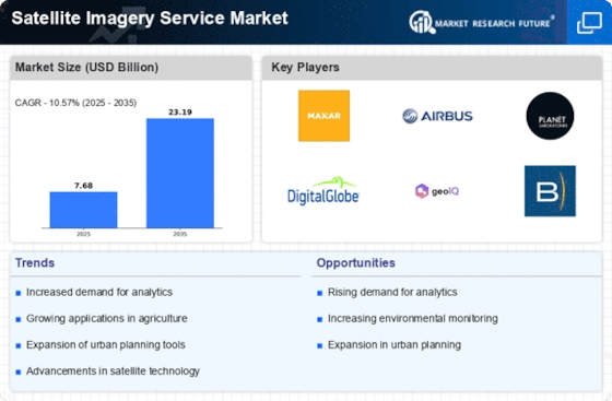
As per MRFR analysis, the Satellite Imagery Service Market Size was estimated at 5.68 (USD Billion) in 2022.The Satellite Imagery Service Market Industry is expected to grow from 6.28 (USD Billion) in 2023 to 15.5 (USD Billion) by 2032. The Satellite Imagery Service Market CAGR (growth rate) is expected to be around 10.57% during the forecast period (2024 - 2032).


Key Satellite Imagery Service Market Trends Highlighted


In terms of the Satellite Imagery Service Market, there are various key factors that play a huge role in its development, foremost of which is the ever-growing need for spatial data from various industries, including agriculture, urban planning, and environmental protection. The growing frequency and severity of natural disasters, along with a rising interest in climate change issues, have led many companies to look for dependable satellite imagery services for effective risk evaluation and management. Further, the improvement of satellite services, including owing to improved resolution and real time transmission, have also been contributing factors to the growth of the market. There is even a growing understanding among the end users of the value that satellite imagery adds when it comes to improving the quality of decisions and operational performance.Numerous opportunities remain to be explored within this market. The integration of artificial intelligence and machine learning with satellite imagery presents new avenues for innovative applications, such as predictive analytics and automated classification. Developing regions are also showing a growing interest in adopting satellite services, creating a demand for tailored solutions that cater to local needs. Moreover, partnerships between private companies and government bodies can lead to enhanced service offerings, facilitating better resource management and urban development. Recent trends in the market reflect a shift toward more comprehensive service models, with providers offering subscription-based plans that give users continuous access to updated imagery.The proliferation of drone technology has also altered the landscape, enabling hybrid solutions that combine satellite and aerial imagery for improved data accuracy. As sustainability becomes a focal point for industries worldwide, satellite imagery is increasingly utilized for monitoring environmental changes, resource utilization, and conservation efforts. This reflects a broader trend where organizations harness analytical tools derived from satellite data to pursue sustainable practices and ensure compliance with regulations while addressing challenges in real-time.


Fig 1: Satellite Imagery Service Market Overview


Satellite Imagery Service Market Overview1


Source: Primary Research, Secondary Research, MRFR Database and Analyst Review


Satellite Imagery Service Market Drivers


Increased Demand for Geospatial Data


The Satellite Imagery Service Market Industry is witnessing a surge in demand for geospatial data across various sectors. This demand stems from the rising need for accurate mapping and monitoring solutions in applications such as urban planning, agriculture, forestry, and environmental management. As businesses and governments alike seek to optimize resource allocation and enhance decision-making capability, the reliance on high-resolution satellite imagery is becoming indispensable.The advancements in satellite technology have significantly improved the quality and accessibility of geospatial data, leading to an increase in its adoption. With industries aiming to leverage these insights for competitive advantage, the Satellite Imagery Service Market is poised for sustained growth. The integration of satellite imagery with emerging technologies like artificial intelligence and machine learning is further amplifying the value of geospatial data, allowing stakeholders to uncover patterns and make predictive analyses.Consequently, the importance of satellite-based observations in developing practical, evidence-backed strategies continues to grow.


Technological Advancements in Satellite Imagery


The Satellite Imagery Service Market Industry is being driven forward by rapid technological advancements in satellite imagery. Innovations like high-resolution imaging, real-time data processing, and improved analytic tools are transforming how data is captured and utilized. Enhanced sensor capabilities are helping capture finer details, making imagery more useful for various applications, from defense and security to urban planning and environmental monitoring.These advancements enable firms to offer services that meet the increasingly specialized needs of their clients, thus expanding the market base.


Growing Applications Across Various Industries


The versatility of satellite imagery is a significant driver of growth within the Satellite Imagery Service Market Industry. Industries such as agriculture, construction, energy, and transportation have started incorporating satellite images for a wide range of purposes. This diverse applicability not only broadens the user base but also increases the frequency and volume of satellite image consumption, thus driving market expansion. As these industries continue to recognize the benefits of satellite imagery in improving efficiency and effectiveness, the market's future looks promising.


Satellite Imagery Service Market Segment Insights


Satellite Imagery Service Market Application Insights


The Satellite Imagery Service Market is witnessing substantial growth, particularly within its Applications segment, with a projected value of 6.28 USD Billion in 2023 and an expected increase to 15.5 USD Billion by 2032. This expansive growth illustrates the vital role satellite imagery plays across various sectors. The market segmentation reveals distinct demand drivers, notably in Agriculture, which is valued at 1.5 USD Billion in 2023 and is expected to grow to 3.5 USD Billion by 2032. The use of satellite imagery in agriculture facilitates precision farming, allowing farmers to monitor crop health, optimize resource use, and improve yield efficiency. Following closely is Environmental Monitoring, currently valued at 1.2 USD Billion, projected to reach 3.0 USD Billion in 2032. This application is crucial for tracking climate change, deforestation, and natural resource management, demonstrating its significant impact on sustainable practices.


Urban Planning holds a market value of 1.0 USD Billion in 2023, which is estimated to rise to 2.5 USD Billion in the next decade. This segment utilizes satellite imagery to assist city planners in understanding urban growth patterns, zoning, and infrastructure development, thereby contributing to smarter cities. The Defense and Intelligence application, valued at 1.78 USD Billion in 2023 and expected to surge to 4.0 USD Billion, is vital for national security. This signifies the increasing reliance on satellite data for reconnaissance and strategic planning. Disaster Management, while currently valued at 0.8 USD Billion, is anticipated to grow to 2.5 USD Billion, highlighting its growing importance in real-time response and recovery efforts during natural calamities. The diversity in applications indicates that the Satellite Imagery Service Market is driven by both technological advancements and the need for actionable insights across critical sectors. Overall, these segments not only showcase robust growth but also reflect how satellite imagery is becoming integral to decision-making processes, thereby shaping industry standards and practices ly.


Fig 2: Satellite Imagery Service Market Insights


Satellite Imagery Service Market Insights


Source: Primary Research, Secondary Research, MRFR Database and Analyst Review


Satellite Imagery Service Market Type of Service Insights


In 2023, the Satellite Imagery Service Market is valued at 6.28 USD Billion, reflecting a growing demand for various types of services offered in this sector. The market is segmented into several types, including 1D, 2D, 3D, and Real-Time Satellite Imagery, each catering to distinct applications. The 2D Satellite Imagery is particularly significant in geospatial analysis, urban planning, and environmental monitoring, as it provides detailed surface data. Meanwhile, 3D Satellite Imagery is gaining traction due to its ability to render volumetric data, which is crucial for construction, infrastructure development, and environmental assessments.Real-Time Satellite Imagery plays a vital role in disaster management and military operations, offering critical, timely information that can influence decision-making processes. As technological advancements continue to enhance imaging capabilities, the demand for each type is expected to rise, propelling the overall market growth significantly during the forecast period.


Satellite Imagery Service Market End Use Insights


The Satellite Imagery Service Market, valued at 6.28 USD Billion in 2023, is significantly influenced by its End Use segmentation, which includes categories such as Government, Commercial, Academic, and Non-Profit. The Government sector plays a crucial role as it utilizes satellite imagery for national security, border surveillance, and disaster management, driving considerable demand in the market. Meanwhile, the Commercial segment, characterized by applications in agriculture, real estate, and environmental monitoring, represents a significant share as businesses seek to leverage satellite data for strategic decision-making.The Academic sector also contributes through research and innovation, utilizing satellite data for various scientific studies and analyses. Non-Profit organizations increasingly depend on satellite imagery for humanitarian efforts and environmental conservation projects, indicating its vital role in social and developmental initiatives. Each of these sectors not only enhances the Satellite Imagery Service Market revenue but also reflects emerging trends, growth drivers, and opportunities while facing challenges such as data privacy and high operational costs.Overall, the diverse End Use segments collectively support the expansion and evolution of the Satellite Imagery Service Market industry, shaping its overall dynamics and market growth.


Satellite Imagery Service Market Technology Insights


The Satellite Imagery Service Market is poised for significant progress within the Technology segment, expected to reach a valuation of 6.28 billion USD in 2023 and grow to 15.5 billion USD by 2032. The market growth is advanced by increasing demand for high-resolution imagery across various industries, which has led to an expanding variety of imaging technologies. Optical Imagery plays a crucial role as it provides detailed landscape information, essential for applications in agriculture, forestry, and urban planning. Synthetic Aperture Radar (SAR) is gaining momentum due to its ability to penetrate cloud cover and provide vital data in all weather conditions, making it ideal for monitoring changes over time.Multispectral Imagery offers significant advantages for environmental monitoring, as it captures data across various bands of light, enhancing the analysis of vegetation and water resources. Hyperspectral Imagery, with its high variability of spectral information, serves to improve the identification of chemical compounds, making it a powerful tool for mineral exploration and disaster management. Together, these technologies create a diverse landscape within the Satellite Imagery Service Market industry, encouraging enterprises to leverage market data and statistics for informed decision-making.


Satellite Imagery Service Market Regional Insights


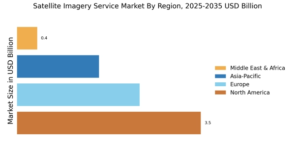
The Regional segment of the Satellite Imagery Service Market is witnessing significant growth, with a total market value of 6.28 USD Billion, expected to reach 15.5 USD Billion by 2032. North America holds a substantial majority, valued at 2.5 USD Billion in 2023 and projected to grow to 5.5 USD Billion by 2032, reflecting its dominant position driven by advanced technology adoption. Europe follows with a valuation of 1.5 USD Billion in 2023, expected to reach 3.5 USD Billion, as governments and organizations increasingly leverage satellite data for urban planning and environmental monitoring.The APAC region is also noteworthy, valued at 1.5 USD Billion in 2023 and anticipated to grow to 4.0 USD Billion, fueled by increasing demand in agricultural applications. South America and MEA are comparatively smaller segments, valued at 0.5 USD Billion and 0.3 USD Billion in 2023, respectively, but are gradually gaining importance as technology and infrastructure improve, exhibiting potential for growth. The Satellite Imagery Service Market data indicates an upward trend across these regions, influenced by the growing applications in disaster management and resource monitoring.


Fig 3: Satellite Imagery Service Market Regional Insights


Satellite Imagery Service Market Regional Insights


Source: Primary Research, Secondary Research, MRFR Database and Analyst Review


Satellite Imagery Service Market Key Players and Competitive Insights


The Satellite Imagery Service Market has been characterized by a rapidly evolving landscape driven by technological advancements and the increasing demand for accurate and timely data across various sectors, such as agriculture, urban planning, environmental monitoring, and defense. Companies offering satellite imagery services are continuously innovating their offerings to maintain a competitive edge while meeting diverse customer needs. The market is large and dynamic, with a mixture of established players and emerging startups competing based on various factors, including image resolution, frequency of data acquisition, pricing strategies, and additional analytical services. These companies are also leveraging partnerships with governmental agencies and other stakeholders to enhance their capabilities and reach in different geographies, resulting in a comprehensive value proposition that caters to a wide array of applications and industries.EOS Data Analytics has emerged as a significant player within the Satellite Imagery Service Market, recognized for its strengths in providing high-quality satellite imagery and big data analytics. The company's integrated approach combines satellite data, analytical tools, and machine learning, positioning it as a go-to choice for organizations looking to derive actionable insights from satellite imagery. EOS Data Analytics has developed advanced platforms that support their clients in making data-driven decisions across sectors like agriculture, forestry, and mining. The company's commitment to delivering high-resolution imagery and its ability to implement automated processes for data interpretation enhance its market presence and competitiveness. Furthermore, EOS Data Analytics emphasizes customer support and customization, allowing clients to tailor the services to fit specific operational needs, further solidifying its reputation in the market.Terra Bella, known for its innovative approach in the Satellite Imagery Service Market, offers a suite of satellite imagery products that are tailored to meet various analytical needs. The company focuses on providing high-frequency imagery that ensures timely data capture and supports real-time monitoring for industries such as agriculture, energy, and urban development. Leveraging its proprietary satellite technology, Terra Bella delivers unparalleled image resolution and quality, which are essential for precise analysis and decision-making. Additionally, the company's ability to integrate artificial intelligence with satellite data positions it to offer unique insights that are beneficial for strategic planning and operational efficiency. Terra Bella’s ongoing commitment to expanding its satellite constellation reflects its ambition to enhance its service offerings and maintain a competitive edge in the rapidly growing satellite imagery space.


Key Companies in the Satellite Imagery Service Market Include


  • EOS Data Analytics


  • Terra Bella


  • Satellite Imaging Corporation


  • Planet Labs


  • L3Harris Technologies


  • GeoIQ


  • BlackSky


  • Kut becomes free


  • Maxar Technologies


  • Spire


  • PlanetScope


  • Ursa Space Systems


  • DigitalGlobe


  • Ordnance Survey


  • Airbus Defence and Space


Satellite Imagery Service Market Industry Developments


The Satellite Imagery Service Market has seen significant developments recently, particularly with companies like Planet Labs and Maxar Technologies enhancing their capabilities through advanced satellite technology. EOS Data Analytics has also gained attention for integrating AI with satellite data to provide more insightful analytics. In terms of mergers and acquisitions, L3Harris Technologies has expanded its portfolio by acquiring smaller entities to strengthen its position in the satellite imaging sector. Additionally, BlackSky recently announced partnerships aimed at leveraging its satellite constellation for real-time data solutions, which may reshape market dynamics. The valuation across the market is experiencing growth, driven by increasing demand for remote sensing and geospatial analytics in various sectors, including agriculture and environmental monitoring. Companies like Ursa Space Systems and DigitalGlobe are continuously innovating to stay competitive, enhancing their services to cater to government and commercial sectors. As these developments unfold, they are contributing to a more robust and dynamic satellite imagery market, reflecting technological advancements and evolving consumer needs.


Satellite Imagery Service Market Segmentation Insights


Satellite Imagery Service Market Application Outlook


  • Agriculture

  • Environmental Monitoring

  • Urban Planning

  • Defense and Intelligence

  • Disaster Management


Satellite Imagery Service Market Type of Service Outlook


  • 1D Satellite Imagery

  • 2D Satellite Imagery

  • 3D Satellite Imagery

  • Real-Time Satellite Imagery


Satellite Imagery Service Market End Use Outlook


  • Government

  • Commercial

  • Academic

  • Non-Profit


Satellite Imagery Service Market Technology Outlook


  • Optical Imagery

  • Synthetic Aperture Radar

  • Multispectral Imagery

  • Hyperspectral Imagery


Satellite Imagery Service Market Regional Outlook


  • North America

  • Europe

  • South America

  • Asia Pacific

  • Middle East and Africa

Report Attribute/Metric Details
Market Size 2022 5.68 (USD Billion)
Market Size 2023 6.28 (USD Billion)
Market Size 2032 15.5 (USD Billion)
Compound Annual Growth Rate (CAGR) 10.57% (2024 - 2032)
Report Coverage Revenue Forecast, Competitive Landscape, Growth Factors, and Trends
Base Year 2023
Market Forecast Period 2024 - 2032
Historical Data 2019 - 2023
Market Forecast Units USD Billion
Key Companies Profiled EOS Data Analytics, Terra Bella, Satellite Imaging Corporation, Planet Labs, L3Harris Technologies, GeoIQ, BlackSky, Kut becomes free, Maxar Technologies, Spire , PlanetScope, Ursa Space Systems, DigitalGlobe, Ordnance Survey, Airbus Defence and Space
Segments Covered Application, Type of Service, End Use, Technology, Regional
Key Market Opportunities Increased demand for agricultural analytics, Growth in defense and security applications, Expansion of smart city initiatives, Rise of environmental monitoring needs, Advancements in satellite technology and data analytics
Key Market Dynamics Increasing demand for geospatial data, Advancements in satellite technology, Growing applications in agriculture, Rising need for environmental monitoring, Expansion of defense and security sectors
Countries Covered North America, Europe, APAC, South America, MEA


Frequently Asked Questions (FAQ) :

The Satellite Imagery Service Market is expected to be valued at 15.5 USD Billion by 2032.

The expected CAGR for the Satellite Imagery Service Market is 10.57% from 2024 to 2032.

North America is projected to dominate the market with an expected value of 5.5 USD Billion by 2032.

The Agriculture application segment of the Satellite Imagery Service Market is expected to be valued at 3.5 USD Billion in 2032.

Major players include EOS Data Analytics, Planet Labs, Maxar Technologies, and Airbus Defence and Space, among others.

The Defense and Intelligence application segment is anticipated to reach a market value of 4.0 USD Billion by 2032.

The Environmental Monitoring application segment is expected to grow to a market value of 3.0 USD Billion by 2032.

The European region is projected to have a market value of 3.5 USD Billion by 2032.

The Disaster Management application segment is expected to grow to 2.5 USD Billion by 2032.

The APAC region is projected to reach a market value of 4.0 USD Billion by 2032.

Leading companies partner with us for data-driven Insights
client_1 client_2 client_3 client_4 client_5 client_6 client_7 client_8 client_9 client_10
Kindly complete the form below to receive a free sample of this Report
Please fill in Business Email for Quick Response

We do not share your information with anyone. However, we may send you emails based on your report interest from time to time. You may contact us at any time to opt-out.

Purchase Option
Single User $ 4,950
Multiuser License $ 5,950
Enterprise User $ 7,250
Compare Licenses
Tailored for You
  • Dedicated Research on any specifics segment or region.
  • Focused Research on specific players in the market.
  • Custom Report based only on your requirements.
  • Flexibility to add or subtract any chapter in the study.
  • Historic data from 2014 and forecasts outlook till 2040.
  • Flexibility of providing data/insights in formats (PDF, PPT, Excel).
  • Provide cross segmentation in applicable scenario/markets.