• Cat-intel
  • MedIntelliX
  • Resources
  • About Us
  • Request Free Sample ×

    Kindly complete the form below to receive a free sample of this Report

    Leading companies partner with us for data-driven Insights

    clients tt-cursor
    Hero Background

    Japan Geospatial Imagery Analytics Market

    ID: MRFR/ICT/61015-HCR
    200 Pages
    Aarti Dhapte
    October 2025

    Japan Geospatial Imagery Analytics Market Research Report By Analytics type (Video-based Analytics, Imagery Analytics), By Deployment Type (Cloud, On-Premises) and By End-User Type (Government, Defense & Security, Engineering & Construction, Mining & Manufacturing, Agriculture, Insurance, Healthcare, Environment Monitoring, Energy, Utility, Natural Resources, Others) - Forecast to 2035

    Share:
    Download PDF ×

    We do not share your information with anyone. However, we may send you emails based on your report interest from time to time. You may contact us at any time to opt-out.

    Japan Geospatial Imagery Analytics Market Infographic
    Purchase Options

    Japan Geospatial Imagery Analytics Market Summary

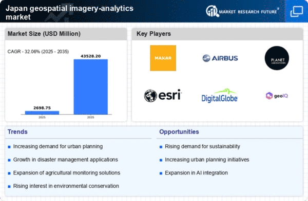
    As per MRFR analysis, the geospatial imagery-analytics market size was estimated at 2043.58 USD Million in 2024. The geospatial imagery-analytics market is projected to grow from 2698.75 USD Million in 2025 to 43528.2 USD Million by 2035, exhibiting a compound annual growth rate (CAGR) of 32.06% during the forecast period 2025 - 2035.

    Key Market Trends & Highlights

    The Japan geospatial imagery-analytics market is poised for substantial growth driven by technological advancements and increasing demand for urban planning solutions.

    • The integration of AI and Machine Learning is transforming data analysis in the geospatial imagery-analytics sector.
    • Government initiatives aimed at developing smart cities are propelling the adoption of geospatial technologies.
    • Environmental monitoring and sustainability efforts are gaining traction, particularly in urban areas.
    • Technological advancements in remote sensing and rising demand for urban planning solutions are key drivers of market growth.

    Market Size & Forecast

    2024 Market Size 2043.58 (USD Million)
    2035 Market Size 43528.2 (USD Million)

    Major Players

    Maxar Technologies (US), Airbus (FR), Planet Labs (US), Esri (US), DigitalGlobe (US), GeoIQ (US), BlackSky (US), L3Harris Technologies (US)

    Japan Geospatial Imagery Analytics Market Trends

    The geospatial imagery-analytics market is experiencing notable growth, driven by advancements in technology and increasing demand for data-driven decision-making. In Japan, the integration of artificial intelligence and machine learning into geospatial analytics is transforming how organizations utilize spatial data. This evolution allows for enhanced predictive modeling and improved operational efficiency across various sectors, including agriculture, urban planning, and disaster management. Furthermore, the government's emphasis on smart city initiatives and infrastructure development is likely to bolster the adoption of geospatial technologies, as stakeholders seek innovative solutions to address urban challenges. Moreover, the rising awareness of environmental issues and the need for sustainable practices are propelling the geospatial imagery-analytics market forward. Organizations are increasingly leveraging spatial data to monitor environmental changes, assess natural resources, and implement conservation strategies. The collaboration between public and private sectors in Japan is fostering a conducive environment for innovation, enabling the development of tailored solutions that meet specific regional needs. As the market continues to evolve, it appears poised for further expansion, with potential applications extending into various industries, thereby enhancing overall productivity and sustainability.

    Integration of AI and Machine Learning

    The incorporation of artificial intelligence and machine learning technologies into geospatial analytics is reshaping the landscape. This trend enables organizations to process vast amounts of spatial data more efficiently, leading to improved insights and decision-making capabilities.

    Government Initiatives and Smart Cities

    Japan's focus on smart city projects and infrastructure development is driving the demand for geospatial technologies. These initiatives aim to enhance urban living conditions and optimize resource management through advanced spatial analysis.

    Environmental Monitoring and Sustainability

    The increasing emphasis on environmental sustainability is pushing organizations to utilize geospatial imagery for monitoring ecological changes. This trend supports efforts in resource management and conservation, aligning with global sustainability goals.

    Japan Geospatial Imagery Analytics Market Drivers

    Expansion of Agricultural Technologies

    The agricultural sector in Japan is increasingly adopting geospatial imagery-analytics to enhance productivity and sustainability. Farmers and agribusinesses are utilizing geospatial data to optimize crop management, monitor soil health, and improve yield forecasting. The integration of precision agriculture techniques, supported by geospatial analytics, is transforming traditional farming practices. Reports indicate that the agricultural technology market is expected to grow by over 15% annually, with a significant portion of this growth attributed to geospatial technologies. As the demand for food security rises, the geospatial imagery-analytics market is likely to see increased investment and innovation, reflecting the sector's commitment to leveraging data for improved agricultural outcomes.

    Increased Focus on Disaster Management

    Japan's geographical location makes it prone to natural disasters, necessitating robust disaster management strategies. The geospatial imagery-analytics market plays a pivotal role in this context, providing critical data for risk assessment and emergency response. Advanced analytics can help in predicting disaster impacts and optimizing resource allocation during emergencies. The government has been investing heavily in technologies that enhance disaster preparedness, with estimates suggesting an allocation of approximately $300 million towards geospatial technologies in disaster management. This focus on leveraging geospatial data for safety and resilience is likely to drive growth in the geospatial imagery-analytics market, as stakeholders seek to improve their capabilities in managing disaster risks.

    Rising Demand for Urban Planning Solutions

    Urbanization in Japan is accelerating, leading to an increased demand for effective urban planning solutions. The geospatial imagery-analytics market is positioned to benefit from this trend, as city planners and local governments seek to utilize geospatial data for infrastructure development and resource management. The integration of geospatial analytics into urban planning processes allows for better visualization of land use, transportation networks, and environmental impacts. Reports indicate that the urban planning sector is expected to allocate over $500 million to geospatial technologies in the coming years. This investment reflects a growing recognition of the value of data-driven decision-making in managing urban growth, thereby enhancing the prospects for the geospatial imagery-analytics market.

    Technological Advancements in Remote Sensing

    The geospatial imagery-analytics market in Japan is experiencing a surge due to rapid technological advancements in remote sensing technologies. Innovations in satellite imaging, drones, and sensor technologies have enhanced the quality and accuracy of geospatial data. For instance, the resolution of satellite imagery has improved significantly, allowing for more detailed analysis. This is particularly relevant in urban planning and disaster management, where precise data is crucial. The market is projected to grow at a CAGR of approximately 12% over the next five years, driven by these advancements. As organizations increasingly rely on high-resolution imagery for decision-making, the demand for sophisticated analytics tools is likely to rise, further propelling the geospatial imagery-analytics market in Japan.

    Growing Interest in Environmental Conservation

    Environmental conservation efforts in Japan are gaining momentum, leading to an increased reliance on geospatial imagery-analytics. The market is witnessing a rise in demand for tools that can monitor environmental changes, assess biodiversity, and manage natural resources. Organizations are utilizing geospatial data to track deforestation, water quality, and land use changes, which are critical for sustainable development. The government has set ambitious targets for reducing carbon emissions, and geospatial analytics is seen as a vital component in achieving these goals. With an estimated investment of $200 million in environmental monitoring technologies, the geospatial imagery-analytics market is likely to expand as stakeholders prioritize sustainability and conservation initiatives.

    Market Segment Insights

    Japan Geospatial Imagery Analytics Market Segment Insights

    Japan Geospatial Imagery Analytics Market Segment Insights

    Geospatial Imagery Analytics Market Analytics

    Geospatial Imagery Analytics Market Analytics Type Insights

    The Japan Geospatial Imagery Analytics Market is showcasing significant growth driven by advancements in technology and the increasing need for efficient data analysis in various sectors. Among the analytics types, Video-based Analytics and Imagery Analytics hold major relevance, often dominating the market due to their practicality and effectiveness. Video-based Analytics provides real-time surveillance and monitoring capabilities, making it particularly valuable in sectors such as security, transportation, and urban planning.

    As Japan focuses on enhancing smart city initiatives and improving public safety measures, the demand for video analytics is expected to surge, leveraging machine learning and artificial intelligence to extract actionable insights from video feeds.On the other hand, Imagery Analytics utilizes satellite images and aerial photography, playing a critical role in environmental monitoring, agriculture, and urban development. 

    The ability to analyze large datasets derived from imagery provides decision-makers with the tools necessary to understand changes in land use, assess natural disaster impacts, and optimize resource allocation. Both analytics types are witnessing innovation in analytical techniques and processing capabilities, catering to a plethora of applications across industries.

    The synergy between these analytics forms is creating vast opportunities for businesses in Japan to improve operational efficiencies, while also addressing pressing social and economic challenges.As the government of Japan continues to invest in technological infrastructure and data accessibility, the relevance of Video-based Analytics and Imagery Analytics within the broader landscape of the Japan Geospatial Imagery Analytics Market will further solidify, making them integral to future developments.

    Source: Primary Research, Secondary Research, Market Research Future Database and Analyst Review

    Geospatial Imagery Analytics Market Deployment Type Insights

    Geospatial Imagery Analytics Market Deployment Type Insights

    The Japan Geospatial Imagery Analytics Market, particularly within the Deployment Type segment, showcases a dynamic landscape that is increasingly pivotal for various industries, including agriculture, urban planning, and disaster management. The market has experienced notable growth driven by advancements in cloud computing and the versatility of on-premises solutions. Cloud deployment is becoming increasingly favored due to its scalability, ease of access, and cost-effectiveness, enabling organizations to leverage extensive geospatial data without significant upfront investments in infrastructure.This approach allows for real-time data processing and analysis, benefiting sectors that require swift decision-making. 

    On the other hand, on-premises deployment remains significant for organizations with stringent data security and compliance requirements. It offers bespoke solutions tailored to specific operational needs, especially for governmental and defense sectors in Japan, which prioritize data sovereignty. As the country strives for technological innovation, the balance between these deployment methods will be crucial in maximizing the potential of geospatial imagery analytics to address various socio-economic challenges.Overall, the deployment landscape in the Japan Geospatial Imagery Analytics Market is positioned for substantial evolution, adapting to emerging technologies and user demands.

    Geospatial Imagery Analytics Market End-User Type Insights

    Geospatial Imagery Analytics Market End-User Type Insights

    The Japan Geospatial Imagery Analytics Market is characterized by a diverse array of End-User Types that drive its robust growth. Among these, the Government sector plays a crucial role as it utilizes geospatial imagery for urban planning, crisis management, and infrastructure development, thereby enhancing public services and safety. The Defense and Security sector heavily relies on advanced geospatial analytics to ensure national security through surveillance and threat assessment. Engineering and Construction leverage this technology for site analysis and project monitoring, which maximizes efficiency and reduces costs.

    In Agriculture, geospatial imagery is pivotal for precision farming, helping farmers optimize their land use and improve yield.

    The Mining and Manufacturing sectors utilize spatial data for resource exploration and logistical management. Healthcare applications focus on public health improvements through environmental monitoring and location-based services, while Insurance companies use imagery analytics to assess risks and streamline claims processes. Environment Monitoring is vital in Japan, particularly in tracking natural disasters and ecological changes. Moreover, the Energy and Utility sectors benefit from data to optimize resource usage and enhance sustainability efforts. Overall, each of these segments contributes significantly to the Japan Geospatial Imagery Analytics Market, reflecting its importance in addressing contemporary challenges and opportunities across various industries.

    Get more detailed insights about Japan Geospatial Imagery Analytics Market

    Key Players and Competitive Insights

    The geospatial imagery-analytics market in Japan is characterized by a dynamic competitive landscape, driven by technological advancements and increasing demand for data-driven decision-making across various sectors. Key players such as Maxar Technologies (US), Airbus (FR), and Planet Labs (US) are strategically positioned to leverage their innovative capabilities and extensive satellite networks. Maxar Technologies (US) focuses on enhancing its Earth observation capabilities through advanced imaging technologies, while Airbus (FR) emphasizes partnerships with local entities to expand its market reach. Planet Labs (US) is notable for its agile satellite deployment strategy, which allows for rapid data acquisition and analysis, thereby shaping a competitive environment that prioritizes speed and accuracy in data delivery.

    The market structure appears moderately fragmented, with several players vying for market share through localized strategies and supply chain optimization. Companies are increasingly localizing their operations to better serve the Japanese market, which may enhance responsiveness to customer needs and regulatory requirements. This localized approach, combined with strategic partnerships, enables these firms to navigate the complexities of the market while maintaining competitive pricing and service offerings.

    In October 2025, Maxar Technologies (US) announced a collaboration with a leading Japanese telecommunications company to enhance satellite data integration into urban planning initiatives. This partnership is strategically significant as it aligns with Japan's focus on smart city development, potentially positioning Maxar as a key player in the urban analytics space. The integration of satellite data into urban planning could lead to more efficient resource allocation and improved infrastructure development.

    In September 2025, Airbus (FR) launched a new satellite designed specifically for high-resolution imaging, aimed at supporting disaster management efforts in Japan. This move underscores Airbus's commitment to addressing regional challenges, particularly in a country prone to natural disasters. By providing timely and accurate imagery, Airbus enhances its value proposition to government agencies and emergency responders, thereby solidifying its market position.

    In August 2025, Planet Labs (US) expanded its operations in Japan by establishing a data center in Tokyo, aimed at improving data processing capabilities for local clients. This strategic expansion is likely to enhance Planet's service delivery and responsiveness, allowing for quicker turnaround times on data requests. The establishment of a local data center may also foster stronger relationships with Japanese businesses and government entities, further entrenching Planet's presence in the market.

    As of November 2025, the competitive trends in the geospatial imagery-analytics market are increasingly defined by digitalization, sustainability, and the integration of artificial intelligence (AI). Strategic alliances are becoming more prevalent, as companies recognize the need to collaborate to enhance technological capabilities and market reach. The shift from price-based competition to a focus on innovation and technology is evident, with firms investing in advanced analytics and reliable supply chains to differentiate themselves. Looking ahead, competitive differentiation is likely to evolve further, emphasizing the importance of technological advancements and sustainable practices in shaping the future landscape of the market.

    Key Companies in the Japan Geospatial Imagery Analytics Market market include

    Industry Developments

    The Japan Geospatial Imagery Analytics Market has seen significant developments recently. In October 2023, Mitsubishi Electric announced advancements in satellite technology aimed at enhancing high-resolution imagery for various urban applications. In the same month, JAXA (Japan Aerospace Exploration Agency) collaborated with various entities to launch new Earth observation satellites intended to improve data accessibility for environmental monitoring. Moreover, the partnership between Planet Labs and the Remote Sensing Technology Center of Japan, formalized in September 2023, aims to leverage advanced analytics for more accurate agriculture monitoring and disaster management. 

    Regarding mergers and acquisitions, Maxar Technologies completed a significant acquisition of a data analytics firm in August 2023, aiming to strengthen its position in the Asia-Pacific market, including Japan. The market is poised for growth, with estimates indicating an increased valuation driven by heightened governmental focus on environmental sustainability, urban planning, and disaster response. Companies like Google and IBM continue to expand their analytics capabilities for geospatial data, fostering innovation across various sectors in Japan. As the market evolves, ongoing partnerships and technological advancements are expected to facilitate progressive enhancements in geospatial analytics applications.

    Future Outlook

    Japan Geospatial Imagery Analytics Market Future Outlook

    The geospatial imagery-analytics market is projected to grow at a 32.06% CAGR from 2024 to 2035, driven by advancements in satellite technology and increasing demand for data-driven decision-making.

    New opportunities lie in:

    • Development of AI-driven analytics platforms for real-time data processing.
    • Expansion of geospatial data services for urban planning and infrastructure development.
    • Integration of geospatial analytics in supply chain optimization solutions.

    By 2035, the market is expected to achieve substantial growth, driven by innovative applications and technological advancements.

    Market Segmentation

    Japan Geospatial Imagery Analytics Market End-User Type Outlook

    • Government
    • Defense & Security
    • Engineering & Construction
    • Mining & Manufacturing
    • Agriculture
    • Insurance
    • Healthcare
    • Environment Monitoring
    • Energy, Utility, and Natural Resources
    • Others

    Japan Geospatial Imagery Analytics Market Analytics Type Outlook

    • Video-Based Analytics
    • Imagery Analytics

    Japan Geospatial Imagery Analytics Market Deployment Type Outlook

    • Cloud
    • On-Premises

    Report Scope

    MARKET SIZE 20242043.58(USD Million)
    MARKET SIZE 20252698.75(USD Million)
    MARKET SIZE 203543528.2(USD Million)
    COMPOUND ANNUAL GROWTH RATE (CAGR)32.06% (2024 - 2035)
    REPORT COVERAGERevenue Forecast, Competitive Landscape, Growth Factors, and Trends
    BASE YEAR2024
    Market Forecast Period2025 - 2035
    Historical Data2019 - 2024
    Market Forecast UnitsUSD Million
    Key Companies Profiled["Maxar Technologies (US)", "Airbus (FR)", "Planet Labs (US)", "Esri (US)", "DigitalGlobe (US)", "GeoIQ (US)", "BlackSky (US)", "L3Harris Technologies (US)"]
    Segments CoveredAnalytics Type, Deployment Type, End-User Type
    Key Market OpportunitiesIntegration of artificial intelligence in geospatial imagery-analytics enhances data processing and decision-making capabilities.
    Key Market DynamicsRising demand for advanced geospatial analytics driven by urbanization and environmental monitoring initiatives in Japan.
    Countries CoveredJapan

    Leave a Comment

    FAQs

    What is the projected market size of the Japan Geospatial Imagery Analytics Market in 2024?

    The Japan Geospatial Imagery Analytics Market is projected to be valued at 1.5 USD Billion in 2024.

    What is the expected valuation of the market by 2035?

    By 2035, the Japan Geospatial Imagery Analytics Market is expected to reach a valuation of 12.0 USD Billion.

    What is the expected CAGR for the market from 2025 to 2035?

    The market is expected to grow at a CAGR of 20.809% from 2025 to 2035.

    Which segment is expected to dominate the market value in 2024?

    In 2024, the Imagery Analytics segment is valued at 0.9 USD Billion, while Video-based Analytics is valued at 0.6 USD Billion.

    What will be the market value of Video-based Analytics by 2035?

    By 2035, the Video-based Analytics segment is expected to reach 4.8 USD Billion.

    What is the expected market value of Imagery Analytics by 2035?

    The Imagery Analytics segment is projected to be valued at 7.2 USD Billion by 2035.

    Who are the key players in the Japan Geospatial Imagery Analytics Market?

    Key players in the market include Mitsubishi Electric, DigitalGlobe, Google, and others.

    What are the main applications driving growth in this market?

    Applications such as urban planning, disaster management, and environmental monitoring are driving market growth.

    What are some emerging trends in the Japan Geospatial Imagery Analytics Market?

    Emerging trends include the increasing use of artificial intelligence and machine learning in analytics.

    How is the current global scenario impacting the Japan Geospatial Imagery Analytics Market?

    The current global scenario affects demand fluctuations and may influence investment in geospatial technologies.

    Download Free Sample

    Kindly complete the form below to receive a free sample of this Report

    Case Study
    Chemicals and Materials

    Compare Licence

    ×
    Features License Type
    Single User Multiuser License Enterprise User
    Price $4,950 $5,950 $7,250
    Maximum User Access Limit 1 User Upto 10 Users Unrestricted Access Throughout the Organization
    Free Customization
    Direct Access to Analyst
    Deliverable Format
    Platform Access
    Discount on Next Purchase 10% 15% 15%
    Printable Versions