• Cat-intel
  • MedIntelliX
  • Resources
  • About Us
  • Request Free Sample ×

    Kindly complete the form below to receive a free sample of this Report

    Leading companies partner with us for data-driven Insights

    clients tt-cursor

    Agricultural Mapping and Imaging Market

    ID: MRFR/ICT/32991-HCR
    100 Pages
    Aarti Dhapte
    September 2025

    Agricultural Mapping and Imaging Market Research Report: By Technology (Satellite Imaging, Drone Imaging, Ground-Based Sensors, GIS Technology), By Application (Crop Monitoring, Soil Analysis, Yield Prediction, Pest and Disease Management), By End Use (Farmers, Agricultural Consultants, Government Agencies, Research Institutions), By Component (Hardware, Software, Services) and By Regional (North America, Europe, South America, Asia Pacific, Middle East and Africa) - Forecast to 2034.

    Share:
    Download PDF ×

    We do not share your information with anyone. However, we may send you emails based on your report interest from time to time. You may contact us at any time to opt-out.

    Agricultural Mapping and Imaging Market Research Report - Global Forecast to 2034 Infographic
    Purchase Options
    $ 4,950.0
    $ 5,950.0
    $ 7,250.0

    Agricultural Mapping and Imaging Market Summary

    The Global Agricultural Mapping and Imaging Market is projected to grow significantly from 4.62 USD Billion in 2024 to 11.7 USD Billion by 2035.

    Key Market Trends & Highlights

    Agricultural Mapping and Imaging Key Trends and Highlights

    • The market is expected to experience a compound annual growth rate (CAGR) of 8.81% from 2025 to 2035.
    • By 2035, the market valuation is anticipated to reach 11.7 USD Billion, indicating robust growth potential.
    • In 2024, the market is valued at 4.62 USD Billion, reflecting the increasing demand for advanced agricultural technologies.
    • Growing adoption of precision agriculture due to the need for enhanced crop yield is a major market driver.

    Market Size & Forecast

    2024 Market Size 4.62 (USD Billion)
    2035 Market Size 11.7 (USD Billion)
    CAGR (2025-2035) 8.81%

    Major Players

    CropIn Technology, John Deere, Esri, Satellite Mapping Technologies, DigitalGlobe, FarmLogs, Planet Labs, MDA, PrecisionHawk, AgEagle Aerial Systems, Sentera, Trimble, GeoIQ, SkyWatch, Griffon Corporation

    Agricultural Mapping and Imaging Market Trends

    Opportunities in the agricultural mapping and imaging domain are vast and varied. The integration of artificial intelligence and machine learning in data analysis can streamline processes and provide actionable insights. This creates a compelling avenue for companies to develop innovative solutions that cater to the needs of smaller farms and emerging markets. Additionally, increasing government initiatives focused on enhancing food security through technology utilization presents a ripe opportunity for investment and growth. The focus on enhancing crop productivity while minimizing environmental impact complements the innovation push within this sector.

    Recent trends indicate a growing inclination towards interoperability among different mapping and imaging systems. This enables comprehensive data sharing and enhances collaboration among stakeholders in the agricultural value chain. Moreover, the integration of mobile applications for real-time data access has gained traction, improving farmers' ability to make informed decisions on the go. As sustainability and efficiency become paramount goals in agriculture, the emphasis on smart farming technologies continues to evolve, driving passion and commitment toward innovation in the agricultural mapping and imaging field.

    The ongoing digital transformation in agriculture signals a promising future for the market, cultivating networks that connect farmers, suppliers, and researchers.

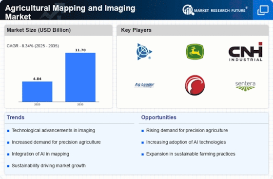
    Fig 1: Agricultural Mapping and Imaging Market Overview

    The integration of advanced imaging technologies in agriculture is poised to enhance precision farming practices, thereby optimizing resource management and increasing crop yields.

    United States Department of Agriculture (USDA)

    Agricultural Mapping and Imaging Market Drivers

    Market Growth Projections

    Government Initiatives and Support

    Government initiatives play a crucial role in the expansion of the Global Agricultural Mapping and Imaging Market Industry. Various countries are implementing policies that promote the adoption of advanced agricultural technologies, including mapping and imaging solutions. For example, subsidies and grants for farmers to invest in precision agriculture tools are becoming more common. Additionally, governments are investing in research and development to enhance the capabilities of agricultural mapping technologies. Such support not only encourages innovation but also fosters collaboration between public and private sectors, potentially accelerating market growth and adoption rates.

    Technological Advancements in Imaging

    The Global Agricultural Mapping and Imaging Market Industry is experiencing rapid growth due to advancements in imaging technologies such as satellite imagery, drones, and remote sensing. These innovations enable farmers and agricultural businesses to obtain precise data on crop health, soil conditions, and weather patterns. For instance, the integration of multispectral and hyperspectral imaging allows for detailed analysis of plant health, which can lead to improved yield predictions. As these technologies become more accessible, the market is projected to reach 4.62 USD Billion in 2024, reflecting a growing reliance on data-driven decision-making in agriculture.

    Rising Global Population and Food Demand

    The Global Agricultural Mapping and Imaging Market Industry is significantly influenced by the increasing global population and the corresponding rise in food demand. As the world population is projected to reach approximately 9.7 billion by 2050, the pressure on agricultural systems to produce more food becomes more pronounced. Mapping and imaging technologies offer solutions to enhance agricultural productivity by providing critical insights into crop management and resource allocation. This necessity for increased food production is likely to drive market growth, with projections indicating a compound annual growth rate of 8.81% from 2025 to 2035.

    Increasing Demand for Precision Agriculture

    The Global Agricultural Mapping and Imaging Market Industry is driven by the rising demand for precision agriculture practices. Farmers are increasingly adopting mapping and imaging technologies to optimize resource use, enhance crop productivity, and reduce environmental impact. This trend is supported by the need for sustainable farming practices that align with global food security goals. By utilizing advanced imaging techniques, farmers can monitor crop conditions in real-time, leading to more efficient use of fertilizers and water. This shift towards precision agriculture is expected to contribute to a market growth trajectory that could see it reach 11.7 USD Billion by 2035.

    Environmental Sustainability and Climate Change Adaptation

    The Global Agricultural Mapping and Imaging Market Industry is also shaped by the growing emphasis on environmental sustainability and the need for climate change adaptation. As agricultural practices face challenges from changing climate conditions, mapping and imaging technologies provide vital data to help farmers adapt their strategies. For instance, these technologies can assist in identifying areas at risk of drought or flooding, enabling proactive measures to mitigate risks. The increasing awareness of sustainable farming practices is likely to propel the market forward, as stakeholders seek to balance productivity with environmental stewardship.

    Market Segment Insights

    Agricultural Mapping and Imaging Market Segment Insights

    Agricultural Mapping and Imaging Market Segment Insights

    Agricultural Mapping and Imaging Market Technology Insights

    Agricultural Mapping and Imaging Market Technology Insights

    The Agricultural Mapping and Imaging Market is expected to showcase significant growth fueled by advancements in technology. In 2023, the market is valued at 4.13 USD Billion and reflects a growing trend towards precision agriculture. Among the various technologies, Satellite Imaging holds a majority share, valued at 1.5 USD Billion in 2023, and is projected to reach 3.1 USD Billion by 2032. This technology is significant as it allows for extensive coverage and timely assessment of large agricultural areas, enabling better decision-making for farmers.

    Drone Imaging represents another critical component of the market, valued at 1.0 USD Billion in 2023 and is anticipated to increase to 2.1 USD Billion by 2032. The utility of drones in capturing high-resolution images enables detailed analysis of crop health, irrigation patterns, and field variability, making it an essential tool for modern farming. Ground-based sensors, with a valuation of 0.8 USD Billion in 2023 and a projection of 1.7 USD Billion by 2032, play a vital role in providing real-time data on soil conditions, moisture levels, and crop status, thereby supporting timely interventions.

    GIS Technology, valued at 0.83 USD Billion in 2023 and expected to rise to 1.6 USD Billion by 2032, enables farmers to analyze spatial data and make informed decisions regarding land use, resource allocation, and environmental management. Overall, the Agricultural Mapping and Imaging Market segmentation shows a diverse landscape of technologies, where Satellite Imaging remains the most dominant, followed closely by Drone Imaging, highlighting the pivotal role these technologies play in enhancing agricultural productivity and sustainability.

    The growth of this market is underpinned by the increasing demand for data-driven farming, which is increasingly being recognized as a critical strategy for addressing food security and optimizing resource use. As the market expands, opportunities for innovation and collaboration within these technology segments are expected to drive further advancements in precision agriculture.

    Fig 2: Agricultural Mapping and Imaging Market Insights

    Fig 2: Agricultural Mapping and Imaging Market Insights

    Source: Primary Research, Secondary Research, Market Research Future Database and Analyst Review

    Agricultural Mapping and Imaging Market Application Insights

    Agricultural Mapping and Imaging Market Application Insights

    The Agricultural Mapping and Imaging Market is poised for significant growth, particularly within its Application segment. With a total market valuation expected to reach 4.13 billion USD in 2023, the demand for precision agriculture tools is on the rise, driven by the need for efficient farming practices. Crop Monitoring is essential for real-time insights into plant health, impacting yield optimization, while Soil Analysis informs farmers about nutrient management, ensuring sustainable practices. Yield Prediction stands as a crucial aspect, allowing farmers to forecast outputs and strategize accordingly, ultimately enhancing productivity.

    Pest and Disease Management is also a prominent focus, as leveraging mapping and imaging technologies can lead to early detection and control measures, significantly reducing crop losses. This growing interest in specific applications demonstrates the importance of technological advancements in the agricultural sector, positioning the Agricultural Mapping and Imaging Market as a key player in improving food security and resource management. The overall segmentation is not only essential for understanding market dynamics but also for aligning technological developments with critical agricultural needs.

    Agricultural Mapping and Imaging Market End-Use Insights

    Agricultural Mapping and Imaging Market End-Use Insights

    The Agricultural Mapping and Imaging Market encompasses a diverse range of end-use applications that cater to various sectors within agriculture. Key players in this market include Farmers, Agricultural Consultants, Government Agencies, and Research Institutions, each playing a significant role in driving innovation and effectiveness in agricultural practices. As of 2023, the market was valued at approximately 4.13 USD Billion, showcasing substantial growth potential. Farmers utilize mapping and imaging technologies to enhance crop yields and optimize resource management, which is critical for meeting the increasing food demand.

    Agricultural Consultants leverage these tools to provide expert advice and solutions to their clients, making them essential in agricultural productivity. Government Agencies are increasingly adopting these technologies to implement effective agricultural policies and monitor land use, addressing food security challenges. Research Institutions utilize mapping and imaging for advanced studies in crop science and environmental impacts, leading to sustainable agricultural practices. The interplay between these end users reflects the multi-faceted applications of Agricultural Mapping and Imaging Market data, driving growth and innovation within the industry.

    Agricultural Mapping and Imaging Market Component Insights

    Agricultural Mapping and Imaging Market Component Insights

    The Agricultural Mapping and Imaging Market, valued at 4.13 billion USD in 2023, encompasses various components that drive its growth and functionality. The market segmentation includes essential elements like Hardware, Software, and Services. Hardware plays a crucial role, providing the necessary tools for data collection and analysis in agricultural practices. Meanwhile, Software is significant as it enhances data interpretation, offering farmers vital insights for better decision-making. Services, including consulting and technical support, are essential to ensure the effective deployment and utilization of mapping and imaging technologies.

    With the market expected to expand significantly, these components collectively contribute to the overall efficiency and productivity of the agricultural sector. As the industry evolves, advancements in technology and increased adoption of precision farming practices will further fuel the demand for agricultural mapping and imaging solutions. The expected growth trajectory highlights the potential for innovation and investment in these components, aligning with the market's shifting trends and the increasing need for sustainable agricultural practices.

    Get more detailed insights about Agricultural Mapping and Imaging Market Research Report - Global Forecast to 2034

    Regional Insights

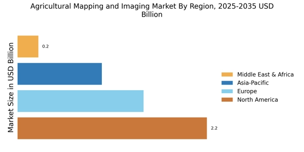
    The Agricultural Mapping and Imaging Market is witnessing robust growth across various regions, with a total market revenue reaching 4.13 USD Billion in 2023. North America holds a majority position within the market, valued at 1.5 USD Billion, and is expected to grow to 3.1 USD Billion by 2032, demonstrating its dominance primarily due to advanced agricultural practices and technology adoption. Europe follows with significant traction, valued at 1.2 USD Billion in 2023 and projected to reach 2.5 USD Billion, driven by a strong focus on precision farming and government initiatives.

    The APAC region also shows substantial potential, valued at 1.0 USD Billion in 2023, highlighting investments in agricultural technology. On the other hand, South America, with a value of 0.3 USD Billion, and MEA at 0.13 USD Billion, represent emerging markets with growth opportunities, although they currently hold smaller portions of the overall market. The variations in the Agricultural Mapping and Imaging Market data emphasize the differing agricultural needs and technological advancements across regions, creating diverse opportunities for stakeholders.

    Fig 3: Agricultural Mapping and Imaging Market Regional Insights

    Agricultural Mapping and Imaging Market Regional Insights

    Source: Primary Research, Secondary Research, Market Research Future Database and Analyst Review

    Key Players and Competitive Insights

    The Agricultural Mapping and Imaging Market is characterized by rapid technological advancements and an increasing emphasis on precision agriculture. Various stakeholders, including agricultural companies, research institutions, and government agencies, engage in a competitive landscape shaped by the demand for innovative solutions that enhance crop yield and optimize resource management. The integration of advanced imaging technologies, such as remote sensing and geographic information systems, supports the generation of detailed agricultural maps that aid in effective decision-making.

    As environmental concerns and the need for sustainable farming practices persist, market players are innovating to provide comprehensive mapping services that meet the diverse needs of the agricultural sector. 

    The competitive environment is further intensified by regular collaborations and partnerships aimed at expanding service offerings and market reach.CropIn Technology has made significant strides in the Agricultural Mapping and Imaging Market by leveraging its robust technology framework. The company is recognized for its data-driven solutions that enable farmers to monitor field conditions in real-time, thereby facilitating improved crop management. With a strong emphasis on agricultural intelligence, CropIn Technology’s capabilities include integrating satellite imagery with on-ground data to provide actionable insights.

    This fusion of data allows for greater accuracy in predicting crop performance and optimizing inputs, providing a competitive edge in precision farming. The company's commitment to innovation and sustainability has positioned it as a leader in enhancing productivity and ensuring the efficient use of resources within the agricultural landscape.

    John Deere stands out in the Agricultural Mapping and Imaging Market through its comprehensive portfolio of advanced agricultural machinery and precision technology solutions. The company serves a broad customer base, including farmers and agribusinesses, by providing cutting-edge tools for agricultural mapping and imaging. John Deere's investment in integrated software and hardware systems enables users to collect and analyze data effectively, ensuring optimal field performance. The brand is synonymous with reliability and efficiency, and its adoption of drone technology and satellite imaging has enhanced farmers' capability to assess land conditions accurately.

    By focusing on user-friendly solutions and expanding its technological offerings, John Deere continues to play a pivotal role in transforming agricultural practices and contributing to sustainable farming initiatives.

    Key Companies in the Agricultural Mapping and Imaging Market market include

    Industry Developments

    The Agricultural Mapping and Imaging Market has seen significant developments recently, particularly with companies like CropIn Technology, John Deere, and Esri leading the way in innovative solutions. Satellite Mapping Technologies and DigitalGlobe have expanded their services to integrate advanced satellite imagery with AI for enhanced agricultural monitoring. FarmLogs and Planet Labs are collaborating to provide real-time crop surveillance, leveraging cutting-edge technology to improve farm productivity. PrecisionHawk's expansion into new geographical markets has increased its market presence, while AgEagle Aerial Systems and Sentera continue to enhance their drone imaging capabilities to cater to various agricultural needs.

    Trimble has recently introduced new software that streamlines the data collection process for farmers, thereby boosting operational efficiency. Additionally, MDA and SkyWatch are focusing on improving data accessibility for their clients, ensuring timely insights for decision-making. Recent market valuations reflect robust growth, driven by increasing demand for precision agriculture tools and the integration of data analytics in farming practices. However, no significant mergers or acquisitions have been reported among these companies in the recent past, keeping the landscape stable for now.

    Future Outlook

    Agricultural Mapping and Imaging Market Future Outlook

    The Agricultural Mapping and Imaging Market is projected to grow at 8.81% CAGR from 2024 to 2035, driven by technological advancements, increasing demand for precision agriculture, and sustainability initiatives.

    New opportunities lie in:

    • Develop AI-driven analytics tools for real-time crop monitoring.
    • Invest in drone technology for enhanced imaging capabilities.
    • Create partnerships with agritech firms to integrate mapping solutions.

    By 2035, the market is expected to be robust, reflecting substantial growth and innovation.

    Market Segmentation

    Agricultural Mapping and Imaging Market End Use Outlook

    • Farmers
    • Agricultural Consultants
    • Government Agencies
    • Research Institutions

    Agricultural Mapping and Imaging Market Regional Outlook

    • North America
    • Europe
    • South America
    • Asia Pacific
    • Middle East and Africa

    Agricultural Mapping and Imaging Market Component Outlook

    • Hardware
    • Software
    • Services

    Agricultural Mapping and Imaging Market Technology Outlook

    • Satellite Imaging
    • Drone Imaging
    • Ground-Based Sensors
    • GIS Technology

    Agricultural Mapping and Imaging Market Application Outlook

    • Crop Monitoring
    • Soil Analysis
    • Yield Prediction
    • Pest and Disease Management

    Report Scope

    Report Attribute/Metric Details
    Market Size 2024 4.84 (USD Billion)
    Market Size 2025 5.24 (USD Billion)
    Market Size 2034 10.79 (USD Billion)
    Compound Annual Growth Rate (CAGR) 8.34% (2025 - 2034)
    Report Coverage Revenue Forecast, Competitive Landscape, Growth Factors, and Trends
    Base Year 2024
    Market Forecast Period 2025 - 2034
    Historical Data 2019 - 2023
    Market Forecast Units USD Billion
    Key Companies Profiled CropIn Technology, John Deere, Esri, Satellite Mapping Technologies, DigitalGlobe, FarmLogs, Planet Labs, MDA, PrecisionHawk, AgEagle Aerial Systems, Sentera, Trimble, GeoIQ, SkyWatch, Griffon Corporation
    Segments Covered Technology, Application, End Use, Component, Regional
    Key Market Opportunities Precision agriculture adoption growth, Drone technology advancements, Climate change impact assessments, Big data analytics integration, IoT and smart farming solutions
    Key Market Dynamics Technological advancements in imaging, Increasing demand for precision agriculture, Rising need for crop monitoring, Government support for agri-tech innovations, and Growing awareness of sustainable practices.
    Countries Covered North America, Europe, APAC, South America, MEA

    FAQs

    What is the expected market size of the Agricultural Mapping and Imaging Market by 2034?

    By 2034, the Agricultural Mapping and Imaging Market is expected to be valued at 10.79 USD Billion.

    What is the projected CAGR for the Agricultural Mapping and Imaging Market during 2025 to 2034?

    The Agricultural Mapping and Imaging Market is expected to grow at a CAGR of 8.34% from 2025 to 2034.

    Which region holds the largest market share in the Agricultural Mapping and Imaging Market in 2023?

    North America holds the largest market share, valued at 1.5 USD Billion in 2023.

    What is the anticipated market value of Drone Imaging technology by 2032?

    The market value for Drone Imaging technology is anticipated to reach 2.1 USD Billion by 2032.

    Who are the key players in the Agricultural Mapping and Imaging Market?

    Major players in the market include CropIn Technology, John Deere, Esri, and DigitalGlobe.

    What is the expected market size for Satellite Imaging technology in 2023?

    The expected market size for Satellite Imaging technology is valued at 1.5 USD Billion in 2023.

    What is the projected growth rate for the APAC region in the Agricultural Mapping and Imaging Market by 2032?

    The APAC region is projected to reach a market value of 2.0 USD Billion by 2032.

    What value is the Ground-Based Sensor technology expected to reach by 2032?

    Ground-based Sensor technology is expected to be valued at 1.7 USD Billion by 2032.

    What is the market size for GIS Technology in 2023?

    The market size for GIS Technology is valued at 0.83 USD Billion in 2023.

    What challenges and trends are impacting the Agricultural Mapping and Imaging Market?

    Key trends include advancements in imaging technology and increasing demand for precision agriculture, while challenges involve regulatory compliance and technology adaptation.

    Report Infographic
    Free Sample Request

    Kindly complete the form below to receive a free sample of this Report

    Customer Strories

    “I am very pleased with how market segments have been defined in a relevant way for my purposes (such as "Portable Freezers & refrigerators" and "last-mile"). In general the report is well structured. Thanks very much for your efforts.”

    Victoria Milne Founder
    Case Study

    Chemicals and Materials