• Cat-intel
  • MedIntelliX
  • Resources
  • About Us
  • Request Free Sample ×

    Kindly complete the form below to receive a free sample of this Report

    Leading companies partner with us for data-driven Insights

    clients tt-cursor
    Hero Background

    US Commercial Satellite Imaging Market

    ID: MRFR/A&D/13224-HCR
    100 Pages
    Garvit Vyas
    October 2025

    US Commercial Satellite Imaging Market Research Report: By Application (Agriculture, Disaster Management, Environmental Monitoring, Urban Planning, Defense and Intelligence), By Technology (Optical Imaging, Radar Imaging, Hyperspectral Imaging, LiDAR), By End Use (Government, Commercial Enterprises, Research Institutions, Non-Profit Organizations) and By Resolution (Very High Resolution, High Resolution, Medium Resolution, Low Resolution) - Forecast to 2035

    Share:
    Download PDF ×

    We do not share your information with anyone. However, we may send you emails based on your report interest from time to time. You may contact us at any time to opt-out.

    US Commercial Satellite Imaging Market Infographic
    Purchase Options

    US Commercial Satellite Imaging Market Summary

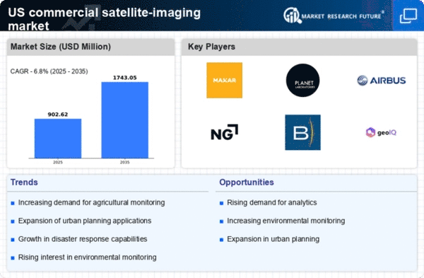
    As per MRFR analysis, the US commercial satellite-imaging market Size was estimated at 845.15 USD Million in 2024. The US commercial satellite-imaging market is projected to grow from 902.62 USD Million in 2025 to 1743.05 USD Million by 2035, exhibiting a compound annual growth rate (CAGR) of 6.8% during the forecast period 2025 - 2035.

    Key Market Trends & Highlights

    The US commercial satellite-imaging market is experiencing robust growth driven by technological advancements and increasing demand for geospatial data.

    • The rise of small satellites is reshaping the landscape of the US commercial satellite-imaging market.
    • Integration of AI and machine learning technologies is enhancing the capabilities of satellite imaging systems.
    • The evolving regulatory framework is facilitating new opportunities for market participants.
    • Increased demand for geospatial data and technological advancements in imaging systems are key drivers of market growth.

    Market Size & Forecast

    2024 Market Size 845.15 (USD Million)
    2035 Market Size 1743.05 (USD Million)

    Major Players

    Maxar Technologies (US), Planet Labs (US), Airbus (FR), Northrop Grumman (US), BlackSky (US), GeoIQ (US), Satellite Imaging Corporation (US), Spire Global (US)

    US Commercial Satellite Imaging Market Trends

    The commercial satellite-imaging market is currently experiencing a notable transformation, driven by advancements in technology and increasing demand for high-resolution imagery. The proliferation of small satellites, often referred to as CubeSats, has made it feasible to capture detailed images at a lower cost. This shift is likely to democratize access to satellite data, enabling a wider range of industries, including agriculture, urban planning, and environmental monitoring, to leverage this technology for enhanced decision-making. Furthermore, the integration of artificial intelligence and machine learning into image processing is enhancing the analytical capabilities of satellite data, allowing for more precise insights and predictions. In addition, the regulatory landscape surrounding satellite launches and operations is evolving, which may impact the commercial satellite-imaging market. The Federal Aviation Administration (FAA) and the National Oceanic and Atmospheric Administration (NOAA) are actively working to streamline processes and establish clearer guidelines for satellite operations. This regulatory clarity could foster innovation and investment in the sector, as companies seek to navigate the complexities of compliance while maximizing their operational efficiency. As the market continues to mature, collaboration between private entities and government agencies appears essential for addressing challenges and unlocking new opportunities in satellite imaging applications.

    Rise of Small Satellites

    The emergence of small satellites is reshaping the commercial satellite-imaging market. These compact devices, often launched in constellations, provide frequent and high-resolution imagery at reduced costs. Their agility allows for rapid deployment and adaptability to various applications, from disaster response to agricultural monitoring.

    Integration of AI and Machine Learning

    The incorporation of artificial intelligence and machine learning technologies into satellite data processing is enhancing the analytical capabilities of the commercial satellite-imaging market. This trend enables more accurate image interpretation, facilitating better decision-making across sectors such as urban planning and environmental management.

    Evolving Regulatory Framework

    The regulatory environment governing satellite operations is undergoing significant changes. Agencies like the FAA and NOAA are working to establish clearer guidelines, which may streamline processes for satellite launches and operations. This evolution could encourage investment and innovation within the commercial satellite-imaging market.

    US Commercial Satellite Imaging Market Drivers

    Emergence of New Market Players

    The commercial satellite-imaging market is experiencing a notable influx of new entrants, which is reshaping the competitive landscape. Startups and established companies are increasingly investing in satellite technology, leading to innovative solutions and services. This diversification is likely to enhance market dynamics, with projections indicating a growth rate of around 9% as competition intensifies. New players often focus on niche applications, such as disaster management and precision agriculture, which could expand the overall market reach. The entry of these companies fosters innovation and drives down costs, making satellite imagery more accessible to various sectors. This trend suggests a vibrant future for the commercial satellite-imaging market.

    Increased Demand for Geospatial Data

    The commercial satellite-imaging market experiences heightened demand for geospatial data across various sectors, including agriculture, urban planning, and environmental monitoring. As industries increasingly rely on accurate and timely data for decision-making, the market is projected to grow significantly. For instance, the agricultural sector utilizes satellite imagery to optimize crop yields and monitor land use, which could lead to a market expansion of approximately 15% annually. Furthermore, urban planners leverage this data to enhance infrastructure development, indicating a robust growth trajectory for the commercial satellite-imaging market. The integration of advanced analytics with satellite data further amplifies its utility, suggesting that the market will continue to evolve in response to these demands.

    Growing Interest in Climate Change Monitoring

    The commercial satellite-imaging market is increasingly recognized for its role in climate change monitoring and environmental management. Governments and organizations are investing in satellite technology to track changes in land use, deforestation, and greenhouse gas emissions. This focus on sustainability is likely to drive market growth, with estimates suggesting a potential increase of 10% in market size over the next few years. The ability to provide real-time data on environmental conditions enhances the effectiveness of climate policies and initiatives. As awareness of climate issues rises, the demand for satellite imagery to support research and policy-making is expected to expand, further solidifying the commercial satellite-imaging market's importance.

    Technological Advancements in Imaging Systems

    Technological innovations in imaging systems are driving the commercial satellite-imaging market forward. Enhanced sensor technologies, such as multispectral and hyperspectral imaging, provide more detailed and accurate data, which is crucial for various applications. The introduction of high-resolution imaging capabilities allows for better monitoring of environmental changes and urban development. As of 2025, the market is expected to witness a growth rate of around 12%, fueled by these advancements. Additionally, the development of smaller, more efficient satellites reduces operational costs, making satellite imagery more accessible to a broader range of industries. This trend indicates a promising future for the commercial satellite-imaging market as technology continues to evolve.

    Expansion of Defense and Security Applications

    The commercial satellite-imaging market is witnessing a surge in demand from defense and security sectors. Governments are increasingly utilizing satellite imagery for surveillance, reconnaissance, and intelligence gathering. This trend is likely to contribute to a market growth rate of approximately 8% annually. The ability to obtain high-resolution images of strategic locations enhances national security efforts and aids in disaster response planning. Moreover, the integration of satellite data with other intelligence sources improves situational awareness for defense agencies. As geopolitical tensions persist, the reliance on satellite imagery for security applications is expected to bolster the commercial satellite-imaging market significantly.

    Market Segment Insights

    By Application: Agriculture (Largest) vs. Disaster Management (Fastest-Growing)

    In the US commercial satellite-imaging market, the application segment is led by agriculture, which holds the largest market share due to its increasing reliance on satellite imagery for crop monitoring and farm management. This allows farmers to optimize yield and reduce costs by making data-driven decisions. Meanwhile, disaster management is rapidly gaining ground, using satellite imaging for real-time monitoring and assessment of natural disasters, thus capitalizing on advancements in technology and data analytics. The growth trends within this segment are largely attributed to advancements in technology, such as improved satellite imaging resolution and the proliferation of various analytical tools. Agriculture is consistently integrating these technologies to enhance productivity, whereas disaster management is influenced by increasing climate-related events, necessitating more robust imaging systems for effective response strategies. Consequently, both segments are poised for considerable growth in the coming years.

    Agriculture (Dominant) vs. Disaster Management (Emerging)

    Agriculture serves as the dominant application within the US commercial satellite-imaging market, characterized by its significant adoption across various farming practices. This segment leverages satellite imagery to enhance precision agriculture, allowing farmers to monitor crop health, soil conditions, and resource usage. The tools available for agricultural monitoring are becoming increasingly sophisticated, enabling farmers to make informed decisions based on real-time data. On the other hand, disaster management is an emerging application that is gaining attention owing to the rising frequency of natural disasters. This segment benefits from enhanced satellite capabilities that provide timely and accurate data for disaster response and recovery, showcasing its potential for growth as demand for effective disaster management solutions increases.

    By Technology: Optical Imaging (Largest) vs. Radar Imaging (Fastest-Growing)

    The US commercial satellite-imaging market shows a diverse array of technologies, with Optical Imaging commanding the largest share. This segment benefits from a broad range of applications such as environmental monitoring, urban planning, and agricultural assessments. Radar Imaging follows closely, distinguished by its ability to capture data in various weather conditions and during night-time, contributing to its rapid growth. Growth trends indicate a strong demand for timely and accurate imagery, with Radar Imaging emerging as the fastest-growing technology due to its capabilities in resilience against adverse conditions. Advances in technology and increasing governmental and commercial investments are further driving the expansion of both Optical and Radar Imaging segments, indicating robust potential for future growth in the market.

    Technology: Optical Imaging (Dominant) vs. Radar Imaging (Emerging)

    Optical Imaging stands out as the dominant technology in the segment, characterized by its high-resolution images that excel in providing detailed visual information. This technology is crucial for applications demanding clarity and precision, such as agricultural monitoring and infrastructure analysis. Conversely, Radar Imaging displays an emerging position within the market, utilizing synthetic aperture radar (SAR) technology to capture data regardless of weather conditions. This unique advantage allows for all-weather surveillance, making it increasingly attractive for various sectors, including defense and disaster management. As demand for comprehensive imaging solutions grows, both Optical Imaging and Radar Imaging are poised to play essential roles in shaping the landscape of satellite-based services.

    By End Use: Government (Largest) vs. Commercial Enterprises (Fastest-Growing)

    The US commercial satellite-imaging market is primarily dominated by the Government sector, which accounts for the largest share among all end users. Government entities leverage satellite imaging for national security, environmental monitoring, and disaster management. Following closely are Commercial Enterprises, which are observing a marked increase in adoption as the demand for accurate data to support business decisions grows. Research Institutions and Non-Profit Organizations constitute smaller segments, yet their contributions to niche applications remain significant. Growth trends in the US commercial satellite-imaging market are heavily influenced by advancements in satellite technology, decreasing costs, and an increasing array of applications. The Government sector is likely to see stable growth driven by ongoing investments in defense and environmental initiatives, while the Commercial Enterprises segment is expanding rapidly, fueled by the rise of analytics and the integration of satellite data into operational frameworks. Research Institutions are expected to play a pivotal role in innovation, while Non-Profit Organizations utilize imagery for social causes and humanitarian efforts.

    Government (Dominant) vs. Commercial Enterprises (Emerging)

    The Government sector is the dominant player in the commercial satellite-imaging market, leveraging high-resolution imagery for critical functions such as surveillance, intelligence, and resource management. This category benefits from stable funding and long-term projects that ensure sustainable demand. In contrast, Commercial Enterprises represent an emerging segment with rapidly growing interest in satellite imaging technologies. These enterprises utilize satellite data to enhance operational efficiencies, inform strategic decisions, and provide innovative services across various industries. While Government solutions tend to focus on security and compliance, commercial applications drive growth through new technology adaptations and market-oriented approaches, reflecting a dynamic shift in how satellite imagery is perceived and utilized.

    By Resolution: Very High Resolution (Largest) vs. High Resolution (Fastest-Growing)

    In the US commercial satellite-imaging market, the resolution segment is primarily dominated by Very High Resolution imaging, capturing a significant portion of the market share. This dominance can be attributed to the increasing demand for detailed and precise imagery in various sectors, including agriculture, urban planning, and national security. Following this, High Resolution imaging is emerging as the fastest-growing segment, benefiting from advancements in imaging technology and a rise in applications in environmental monitoring and disaster response. Growth trends in the resolution segment are fueled by technological developments, leading to improved imaging capabilities and resolutions. Factors such as increased investment in satellite manufacturing and the rising adoption of satellite imagery across industries are driving the market forward. Furthermore, the expanding use of AI and machine learning in image processing is enabling better data analytics, thus enhancing the overall value offered by satellite imagery services.

    Very High Resolution (Dominant) vs. Medium Resolution (Emerging)

    Very High Resolution imaging holds a dominant position in the US commercial satellite-imaging market due to its unparalleled clarity and detail, making it ideal for high-stakes applications such as defense and critical infrastructure monitoring. Its advanced capabilities allow for accurate assessments and decision-making in various sectors. In contrast, Medium Resolution imaging is recognized as an emerging player in this segment, offering a balance between detail and coverage at a lower cost. This segment is becoming increasingly attractive for industries that require timely and broad insights, such as agriculture and environmental studies, where high frequency and wider coverage are more critical than extreme detail.

    Get more detailed insights about US Commercial Satellite Imaging Market

    Key Players and Competitive Insights

    The commercial satellite-imaging market is characterized by a dynamic competitive landscape, driven by advancements in technology and increasing demand for high-resolution imagery across various sectors. Key players such as Maxar Technologies (US), Planet Labs (US), and Northrop Grumman (US) are at the forefront, each adopting distinct strategies to enhance their market positioning. Maxar Technologies (US) focuses on innovation through the development of advanced satellite systems, while Planet Labs (US) emphasizes rapid data acquisition and analysis capabilities. Northrop Grumman (US) leverages its extensive defense background to integrate satellite imaging with national security applications, thereby shaping a competitive environment that prioritizes technological advancement and strategic partnerships.

    In terms of business tactics, companies are increasingly localizing manufacturing and optimizing supply chains to enhance operational efficiency. The market structure appears moderately fragmented, with several players vying for market share. However, the collective influence of major companies like Maxar Technologies (US) and Planet Labs (US) suggests a trend towards consolidation, as these firms seek to expand their capabilities and service offerings through strategic collaborations and acquisitions.

    In October 2025, Maxar Technologies (US) announced a partnership with a leading AI firm to enhance its satellite imagery analytics capabilities. This collaboration aims to integrate machine learning algorithms into their imaging processes, potentially revolutionizing how data is interpreted and utilized across various industries. The strategic importance of this move lies in its potential to provide clients with more actionable insights, thereby increasing the value proposition of Maxar's offerings.

    In September 2025, Planet Labs (US) launched a new satellite constellation designed to provide daily global coverage with enhanced resolution. This initiative not only strengthens Planet's competitive edge but also aligns with the growing demand for timely and accurate data in sectors such as agriculture and urban planning. The strategic significance of this launch is underscored by the increasing reliance on satellite data for decision-making in critical areas, suggesting a robust future for Planet's services.

    In November 2025, Northrop Grumman (US) secured a contract with the US government to provide satellite imagery for defense applications. This contract highlights the company's strategic focus on national security and its ability to leverage its technological expertise in satellite systems. The implications of this contract extend beyond immediate revenue, as it positions Northrop Grumman as a key player in the defense sector, potentially leading to further opportunities in government contracts.

    As of November 2025, current trends in the commercial satellite-imaging market include a strong emphasis on digitalization, sustainability, and the integration of AI technologies. Strategic alliances are increasingly shaping the competitive landscape, as companies recognize the need for collaboration to drive innovation. Looking ahead, competitive differentiation is likely to evolve from traditional price-based competition towards a focus on technological innovation, reliability in supply chains, and the ability to deliver high-quality, actionable insights. This shift indicates a maturation of the market, where the ability to adapt and innovate will be paramount for sustained success.

    Key Companies in the US Commercial Satellite Imaging Market market include

    Industry Developments

    The US Commercial Satellite Imaging Market has seen significant developments recently, with notable activities from key players such as Northrop Grumman, Leonardo, and Maxar Technologies. In July 2023, Maxar completed a major acquisition of DigitalGlobe, enhancing its imaging capabilities and market share. Growth in market valuation has been driven by advancements in technology and increasing demand for satellite imagery for defense, agriculture, and urban planning. Notably, Planet Labs has announced multiple launches in 2023 aimed at increasing their satellite fleet, which contributes to data accessibility for various industries.

    Additionally, the partnership between NASA and HawkEye 360 focuses on utilizing satellite data for environmental monitoring and national security, reflecting the government's push towards leveraging commercial satellite data. Companies like Airbus Defence and Space and Inmarsat have also been active, exploring new collaborations to expand their services. Furthermore, between 2021 to 2023, there has been a growing emphasis on sustainability and climate monitoring, with government initiatives encouraging the integration of satellite technology into long-term environmental plans.

    Future Outlook

    US Commercial Satellite Imaging Market Future Outlook

    The commercial satellite-imaging market is projected to grow at a 6.8% CAGR from 2024 to 2035, driven by advancements in technology and increasing demand for data analytics.

    New opportunities lie in:

    • Development of AI-driven analytics platforms for enhanced data interpretation.
    • Expansion of subscription-based imaging services for continuous data access.
    • Partnerships with agricultural firms for precision farming solutions using satellite data.

    By 2035, the market is expected to achieve substantial growth, driven by innovative applications and strategic partnerships.

    Market Segmentation

    US Commercial Satellite Imaging Market End Use Outlook

    • Government
    • Commercial Enterprises
    • Research Institutions
    • Non-Profit Organizations

    US Commercial Satellite Imaging Market Resolution Outlook

    • Very High Resolution
    • High Resolution
    • Medium Resolution
    • Low Resolution

    US Commercial Satellite Imaging Market Technology Outlook

    • Optical Imaging
    • Radar Imaging
    • Hyperspectral Imaging
    • LiDAR

    US Commercial Satellite Imaging Market Application Outlook

    • Agriculture
    • Disaster Management
    • Environmental Monitoring
    • Urban Planning
    • Defense and Intelligence

    Report Scope

    MARKET SIZE 2024 845.15(USD Million)
    MARKET SIZE 2025 902.62(USD Million)
    MARKET SIZE 2035 1743.05(USD Million)
    COMPOUND ANNUAL GROWTH RATE (CAGR) 6.8% (2024 - 2035)
    REPORT COVERAGE Revenue Forecast, Competitive Landscape, Growth Factors, and Trends
    BASE YEAR 2024
    Market Forecast Period 2025 - 2035
    Historical Data 2019 - 2024
    Market Forecast Units USD Million
    Key Companies Profiled Maxar Technologies (US), Planet Labs (US), Airbus (FR), Northrop Grumman (US), BlackSky (US), GeoIQ (US), Satellite Imaging Corporation (US), Spire Global (US)
    Segments Covered Application, Technology, End Use, Resolution
    Key Market Opportunities Integration of artificial intelligence enhances data analysis capabilities in the commercial satellite-imaging market.
    Key Market Dynamics Technological advancements drive competitive dynamics in the commercial satellite-imaging market, enhancing data accuracy and accessibility.
    Countries Covered US

    Leave a Comment

    FAQs

    What is the projected market size of the US Commercial Satellite Imaging Market by 2035?

    By 2035, the US Commercial Satellite Imaging Market is expected to reach a value of 3.2 billion USD.

    What was the market value of the US Commercial Satellite Imaging Market in 2024?

    In 2024, the market value of the US Commercial Satellite Imaging Market is anticipated to be 1.4 billion USD.

    What is the expected CAGR for the US Commercial Satellite Imaging Market from 2025 to 2035?

    The expected compound annual growth rate for the market from 2025 to 2035 is 7.805 percent.

    What is the value of the US Commercial Satellite Imaging Market for Agriculture in 2024?

    In 2024, the US Commercial Satellite Imaging Market for Agriculture is valued at 0.35 billion USD.

    Which application segment is projected to grow the most by 2035 in the US Commercial Satellite Imaging Market?

    The Agriculture application segment is projected to reach 0.79 billion USD by 2035, showing significant growth.

    Who are the key players in the US Commercial Satellite Imaging Market?

    Major players in the market include Northrop Grumman, Maxar Technologies, and Planet Labs among others.

    What is the market value for the Disaster Management application in 2035?

    The market value for Disaster Management application is expected to reach 0.58 billion USD by 2035.

    How much is the Environmental Monitoring segment valued at in 2024?

    In 2024, the Environmental Monitoring segment of the market is valued at 0.3 billion USD.

    What is the projected value of the Defense and Intelligence segment by 2035?

    The Defense and Intelligence segment is projected to be valued at 0.6 billion USD by 2035.

    Which application segment is the smallest in value in 2024?

    Urban Planning is the smallest application segment, valued at 0.2 billion USD in 2024.

    Download Free Sample

    Kindly complete the form below to receive a free sample of this Report

    Case Study
    Chemicals and Materials

    Compare Licence

    ×
    Features License Type
    Single User Multiuser License Enterprise User
    Price $4,950 $5,950 $7,250
    Maximum User Access Limit 1 User Upto 10 Users Unrestricted Access Throughout the Organization
    Free Customization
    Direct Access to Analyst
    Deliverable Format
    Platform Access
    Discount on Next Purchase 10% 15% 15%
    Printable Versions