info@marketresearchfuture.com   📞 +1 (855) 661-4441(US)   📞 +44 1720 412 167(UK)   📞 +91 2269738890(APAC)
Certified Global Research Member
Isomar 1 Iso 1
Key Questions Answered
  • Global Market Outlook
  • In-depth analysis of global and regional trends
  • Analyze and identify the major players in the market, their market share, key developments, etc.
  • To understand the capability of the major players based on products offered, financials, and strategies.
  • Identify disrupting products, companies, and trends.
  • To identify opportunities in the market.
  • Analyze the key challenges in the market.
  • Analyze the regional penetration of players, products, and services in the market.
  • Comparison of major players financial performance.
  • Evaluate strategies adopted by major players.
  • Recommendations
Why Choose Market Research Future?
  • Vigorous research methodologies for specific market.
  • Knowledge partners across the globe
  • Large network of partner consultants.
  • Ever-increasing/ Escalating data base with quarterly monitoring of various markets
  • Trusted by fortune 500 companies/startups/ universities/organizations
  • Large database of 5000+ markets reports.
  • Effective and prompt pre- and post-sales support.

US Aerial Imaging Market Research Report: By Application (Agriculture, Construction, Environmental Monitoring, Mining, Real Estate), By Platform (Unmanned Aerial Vehicles, Manned Aircraft, Satellite, Ground-Based Systems), By Component (Camera, Software, Sensors, Data Storage, Transmitter) and By End Use (Commercial, Government, Military, Research) - Forecast to 2035


ID: MRFR/A&D/18023-US | 100 Pages | Author: Garvit Vyas| December 2023

US Aerial Imaging Market Research Report: By Application (Agriculture, Construction, Environmental Monitoring, Mining, Real Estate), By Platform (Unmanned Aerial Vehicles, Manned Aircraft, Satellite, Ground-Based Systems), By Component (Camera, Software, Sensors, Data Storage, Transmitter) and By End Use (Commercial, Government, Military, Research) - Forecast to 2035.


US Aerial Imaging Market Overview:


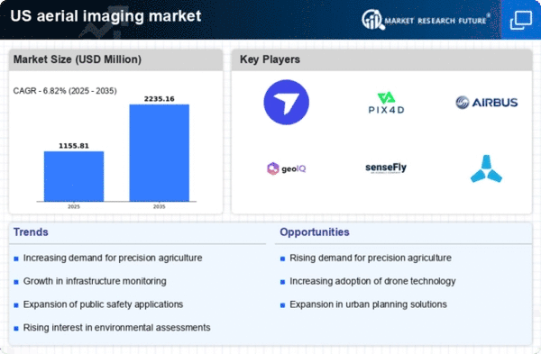
As per MRFR analysis, the US Aerial Imaging Market Size was estimated at 886.9 (USD Million) in 2023. The US Aerial Imaging Market Industry is expected to grow from 948.15(USD Million) in 2024 to 1,943.2 (USD Million) by 2035. The US Aerial Imaging Market CAGR (growth rate) is expected to be around 6.741% during the forecast period (2025 - 2035).


Key US Aerial Imaging Market Trends Highlighted


The US Aerial Imaging Market is experiencing notable trends influenced by technological advancements and increasing applications across various industries. Key market drivers include the demand for high-resolution aerial imagery in sectors like agriculture, real estate, and infrastructure planning. As organizations turn to data-driven decision-making, the relevance of aerial imaging has grown, utilizing technologies such as drones and satellite imagery. The push for precision agriculture, where farmers rely on aerial imaging for crop monitoring and management, highlights the critical role this market plays in enhancing productivity and sustainability in US farming practices.Opportunities to be explored center around the integration of artificial intelligence and machine learning with aerial imaging technology. This integration can enhance image analysis, automate data collection, and improve overall accuracy, making aerial imagery even more accessible and functional. Additionally, the rise in urbanization and rapid construction activities in the US fuels the need for regular site surveys and monitoring, sparking further adoption of aerial imaging solutions by urban planners and construction firms. Recent times have shown an emergence of trends like the regulatory framework opening up airspace for commercial drone operations, which increases the reach and usability of aerial imaging solutions.The US government has implemented new regulations that facilitate drone operations for commercial purposes, paving the way for innovative uses in emergency response, environmental monitoring, and public safety. These developments position the US Aerial Imaging Market for robust growth as more industries recognize the value of precise, aerial data collection in their operations.

US Aerial Imaging Market size

Source: Primary Research, Secondary Research, MRFR Database and Analyst Review


US Aerial Imaging Market Drivers

Increased Demand for Geographic Information Systems (GIS)


The US Aerial Imaging Market Industry is witnessing a significant rise due to the increased demand for Geographic Information Systems (GIS). The integration of aerial imaging technology within GIS is critical for data analysis and mapping in various sectors, including urban planning, environmental monitoring, and disaster management. According to the United States Geological Survey (USGS), the use of GIS data in environmental mapping has increased by over 40% in the last decade, highlighting a surging reliance on aerial imaging for real-time data and analysis.Established organizations such as the American Society for Photogrammetry and Remote Sensing (ASPRS) are advocating for the expansion of aerial imaging technologies in GIS applications. This heightened interest is propelling investment in aerial imaging systems, as businesses seek to optimize operations and enhance infrastructure projects. As cities expand and weather-related events become more frequent, the coupling of aerial imaging with GIS is poised to facilitate informed decision-making, ensuring sustainable growth and risk management in the US.


Technological Advancements in Drone Technology


Rapid advancements in drone technology are significantly driving growth in the US Aerial Imaging Market Industry. Drones equipped with high-resolution cameras and advanced sensor systems are becoming more accessible to various industries, enhancing their capability to capture detailed aerial imagery effortlessly. The Federal Aviation Administration (FAA) reported a 23% increase in registered drones in the US within the last year, showcasing a growing acceptance and reliance on drone technology across sectors.Organizations such as the Association for Unmanned Vehicle Systems International (AUVSI) forecast that commercial drone usage will see a compound annual growth rate of 16.4% up to 2025. This trend indicates that as aerial imaging systems become more sophisticated and cost-effective, their adoption in sectors ranging from agriculture to construction will continue to expand.


Government Initiatives and Funding for Smart Cities


Government initiatives aimed at developing smart cities are catalyzing the growth of the US Aerial Imaging Market Industry. Federal regulations and funding programs directed at enhancing urban infrastructure are increasingly incorporating aerial imaging technology. The US Department of Transportation (DOT) announced funding of approximately 15 billion USD for smart city projects over the next five years, which include leveraging aerial imaging for better urban mobility and safety solutions.Furthermore, the Smart City Challenge, facilitated by the DOT, promotes innovation in urban planning by utilizing aerial imaging data to address local issues effectively. These initiatives not only underscore the importance of aerial imaging in urban development but also assure continued investment and utilization in the coming years, thus driving the market forward.

US Aerial Imaging Market Segment Insights:

Aerial Imaging Market Application Insights


The Application segment of the US Aerial Imaging Market encompasses a wide array of uses that contribute significantly to its growth and relevance in today's economy. Agriculture holds a prominent position in this sector, where aerial imaging is utilized for precision farming, enabling farmers to monitor crop health, optimize yields, and manage resources effectively. The Construction industry benefits greatly from aerial imagery for project planning and monitoring progress, allowing for efficient management of timelines and resources. Environmental Monitoring is another vital application, driven by increasing regulatory requirements to protect ecosystems, which necessitate accurate data collection for habitat assessments, pollution tracking, and disaster management.In the Mining sector, aerial imaging plays a crucial role in surveying land, assessing mineral deposits, and ensuring compliance with safety regulations. Real Estate is also leveraging aerial imaging to provide potential buyers with comprehensive views of properties, thereby enhancing listings and support property valuations. The growth of the US Aerial Imaging Market is notably influenced by advancements in drone technology, which enhance image quality and reduce operational costs across these applications. Additionally, the increasing demand for detailed visual data in various industries propels market growth as stakeholders seek innovative solutions to improve efficiency and decision-making processes.As technology evolves, emerging trends in data analytics and machine learning further enhance the capabilities of aerial imaging, offering unprecedented opportunities for all applications within the sector. By integrating these technologies, various industries can derive more actionable insights from aerial images, driving market innovation and adoption. With a growing recognition of the value of aerial imaging data in optimizing operations, addressing regulatory demands, and improving service delivery, the US Aerial Imaging Market is expected to thrive, fueled by its diverse applications across multiple sectors.


US Aerial Imaging Market segment

Source: Primary Research, Secondary Research, MRFR Database and Analyst Review

Aerial Imaging Market Platform Insights


The Platform segment of the US Aerial Imaging Market encompasses various technologies driving growth and innovation in the industry. Unmanned Aerial Vehicles (UAVs) are particularly important due to their versatility and cost-effectiveness, making them suitable for applications in agriculture, infrastructure inspection, and disaster management. Similarly, Manned Aircraft play a crucial role in delivering high-resolution data over larger areas, often being preferred for comprehensive surveys. Satellites are significant for their ability to capture vast geospatial information, contributing to environmental monitoring and urban planning efforts in the US.Ground-Based Systems complement aerial imaging by providing essential data integration and analysis solutions. As demand for precise geographical information continues to grow, technological advancements in these platforms will drive market growth, addressing challenges such as data accuracy and processing times. The increased adoption of these platforms reflects a broader trend toward utilizing aerial imagery in various sectors, enhancing decision-making processes across industries while ensuring compliance with regulatory standards in the US.

Aerial Imaging Market Component Insights


The Component segment of the US Aerial Imaging Market encompasses essential technologies that play a critical role in the collection and processing of aerial data. The Camera segment stands out as a key player, providing high-resolution imagery, which is crucial for applications like mapping, surveillance, and environmental monitoring. Software solutions are equally important, enabling users to analyze, process, and interpret the data collected from aerial imagery, which enhances decision-making capabilities across various industries. Sensors within this segment are vital for capturing diverse types of data, including thermal and multispectral information, catering to sectors such as agriculture and infrastructure.Data Storage solutions ensure that the vast amounts of data generated are securely stored and easily retrievable, which is essential for compliance and future analysis. Transmitters facilitate real-time data transfer, amplifying the speed of response in critical applications like disaster management. The growing demand for precision in various sectors has driven innovations in these components, making them significant for the overall growth of the US Aerial Imaging Market. This segment's evolution is expected to enhance operational efficiency and foster advancements in technology, thereby addressing the increasing needs of industries utilizing aerial data.

Aerial Imaging Market End Use Insights


The End Use segment of the US Aerial Imaging Market holds significant importance across various applications, reflecting the diverse needs of different sectors. The Commercial segment leverages aerial imaging for a range of applications, including real estate, agriculture, and environmental monitoring, showcasing its versatility and growing demand. Government usage is largely driven by urban planning and infrastructure management, where aerial data helps in efficient decision-making and resource allocation. In the Military sector, aerial imaging is crucial for surveillance, reconnaissance, and tactical operations, enhancing operational effectiveness.Research plays an essential role by utilizing aerial imaging data for environmental studies and urban research, representing a vital component for academic and scientific advancements. This segmentation not only highlights the diverse applications but also emphasizes the adaptability of aerial imaging technologies to meet the unique demands of each sector. The increasing advancements in imaging technologies continue to drive growth opportunities across these end uses, presenting substantial avenues for innovation and development within the US Aerial Imaging Market.

US Aerial Imaging Market Key Players and Competitive Insights:


The US Aerial Imaging Market is a dynamic and rapidly evolving sector driven by advancements in technology and growing applications across various industries, including agriculture, construction, real estate, and energy. With the increasing demand for high-resolution imagery and an ability to provide real-time data analysis, companies entering this market are continuously striving for innovation and differentiation to secure a competitive edge. This competitive landscape is also characterized by strategic alliances, technological collaborations, and mergers and acquisitions, which facilitate the enhancement of service offerings and market reach. As organizations leverage aerial imaging solutions for efficiency improvements and enhanced decision-making processes, understanding the competitive dynamics becomes critical for stakeholders aiming to thrive in this vibrant market.DroneBase has firmly established itself as a significant player in the US Aerial Imaging Market through its unique offerings and a strong focus on delivering drone-based imagery solutions. Positioned as a reliable partner for businesses, DroneBase effectively caters to sectors like real estate, construction, and insurance, providing quality aerial photography and data analytics. The company's strengths lie in its extensive network of certified drone pilots, enabling quick response times and localized support across the United States. Additionally, their user-friendly platform allows clients to easily access and manage aerial data, further cementing their position in the market. The company's ability to adapt to client needs and its commitment to quality fosters strong customer relationships, making DroneBase a noteworthy competitor in the aerial imaging domain.PrecisionHawk operates as a prominent entity within the US Aerial Imaging Market, offering comprehensive drone solutions that emphasize data collection and analysis. The company’s portfolio includes various services, such as aerial surveys, crop assessments, and infrastructure inspections, catering to diverse sectors like agriculture, energy, and construction. PrecisionHawk's strength lies in its proprietary software and analytics capabilities, which transform raw aerial data into meaningful insights, aiding clients in making strategic decisions. Furthermore, the company has been active in pursuing mergers and acquisitions to enhance its technological capabilities and expand its market presence, showcasing a robust growth strategy. PrecisionHawk's focus on innovation, backed by partnerships with key industry stakeholders, positions it effectively to continue evolving within the competitive landscape of the US aerial imaging market.


Key Companies in the US Aerial Imaging Market Include:

DroneBase


PrecisionHawk


Geospatial Corporation


Aerial Applications


Skycatch


DroneDeploy


Kespry


Vricon


SenseFly


Pix4D


DigitalGlobe


Nearmap


Planet Labs


Airbus


GeoIQ


US Aerial Imaging Market Industry Developments


In recent months, the US Aerial Imaging Market has witnessed notable developments, particularly with the steady growth in demand for aerial data collection and analysis. Companies such as DroneBase and PrecisionHawk have expanded their services to cater to sectors like agriculture, construction, and insurance, leveraging advancements in drone technology and software solutions. A significant merger was reported in October 2023, where DigitalGlobe and Nearmap announced a partnership to enhance their satellite and aerial imagery offerings, further solidifying their market position. The increased investment in aerial imaging technologies has led to a market valuation surge, with major firms like Planet Labs and Airbus forecasting substantial revenue growth driven by their innovative imaging solutions. Additionally, Vricon and GeoIQ are also enhancing their technological capabilities, contributing to a more competitive landscape in the market. The last couple of years have seen a notable influx of startups, boosting innovation and providing diversified services with real-time data analytics. Overall, the aerial imaging sector in the US is evolving rapidly, showcasing a robust trajectory driven by technological advancements and strategic collaborations among key players.


US Aerial Imaging Market Segmentation Insights

Aerial Imaging Market Application Outlook


Agriculture


Construction


Environmental Monitoring


Mining


Real Estate

Aerial Imaging Market Platform Outlook


Unmanned Aerial Vehicles


Manned Aircraft


Satellite


Ground-Based Systems

Aerial Imaging Market Component Outlook


Camera


Software


Sensors


Data Storage


Transmitter

Aerial Imaging Market End Use Outlook


Commercial


Government


Military


Research

Report Scope:
Report Attribute/Metric Source: Details
MARKET SIZE 2018 886.9(USD Million)
MARKET SIZE 2024 948.15(USD Million)
MARKET SIZE 2035 1943.2(USD Million)
COMPOUND ANNUAL GROWTH RATE (CAGR) 6.741% (2025 - 2035)
REPORT COVERAGE Revenue Forecast, Competitive Landscape, Growth Factors, and Trends
BASE YEAR 2024
MARKET FORECAST PERIOD 2025 - 2035
HISTORICAL DATA 2019 - 2024
MARKET FORECAST UNITS USD Million
KEY COMPANIES PROFILED DroneBase, PrecisionHawk, Geospatial Corporation, Aerial Applications, Skycatch, DroneDeploy, Kespry, Vricon, SenseFly, Pix4D, DigitalGlobe, Nearmap, Planet Labs, Airbus, GeoIQ
SEGMENTS COVERED Application, Platform, Component, End Use
KEY MARKET OPPORTUNITIES Infrastructure monitoring advancements, Precision agriculture integration, Emergency response enhancements, Real estate marketing innovations, Environmental conservation assessments
KEY MARKET DYNAMICS Technological advancements in imaging, Increasing demand for GIS applications, Growing need for surveillance and security, Expanding drone usage in mapping, Rise in environmental monitoring initiatives
COUNTRIES COVERED US


Frequently Asked Questions (FAQ) :

The US Aerial Imaging Market is expected to be valued at 948.15 million USD in 2024.

By 2035, the US Aerial Imaging Market is projected to reach 1943.2 million USD.

The expected CAGR for the US Aerial Imaging Market from 2025 to 2035 is 6.741%.

In 2024, the Real Estate application holds the largest market share, valued at 278.15 million USD.

The Agriculture application is expected to grow to 400.0 million USD by 2035.

Key players in the market include DroneBase, PrecisionHawk, Geospatial Corporation, and Skycatch.

The Environmental Monitoring application is expected to have a market value of 180.0 million USD in 2024.

The Construction application is expected to reach a market value of 300.0 million USD by 2035.

The Mining application is projected to have a market value of 140.0 million USD in 2024.

The market presents growth opportunities in agriculture, construction, and environmental monitoring applications due to increasing adoption.

Leading companies partner with us for data-driven Insights.

clients

Kindly complete the form below to receive a free sample of this Report

We do not share your information with anyone. However, we may send you emails based on your report interest from time to time. You may contact us at any time to opt-out.

report-img
Tailored for You
  • Dedicated Research on any specifics segment or region.
  • Focused Research on specific players in the market.
  • Custom Report based only on your requirements.
  • Flexibility to add or subtract any chapter in the study.
  • Historic data from 2014 and forecasts outlook till 2040.
  • Flexibility of providing data/insights in formats (PDF, PPT, Excel).
  • Provide cross segmentation in applicable scenario/markets.