• Cat-intel
  • MedIntelliX
  • Resources
  • About Us
  • Request Free Sample ×

    Kindly complete the form below to receive a free sample of this Report

    Leading companies partner with us for data-driven Insights

    clients tt-cursor
    Hero Background

    Satellite Image Data Service Market

    ID: MRFR/A&D/31537-HCR
    128 Pages
    Sejal Akre
    October 2025

    Satellite Image Data Service Market Research Report By Application (Agriculture, Urban Planning, Environmental Monitoring, Disaster Management, Defense and Intelligence), By Type of Satellite (Optical Satellite, Synthetic Aperture Radar Satellite, Multispectral Satellite, Hyperspectral Satellite), By Delivery Model (Cloud-Based, On-Premises, Hybrid), By End Use (Government, Commercial, Research Institutions, Non-Profit Organizations) and By Regional (North America, Europe, South America, Asia Pacific, Middle East and Africa) - Forecast to 2035.

    Share:
    Download PDF ×

    We do not share your information with anyone. However, we may send you emails based on your report interest from time to time. You may contact us at any time to opt-out.

    Satellite Image Data Service Market Infographic

    Satellite Image Data Service Market Summary

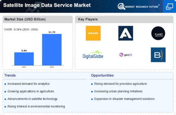
    As per MRFR analysis, the Satellite Image Data Service Market was estimated at 4.845 USD Billion in 2024. The Satellite Image Data Service industry is projected to grow from 5.249 USD Billion in 2025 to 11.7 USD Billion by 2035, exhibiting a compound annual growth rate (CAGR) of 8.34 during the forecast period 2025 - 2035.

    Key Market Trends & Highlights

    The Satellite Image Data Service Market is experiencing robust growth driven by technological advancements and increasing demand for geospatial data.

    • Technological advancements in imaging are enhancing the quality and accessibility of satellite data.
    • North America remains the largest market, while Asia-Pacific is emerging as the fastest-growing region in satellite image data services.
    • The agriculture segment leads in market size, whereas urban planning is witnessing the fastest growth due to rising urbanization.
    • Growing demand for geospatial data and advancements in satellite technology are key drivers propelling market expansion.

    Market Size & Forecast

    2024 Market Size 4.845 (USD Billion)
    2035 Market Size 11.7 (USD Billion)
    CAGR (2025 - 2035) 8.34%

    Major Players

    Maxar Technologies (US), Airbus Defence and Space (DE), Planet Labs (US), DigitalGlobe (US), GeoIQ (US), BlackSky (US), European Space Agency (EU), Satellite Imaging Corporation (US), SkyWatch (CA)

    Satellite Image Data Service Market Trends

    The Satellite Image Data Service Market is currently experiencing a dynamic evolution, driven by advancements in technology and increasing demand across various sectors. The proliferation of satellite imagery applications in agriculture, urban planning, and environmental monitoring appears to be reshaping the landscape of this market. As organizations seek to leverage high-resolution images for decision-making, the integration of artificial intelligence and machine learning into image analysis is becoming more prevalent. This trend suggests a shift towards more sophisticated data interpretation, enhancing the value derived from satellite imagery. Moreover, the growing emphasis on sustainability and climate change mitigation is likely to propel the demand for satellite data services. Governments and private entities are increasingly utilizing satellite imagery to monitor environmental changes, assess natural disasters, and manage resources more effectively. This heightened focus on environmental stewardship indicates a promising future for the Satellite Image Data Service Market, as stakeholders recognize the potential of satellite data in addressing global challenges. As the market continues to mature, collaboration between technology providers and end-users may foster innovative solutions that further expand the applications of satellite imagery in diverse fields.

    Technological Advancements in Imaging

    Recent innovations in satellite technology are enhancing the quality and accessibility of imagery. The introduction of high-resolution sensors and improved data processing techniques is enabling more detailed and accurate images. This trend is likely to attract a broader range of industries seeking precise data for analysis.

    Increased Demand for Environmental Monitoring

    There is a growing recognition of the importance of satellite imagery in tracking environmental changes. Organizations are increasingly utilizing satellite data to monitor deforestation, urban sprawl, and climate patterns. This trend suggests a shift towards more proactive environmental management strategies.

    Integration of AI and Machine Learning

    The incorporation of artificial intelligence and machine learning into satellite image analysis is transforming the way data is interpreted. These technologies are facilitating faster and more accurate insights, which may lead to enhanced decision-making processes across various sectors.

    The increasing demand for satellite imagery in various sectors, including agriculture, urban planning, and disaster management, underscores the pivotal role of satellite image data services in enhancing decision-making processes.

    U.S. Geological Survey (USGS)

    Satellite Image Data Service Market Drivers

    Rising Environmental Concerns

    The Satellite Image Data Service Market is increasingly influenced by rising environmental concerns and the need for sustainable practices. Governments and organizations are utilizing satellite imagery to monitor deforestation, track climate change, and assess natural disasters. This trend is reflected in the growing investment in Earth observation programs, which are expected to exceed USD 30 billion by 2025. The ability to gather real-time data on environmental changes enables better policy-making and resource management. As awareness of environmental issues continues to grow, the demand for satellite imagery to support conservation efforts and compliance with environmental regulations is likely to increase, further driving the Satellite Image Data Service Market.

    Growing Demand for Geospatial Data

    The Satellite Image Data Service Market is experiencing a notable surge in demand for geospatial data across various sectors. Industries such as agriculture, urban planning, and disaster management increasingly rely on satellite imagery for decision-making and operational efficiency. According to recent estimates, the market for geospatial data is projected to reach USD 100 billion by 2026, indicating a robust growth trajectory. This demand is driven by the need for accurate and timely information to support sustainable development and resource management. As organizations recognize the value of satellite imagery in enhancing situational awareness, the Satellite Image Data Service Market is likely to expand, offering innovative solutions tailored to specific industry needs.

    Advancements in Satellite Technology

    Technological innovations in satellite systems are significantly influencing the Satellite Image Data Service Market. The development of high-resolution imaging satellites and the deployment of small satellites, or CubeSats, have enhanced the quality and accessibility of satellite imagery. These advancements allow for more frequent data collection and improved image resolution, which are crucial for applications such as urban monitoring and environmental assessments. The market is expected to witness a compound annual growth rate of approximately 15% over the next five years, driven by these technological improvements. As satellite technology continues to evolve, the Satellite Image Data Service Market is poised to benefit from increased capabilities and reduced costs, making satellite imagery more accessible to a wider range of users.

    Increased Investment in Defense and Security

    The Satellite Image Data Service Market is also benefiting from increased investment in defense and security applications. Governments worldwide are recognizing the strategic importance of satellite imagery for national security, border surveillance, and military operations. The defense sector is projected to allocate over USD 20 billion to satellite-based reconnaissance and surveillance systems by 2026. This investment is driven by the need for enhanced situational awareness and intelligence gathering capabilities. As geopolitical tensions rise, the reliance on satellite imagery for defense purposes is likely to grow, providing a significant boost to the Satellite Image Data Service Market.

    Integration of Satellite Data in Smart Cities

    The concept of smart cities is gaining traction, and the Satellite Image Data Service Market plays a pivotal role in this development. Urban planners and local governments are increasingly leveraging satellite imagery to enhance infrastructure planning, traffic management, and public safety. The integration of satellite data with other technologies, such as IoT and big data analytics, allows for more informed decision-making and efficient resource allocation. As cities strive to become more sustainable and livable, the demand for satellite imagery is expected to rise. The market for smart city solutions is projected to reach USD 1 trillion by 2025, indicating a substantial opportunity for the Satellite Image Data Service Market to contribute to urban development initiatives.

    Market Segment Insights

    By Application: Agriculture (Largest) vs. Urban Planning (Fastest-Growing)

    The Satellite Image Data Service Market is largely dominated by the agriculture segment, which significantly benefits from high-resolution imagery for precision farming and crop monitoring. Urban planning follows as a substantial application area, supported by increased urbanization and the need for smart city initiatives. This dual dominance reflects the diverse utility of satellite imagery across sectors, with agriculture taking a commanding lead while urban planning rapidly expands its footprint in the market.

    Agriculture (Dominant) vs. Urban Planning (Emerging)

    Agriculture remains the dominant application of satellite image data services, facilitating crop health monitoring, yield prediction, and resource management. This sector leverages advanced satellite technologies to optimize agricultural practices, ensuring sustainability and efficiency. On the other hand, urban planning is an emerging application that is gaining traction due to the increasing need for data-driven decision-making in developing urban infrastructures. Urban planners utilize satellite imagery to assess land use, monitor environmental changes, and streamline urban development processes, making this field a vital component of future growth in the satellite image data market.

    By Type of Satellite: Optical Satellite (Largest) vs. Synthetic Aperture Radar Satellite (Fastest-Growing)

    The Satellite Image Data Service Market is currently dominated by Optical Satellites, which capture high-resolution images that are precise and detailed, making them highly sought after for various applications including agriculture, urban planning, and environmental monitoring. Synthetic Aperture Radar (SAR) Satellites, while smaller in market share, are gaining traction as they provide uninterrupted imaging capabilities regardless of weather conditions, appealing to sectors that require consistent surveillance, like defense and disaster management. In recent years, the growth of Optical Satellites has been driven by increasing demand for high-resolution earth observation data. The advancements in camera technologies and satellites' capabilities to capture minute details have made this segment flourish. On the other hand, SAR Satellites are experiencing rapid growth due to their ability to operate day and night in any weather, meeting the demand for reliable data in various industries, thus positioning them as a crucial technological advancement in satellite imaging.

    Optical Satellite (Dominant) vs. Hyperspectral Satellite (Emerging)

    Optical Satellites have established themselves as the dominant player in the Satellite Image Data Service Market. Their capability to capture visually appealing and detailed imagery makes them essential in sectors like agriculture, forestry, and urban development, where visual information is crucial. Recently, they have also been integrating advanced technologies such as artificial intelligence to enhance image analysis and interpretation. In contrast, Hyperspectral Satellites, which capture data across numerous wavelengths, represent an emerging segment. Although currently less extensive in application, their advanced capabilities for material and color differentiation hold significant potential. They are increasingly being developed for specialized applications like mineral exploration, vegetation analysis, and water quality assessment, indicating a promising trajectory as industries become more data-driven.

    By Delivery Model: Cloud-Based (Largest) vs. On-Premises (Fastest-Growing)

    In the Satellite Image Data Service Market, the cloud-based delivery model holds the largest market share, primarily due to its scalability, accessibility, and cost-effectiveness. Organizations increasingly prefer cloud solutions as they offer easy integration with existing systems and facilitate real-time data access. On-premises solutions, while accounting for a smaller portion of the market, have shown significant interest from businesses that prioritize data security and control.

    Delivery Models: Cloud-Based (Dominant) vs. On-Premises (Emerging)

    Cloud-based delivery has become the dominant model in the Satellite Image Data Service Market due to its flexible infrastructure and the ability to store vast amounts of data efficiently. Clients are drawn to its benefits, such as reduced IT overhead and enhanced collaboration through remote access. Conversely, the on-premises model, characterized by a slower growth trajectory, is emerging as companies seek greater data sovereignty and protection against potential breaches. This model suits organizations that require stringent compliance and privacy regulations, maintaining a significant role while adapting to evolving technological demands.

    By End Use: Government (Largest) vs. Commercial (Fastest-Growing)

    In the Satellite Image Data Service Market, the distribution of market share reveals that the Government sector holds the largest share, driven by national security, disaster management, and urban planning initiatives. Government agencies utilize satellite imagery for strategic decision-making and monitoring environmental changes, showcasing their reliance on high-resolution data services. On the other hand, the Commercial sector is the fastest-growing segment, fueled by the rising demand for image data applications in sectors such as agriculture, real estate, and telecommunications.

    Government (Dominant) vs. Research Institutions (Emerging)

    The Government sector stands out as the dominant player in the Satellite Image Data Service Market, leveraging satellite imagery to enhance national security and emergency response capabilities. Government entities deploy satellite data for diverse applications, including geographic mapping and infrastructure management. In contrast, Research Institutions present an emerging segment driven by the increasing necessity for satellite data in environmental studies and climate research. These institutions are integrating advanced analytics with satellite imagery to provide insights crucial for scientific research. Both segments are integral to the market, with the Government being established and expansive, while Research Institutions are carving a niche that holds significant potential for innovation and development.

    Get more detailed insights about Satellite Image Data Service Market

    Regional Insights

    North America : Innovation and Leadership Hub

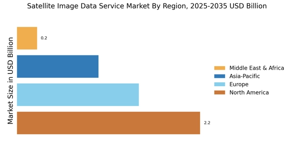
    North America leads the Satellite Image Data Service Market, holding approximately 45% of the global share, driven by technological advancements and a robust demand for high-resolution imagery. The region benefits from significant investments in satellite technology and favorable regulations that encourage innovation. The U.S. government’s initiatives to enhance satellite capabilities further bolster market growth, making it a key player in the global landscape. The United States is the largest market, with major players like Maxar Technologies, Planet Labs, and DigitalGlobe dominating the sector. Canada also plays a vital role, with companies like SkyWatch contributing to the competitive landscape. The presence of these key players fosters a dynamic environment, pushing for advancements in satellite imaging technology and expanding service offerings to various sectors, including agriculture, defense, and urban planning.

    Europe : Emerging Market with Potential

    Europe is witnessing a significant rise in the Satellite Image Data Service Market, accounting for about 30% of the global share. The region's growth is fueled by increasing demand for satellite data in environmental monitoring, urban planning, and disaster management. Regulatory frameworks, such as the European Space Agency's initiatives, are pivotal in promoting satellite technology and ensuring compliance with data privacy standards, thus enhancing market attractiveness. Leading countries in this region include Germany, France, and the UK, where companies like Airbus Defence and Space and the European Space Agency are at the forefront. The competitive landscape is characterized by collaborations between private firms and governmental organizations, fostering innovation and expanding service capabilities. This synergy is crucial for addressing the diverse needs of various industries, from agriculture to defense, ensuring a robust market presence.

    Asia-Pacific : Rapidly Growing Market

    Asia-Pacific is emerging as a rapidly growing market for Satellite Image Data Services, holding approximately 20% of the global share. The region's growth is driven by increasing investments in satellite technology and a rising demand for high-resolution imagery across various sectors, including agriculture, forestry, and urban development. Government initiatives aimed at enhancing satellite capabilities and data accessibility are significant catalysts for market expansion. Countries like China, India, and Japan are leading the charge, with a growing number of local companies entering the market. The competitive landscape is becoming increasingly dynamic, with players like GeoIQ and BlackSky making strides in providing innovative satellite solutions. The presence of these key players, along with supportive government policies, is expected to drive further growth and technological advancements in the region.

    Middle East and Africa : Emerging Opportunities Ahead

    The Middle East and Africa region is gradually emerging in the Satellite Image Data Service Market, currently holding about 5% of the global share. The growth is primarily driven by increasing awareness of the benefits of satellite imagery in sectors such as agriculture, mining, and urban planning. Government initiatives aimed at enhancing satellite capabilities and data utilization are crucial for fostering market development in this region. Countries like South Africa and the UAE are at the forefront, with investments in satellite technology and partnerships with global players. The competitive landscape is characterized by a mix of local and international companies, creating opportunities for collaboration and innovation. As the region continues to develop its satellite capabilities, the market is expected to expand, addressing the growing demand for satellite data services across various industries.

    Key Players and Competitive Insights

    The Satellite Image Data Service Market is currently characterized by a dynamic competitive landscape, driven by advancements in technology and increasing demand for high-resolution imagery across various sectors, including agriculture, urban planning, and disaster management. Key players such as Maxar Technologies (US), Airbus Defence and Space (DE), and Planet Labs (US) are at the forefront, each adopting distinct strategies to enhance their market positioning. Maxar Technologies (US) focuses on innovation through the development of advanced satellite systems, while Airbus Defence and Space (DE) emphasizes partnerships with governmental agencies to expand its service offerings. Planet Labs (US) leverages its extensive satellite constellation to provide frequent updates, catering to the growing need for timely data. Collectively, these strategies contribute to a competitive environment that is increasingly reliant on technological advancements and strategic collaborations.

    In terms of business tactics, companies are increasingly localizing their operations to better serve regional markets, optimizing supply chains to enhance efficiency, and investing in digital transformation initiatives. The market structure appears moderately fragmented, with several key players exerting influence while also facing competition from emerging firms. This fragmentation allows for a diverse range of services and innovations, fostering a competitive atmosphere that encourages continuous improvement and adaptation.

    In August 2025, Maxar Technologies (US) announced the launch of its next-generation satellite, which is expected to significantly enhance imaging capabilities and data processing speeds. This strategic move is likely to solidify Maxar's position as a leader in high-resolution satellite imagery, enabling it to meet the increasing demands of clients in sectors such as defense and environmental monitoring. The introduction of this technology may also provide a competitive edge in securing long-term contracts with governmental and commercial entities.

    In September 2025, Airbus Defence and Space (DE) entered into a partnership with a leading environmental organization to provide satellite imagery for climate monitoring initiatives. This collaboration underscores Airbus's commitment to sustainability and positions the company as a key player in addressing global environmental challenges. By aligning its services with pressing societal needs, Airbus is likely to enhance its brand reputation and attract new clients who prioritize sustainability in their operations.

    In July 2025, Planet Labs (US) expanded its data analytics capabilities by acquiring a technology firm specializing in artificial intelligence. This acquisition is expected to enhance Planet's ability to deliver actionable insights derived from satellite imagery, thereby increasing the value proposition for its customers. The integration of AI into its services may also allow Planet to differentiate itself in a crowded market, appealing to clients seeking advanced analytical tools to inform decision-making processes.

    As of October 2025, the competitive trends within the Satellite Image Data Service Market are increasingly defined by digitalization, sustainability, and the integration of artificial intelligence. Strategic alliances are playing a crucial role in shaping the current landscape, as companies seek to combine their strengths to address complex challenges. Looking ahead, it appears that competitive differentiation will evolve from traditional price-based competition to a focus on innovation, technological advancements, and the reliability of supply chains. This shift may ultimately redefine how companies position themselves in the market, emphasizing the importance of delivering unique value propositions to clients.

    Key Companies in the Satellite Image Data Service Market market include

    Industry Developments

    • Q2 2024: Axelspace and Liberatech Collaborate to Integrate Satellite Data with AI Analytics Axelspace announced a partnership with Liberatech in May 2024 to combine satellite image data with AI-powered analytics, aiming to deliver advanced geospatial insights for applications such as agriculture and urban planning.
    • Q2 2024: SES Achieves Sub-Ten-Second Delay from Contact to Cloud Bucket for High-Resolution Imagery Bursts SES reported in 2024 the commissioning of new Ka-band and optical ground stations interconnected via software-defined networks, enabling rapid downlink and cloud integration for satellite image data services.
    • Q2 2024: Planet Labs Announces Launch of Next-Generation Earth Observation Satellites Planet Labs launched a new fleet of high-resolution Earth observation satellites in April 2024, expanding its capacity to deliver satellite image data services for commercial and government clients.
    • Q2 2024: ICEYE Secures Multi-Year Contract with European Government for Flood Monitoring via Satellite Imagery ICEYE announced in May 2024 a multi-year contract win with a European government agency to provide real-time flood monitoring using its synthetic aperture radar satellite image data services.
    • Q2 2024: Maxar Technologies Wins Contract to Provide Satellite Imagery for U.S. Department of Defense Maxar Technologies secured a contract in June 2024 to supply high-resolution satellite image data to the U.S. Department of Defense for intelligence and operational planning.
    • Q3 2024: Ursa Space Systems Announces Partnership with AWS for Cloud-Based Satellite Image Analytics Ursa Space Systems announced in July 2024 a partnership with Amazon Web Services to deliver scalable satellite image analytics through cloud-based platforms.
    • Q3 2024: Airbus Launches New Pléiades Neo Satellite for Enhanced Earth Observation Data Services Airbus launched the latest Pléiades Neo satellite in August 2024, increasing its capacity to provide high-resolution satellite image data for commercial and government customers.
    • Q3 2024: Planet Labs Announces Executive Appointment: New Chief Technology Officer Planet Labs appointed a new Chief Technology Officer in July 2024 to lead innovation in satellite image data services and analytics.
    • Q4 2024: L3Harris Technologies Wins Contract to Provide Satellite Data Services for Disaster Response L3Harris Technologies announced in October 2024 a contract win to supply satellite image data for disaster response and recovery operations in North America.
    • Q1 2025: Trimble Inc. Partners with Satellite Imaging Corporation to Expand Geospatial Data Offerings Trimble Inc. announced a partnership with Satellite Imaging Corporation in January 2025 to enhance its geospatial data services using advanced satellite imagery.
    • Q2 2025: Maxar Technologies Announces Opening of New Satellite Data Processing Facility Maxar Technologies opened a new facility in May 2025 dedicated to processing and delivering satellite image data services to global clients.
    • Q2 2025: ICEYE Raises $100 Million in Series D Funding to Expand Satellite Data Services ICEYE announced in June 2025 the completion of a $100 million Series D funding round to accelerate the expansion of its satellite image data service offerings.

    Future Outlook

    Satellite Image Data Service Market Future Outlook

    The Satellite Image Data Service Market is projected to grow at an 8.34% CAGR from 2024 to 2035, driven by advancements in technology, increasing demand for geospatial data, and applications in various sectors.

    New opportunities lie in:

    • Development of AI-driven analytics platforms for enhanced data interpretation.
    • Expansion of subscription-based models for continuous data access.
    • Partnerships with governmental agencies for disaster management and environmental monitoring.

    By 2035, the market is expected to be robust, driven by innovation and diverse applications.

    Market Segmentation

    Satellite Image Data Service Market End Use Outlook

    • Government
    • Commercial
    • Research Institutions
    • Non-Profit Organizations

    Satellite Image Data Service Market Application Outlook

    • Agriculture
    • Urban Planning
    • Environmental Monitoring
    • Disaster Management
    • Defense and Intelligence

    Satellite Image Data Service Market Delivery Model Outlook

    • Cloud-Based
    • On-Premises
    • Hybrid

    Satellite Image Data Service Market Type of Satellite Outlook

    • Optical Satellite
    • Synthetic Aperture Radar Satellite
    • Multispectral Satellite
    • Hyperspectral Satellite

    Report Scope

    MARKET SIZE 20244.845(USD Billion)
    MARKET SIZE 20255.249(USD Billion)
    MARKET SIZE 203511.7(USD Billion)
    COMPOUND ANNUAL GROWTH RATE (CAGR)8.34% (2024 - 2035)
    REPORT COVERAGERevenue Forecast, Competitive Landscape, Growth Factors, and Trends
    BASE YEAR2024
    Market Forecast Period2025 - 2035
    Historical Data2019 - 2024
    Market Forecast UnitsUSD Billion
    Key Companies ProfiledMarket analysis in progress
    Segments CoveredMarket segmentation analysis in progress
    Key Market OpportunitiesIntegration of artificial intelligence enhances data analysis capabilities in the Satellite Image Data Service Market.
    Key Market DynamicsTechnological advancements and regulatory changes drive competitive dynamics in the Satellite Image Data Service Market.
    Countries CoveredNorth America, Europe, APAC, South America, MEA

    Leave a Comment

    FAQs

    What is the projected market valuation of the Satellite Image Data Service Market by 2035?

    The Satellite Image Data Service Market is projected to reach a valuation of 11.7 USD Billion by 2035.

    What was the market valuation of the Satellite Image Data Service Market in 2024?

    In 2024, the market valuation of the Satellite Image Data Service Market was 4.845 USD Billion.

    What is the expected CAGR for the Satellite Image Data Service Market during the forecast period 2025 - 2035?

    The expected CAGR for the Satellite Image Data Service Market during the forecast period 2025 - 2035 is 8.34%.

    Which companies are considered key players in the Satellite Image Data Service Market?

    Key players in the Satellite Image Data Service Market include Maxar Technologies, Airbus Defence and Space, Planet Labs, and DigitalGlobe.

    What are the main application segments of the Satellite Image Data Service Market?

    The main application segments include Agriculture, Urban Planning, Environmental Monitoring, Disaster Management, and Defense and Intelligence.

    How much is the Agriculture segment projected to grow by 2035?

    The Agriculture segment is projected to grow from 0.9 USD Billion in 2024 to 2.1 USD Billion by 2035.

    What delivery models are utilized in the Satellite Image Data Service Market?

    The delivery models utilized include Cloud-Based, On-Premises, and Hybrid models.

    What is the projected growth for the Hybrid delivery model by 2035?

    The Hybrid delivery model is projected to grow from 2.145 USD Billion in 2024 to 5.4 USD Billion by 2035.

    Which end-use segments are included in the Satellite Image Data Service Market?

    End-use segments include Government, Commercial, Research Institutions, and Non-Profit Organizations.

    Download Free Sample

    Kindly complete the form below to receive a free sample of this Report

    Case Study
    Chemicals and Materials

    Compare Licence

    ×
    Features License Type
    Single User Multiuser License Enterprise User
    Price $4,950 $5,950 $7,250
    Maximum User Access Limit 1 User Upto 10 Users Unrestricted Access Throughout the Organization
    Free Customization
    Direct Access to Analyst
    Deliverable Format
    Platform Access
    Discount on Next Purchase 10% 15% 15%
    Printable Versions