Market Analysis
In-depth Analysis of Mobile Mapping Market Industry Landscape
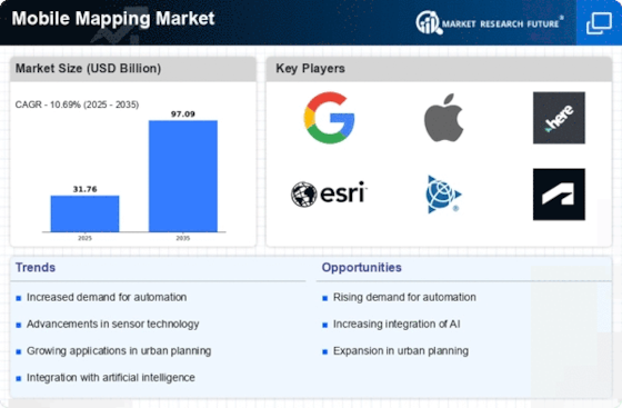
In recent years, the mobile mapping market has undergone significant growth and transformation, fueled by advancements in mobile technology, the proliferation of smartphones and tablets, and the increasing demand for location-based services. Mobile mapping refers to the process of collecting geospatial data using mobile devices equipped with GPS, cameras, and other sensors to create detailed maps and navigate the physical world. One prominent trend in this market is the integration of augmented reality (AR) and virtual reality (VR) technologies into mobile mapping applications. These technologies enhance the user experience by overlaying digital information and graphics onto real-world environments, providing users with immersive and interactive mapping experiences for navigation, gaming, tourism, and other applications.
Another notable trend is the adoption of crowd-sourced mapping and collaborative mapping platforms. With the rise of social media, location-sharing apps, and community-driven platforms such as OpenStreetMap, there is a growing trend towards leveraging crowd-sourced data and user-generated content to enhance the accuracy and completeness of maps. Mobile mapping applications that allow users to contribute data, update maps in real-time, and collaborate with others enable organizations to crowd-source mapping tasks, collect data from diverse sources, and create dynamic and up-to-date maps that reflect the changing landscape of cities, roads, and points of interest.
Furthermore, there is a growing demand for indoor mapping solutions driven by the increasing adoption of indoor positioning systems (IPS) and the growing need for indoor navigation and location-based services in venues such as shopping malls, airports, hospitals, and office buildings. Mobile mapping applications that support indoor mapping and indoor navigation enable users to navigate complex indoor environments, locate points of interest, and access location-based services such as indoor wayfinding, asset tracking, and proximity marketing. Indoor mapping solutions also provide opportunities for businesses to enhance customer engagement, improve operational efficiency, and optimize space utilization in indoor environments.
Additionally, the integration of mobile mapping with other emerging technologies such as 5G, Internet of Things (IoT), and artificial intelligence (AI) is driving innovation in the mobile mapping market. 5G networks offer higher bandwidth, lower latency, and greater reliability, enabling faster data transmission and real-time processing of geospatial data on mobile devices. IoT devices such as drones, autonomous vehicles, and smart sensors generate vast amounts of geospatial data that can be collected, analyzed, and integrated into mobile mapping applications to provide insights into traffic patterns, environmental conditions, and infrastructure assets. AI algorithms and machine learning techniques are being used to analyze geospatial data, extract meaningful insights, and automate mapping tasks such as object recognition, feature extraction, and map annotation.
Moreover, there is a growing focus on privacy and security in the mobile mapping market, driven by concerns over data privacy, surveillance, and cybersecurity. With the increasing collection and sharing of location data through mobile devices and mapping applications, there is a need for robust privacy controls, data encryption, and secure transmission protocols to protect sensitive location information from unauthorized access, misuse, and exploitation. Mobile mapping companies are implementing privacy-enhancing technologies such as anonymization, differential privacy, and geofencing to safeguard user privacy and comply with regulations such as GDPR and CCPA.
Lastly, the COVID-19 pandemic has accelerated the adoption of mobile mapping solutions for contact tracing, public health surveillance, and pandemic response efforts. Mobile mapping applications that leverage GPS, Bluetooth, and other location-based technologies enable governments, healthcare organizations, and public health agencies to track the spread of the virus, monitor compliance with social distancing measures, and identify high-risk areas and populations. Mobile mapping companies are collaborating with public health authorities to develop and deploy mapping solutions that support contact tracing, outbreak detection, and vaccination distribution efforts, helping to mitigate the impact of the pandemic and protect public health and safety.


Leave a Comment