info@marketresearchfuture.com   📞  +1 (855) 661-4441(US)   📞  +44 1720 412 167(UK)
Certified Global Research Member
Isomar fd.webp Wcrc 57.webp
Key Questions Answered
  • Global Market Outlook
  • In-depth analysis of global and regional trends
  • Analyze and identify the major players in the market, their market share, key developments, etc.
  • To understand the capability of the major players based on products offered, financials, and strategies.
  • Identify disrupting products, companies, and trends.
  • To identify opportunities in the market.
  • Analyze the key challenges in the market.
  • Analyze the regional penetration of players, products, and services in the market.
  • Comparison of major players’ financial performance.
  • Evaluate strategies adopted by major players.
  • Recommendations
Why Choose Market Research Future?
  • Vigorous research methodologies for specific market.
  • Knowledge partners across the globe
  • Large network of partner consultants.
  • Ever-increasing/ Escalating data base with quarterly monitoring of various markets
  • Trusted by fortune 500 companies/startups/ universities/organizations
  • Large database of 5000+ markets reports.
  • Effective and prompt pre- and post-sales support.

Hydrographic Survey Equipment Market Share

ID: MRFR//8146-HCR | 168 Pages | Author: Sejal Akre| November 2024

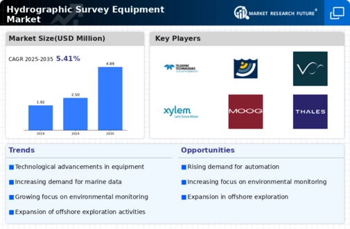
The hydrographic survey equipment market is characterized by noticeable tendencies that portray the changing nature of maritime activities, environmental monitoring and underwater mapping. One of the main trends is towards the adoption of cutting-edge technologies in hydrographic survey equipment. High resolution multibeam and single-beam echo sounders, LiDAR (Light Detection and Ranging) airborne systems, as well as autonomous underwater vehicles (AUVs), are now essential components in hydrographic survey systems. This marks a move to more accurate and efficient approaches of collecting data which would enable hydrographers to acquire detailed and precise information about bathymetry that can be applicable for various purposes including navigation, offshore exploration and coastal management.

Another important trend is the incorporation of artificial intelligence (AI) and machine learning (ML) into hydrographic survey data analysis. The industry has resorted to AI and ML algorithms to automate data interpretation, recognize patterns from large sets of data, thus improving efficiency on information retrieval as a result of increasing volume of collected hydrographic survey data. It ultimately results in faster interpretation process; greater accuracy when mapping submerged features; ability to detect subtle alterations at the sea floor or within water column hence providing useful hints on scientific research as well as marine infrastructure development.

Additionally, there is a rising preference for unmanned survey vessels and remotely operated vehicles (ROVs) in conducting hydrographic surveys. These platforms are either autonomous or remotely controlled with advanced sensors and other kinds of devices which facilitate their access to hazardous environments or those difficult-to-reach spots during surveys. This trend enhances surveyor productivity while reducing operational costs plus it minimizes human divers or people-operated vessels needed for certain types of surveys.

Mobile mapping systems are increasingly being sought after in Hydrographic Survey Equipment market. These integrated GNSS (Global Navigation Satellite System) based systems allow hydrographic surveyors to obtain georeferenced information even when they are on land, in shallow waters or along shores. Mobile mapping systems enhance the flexibility and speed of survey operations, providing real-time data for applications such as port and harbor management, environmental monitoring, and infrastructure planning.

Moreover, hydrographic survey equipment is affected by the global quest for environmental sustainability. The resultant demand for eco-friendly surveying equipment is linked to efforts aimed at monitoring and mitigating human influences on marine ecosystems. Hydrographic instruments that are eco-efficient in terms of their footprint, energy-saving sensors or featuring sustainable manufacturing practices gain popularity in this market segment. This trend indicates commitment of the hydrographic community to responsible and environment-friendly surveying culture.

In addition, cloud-based data management and collaboration are emerging trends in the Hydrographic Survey Equipment market. Businesses now offer options that enable reliable storage, processing and sharing of the surveyed data within online spaces. Such development helps connect teams working from different locations with each other as well as with stakeholders irrespective of geographical position through internet based platforms. Furthermore this ensures access to a large chunk of information relating to various researches and planning hydrosurveys.

Furthermore augmented reality (AR) and virtual reality (VR) technologies are being incorporated into hydrographic surveying as a trend. Through these technologies it is possible to immerse hydrographer users into three-dimensional environments where they may interact with their data about surveys in motion. The use of AR/VR utilities during interpretation processes can simplify training events meant for performing surveys; also it would be helpful if several spatial details had to be explained to people who possess dissimilar levels of understanding them.

Not only this, but there is also an increasing trend of emphasizing more on cyber security in the market. As it has turned out to be more connected and data-intensive, survey equipment finds this a necessity for securing survey data, communication channels, as well as control systems against any form of cyber threats. This trend shows the industry’s dedication to keeping the privacy and trust of hydrographic survey information safe notably in areas such as naval operations, environmental monitoring and infrastructure planning.”

Covered Aspects:

Report Attribute/Metric Details
Base Year For Estimation   2019
Forecast Period   2028
Growth Rate   5.41% (2022-2030)

Global Hydrographic Survey Equipment Market Overview


Hydrographic Survey Equipment Market is projected to reach USD 3,760 Million by 2030 and register a CAGR of 5.41% forecast period 2022-2030.


Hydrographic survey is the science of measurement and description of factors that affect dredging, offshore oil exploration/offshore oil drilling, maritime navigation, marine construction, and related activities. It emphasizes on soundings, shorelines, tides, currents, seabed, and submerged obstructions that relate to the previously mentioned activities.


Market Synopsis


The Hydrographic Survey Equipment Market is expected to register significant growth during the forecast period owing to factors such as increasing maritime trade and demand for accurate nautical charts. Furthermore, the growing use of UUVs and USVs to conduct hydrographic and oil & gas surveys is also expected to drive the market growth. Additionally, many countries across the world are increasingly adopting hydrographic survey vessels to create nautical charts, which is projected to fuel the growth of the Hydrographic Survey Equipment Market. For example, The Royal New Zealand Navy recently adopted a hydrographic vessel, HMNZS Manawanui, at Devonport Naval Base. The ship can perform operations such as underwater search and recovery, disaster relief, explosives disposal, and limited mine countermeasures.


However, factors including stringent regulations implemented by government authorities for the execution of hydrographic surveys, the high investment cost, as well as the lack of technical expertise in undertaking hydrographic surveys is expected to hinder the market growth.


Market USP


Increasing investments in autonomous vessels with advanced technologies are expected to drive the growth of the Hydrographic Survey Equipment Market.


Market Drivers


  • Increasing Maritime Trade

  • A Rise in the Demand for Accurate Nautical Charts

  • Increasing Use of UUVs and USVs: The use of UUVs and USVs for conducting hydrographic and oil & gas surveys is increasing.


Market Restraints


  • Issues Related to Stringent Regulations Implemented by Government Authorities

  • Cost and Time Inefficiency


Market Segmentation


By Type


  • Sensing Systems: The segment dominated the Hydrographic Survey Equipment Market in 2019 owing to the increasing marine trade activities in developing economies. Furthermore, to offer enhanced maritime security and maintain safe trade activities between countries, various sensing systems are used at the shore, which is expected to increase the demand for the segment.


  • Positioning Systems: The segment is expected to grow owing to the increasing need for accurate nautical charts.


  • Subsea Sensors: Hydrographic survey accurately examines the topography of the seafloor and identifies anchoring zones and optimum routes, which is expected to increase the demand for subsea sensors.


  • Software: Software offers benefits such as ease of implementation, accuracy, and reduced ownership cost, thus driving the growth of the segment.


  • Unmanned Vehicles: The unmanned vehicles segment is expected to register the highest CAGR during the forecast period. There is an increased demand for unmanned vehicles from the commercial sector. These vehicles find applications in deepwater exploration and production activities, drilling support and pipeline inspection, and hydrographic surveys, which is expected to drive the growth of this segment.


By Depth


  • Shallow Water: The segment dominated the global market in 2019. The shallow water basins in North America, Europe, Asia-Pacific, and the Middle East are expected to play a vital role in driving the hydrographic survey equipment market.


  • Deep Water: The segment is expected to grow due to the increasing demand for unmanned vehicles from the commercial sector. Unmanned vehicles find applications in deepwater exploration and production activities.


By Application


  • Hydrographic Charting: Nautical and hydrographic maps ensure secure navigation. This is becoming increasingly essential owing to the rise in commercial shipping, recreational boating, as well as fishing activities, which will drive the hydrographic charting segment.


  • Offshore Oil & Gas Survey: The segment dominated the market in 2019 and is expected to record the highest CAGR during the forecast period. Increasing investments in offshore oil & gas exploration activities by emerging economies, such as India, China, South Korea, and Brazil, are driving the growth of the segment.


  • Port & Harbor Management: Port management involves the supervision of the shipping industry's various components for efficient and organized operations. Ports include warehouses, vessels, and freight and loading docks. The increasing development of new ports in the Middle East is also expected to drive the growth of the segment.


  • Coastal Engineering: Coastal technology is used in the study of the coastal processes, such as corrosion, abrasion, hydraulic action, and shore-based construction. It also includes civil engineering, oceanography, marine geology elements, which are mostly aimed at providing access to navigation.


By End-User


  • Commercial: The commercial segment dominated this market and is expected to grow at the highest CAGR during the forecast period. The growing demand due to dredging operations, oil & gas exploration, pipeline & cable laying, drilling activities, and offshore surveys, by commercial companies is expected to drive this segment.


  • Research: Increasing initiatives undertaken by government bodies to provide enhanced survey equipment is expected to drive the growth of the segment. Hydrographic survey equipment offers benefits such as accuracy, ease of implementation, and improved scheduling that provide various opportunities to the research segment, which will drive the segment during the forecast period.


  • Defense: The increasing adoption of hydrographic survey equipment by various countries to offer enhanced safety to the military forces is projected to fuel the growth of the segment during the review period.


By Region


  • North America: North America dominated the global hydrographic survey equipment market in 2019 due to the presence of prominent technology companies such as Teledyne Technologies Inc. and Mitcham Industries Inc.


  • Europe: The presence of prominent hydrographic survey equipment providers such as the Innomar Technologie GmbH and Ixblue SAS is expected to drive the market growth in the region.


  • Asia-Pacific: The Hydrographic Survey Equipment Market in this region is projected to register the highest CAGR during the forecast period. The growing maritime trade among developing countries such as India and China is driving the market growth in the region.


  • Middle East & Africa: Increasing investments by prominent oil & gas companies in hydrographic survey equipment is expected to drive the market growth in the region.


  • Latin America: The increasing number of deepwater operations in countries such as Brazil and Mexico are expected to increase the demand for hydrographic survey equipment in the region.


Hydrographic Survey Equipment Market Key Players


  • Kongsberg Gruppen ASA (Norway)

  • Chesapeake Technology (US)

  • EdgeTech (US)

  • Environmental Systems Research Institute, Inc. (ESRI) (US)

  • Innomar Technologie GmbH (Germany)

  • Ixblue SAS (France)

  • Mitcham Industries Inc. (US)

  • Saab AB (Sweden)

  • Sonardyne International Ltd. (UK)

  • Ixblue SAS (France)


Other Prominent Players


  • Syqwest Inc. (US)

  • Teledyne Technologies Inc. (US)

  • Tritech International Ltd. (UK)

  • Valeport Ltd. (UK)

  • Xylem, Inc. (US)

  • Moog Inc. (US)

  • Seafloor Systems Inc. (US)

  • Raytheon Technologies Corporation (US)

  • Thales Group (France)

  • ATLAS ELEKTRONIK GmbH (Germany)


Recent Development


  • Focus on Unmanned Vehicles (AUVs & USVs): There's a strong push towards autonomous solutions. Companies like Kongsberg Maritime, Teledyne Marine, and IXblue are investing heavily in developing advanced AUVs and USVs for efficient and cost-effective data collection.


  • Integration and Software Advancements: Several players like Teledyne Technologies, Kongsberg Maritime, and Thales are focusing on integrated solutions that combine hardware, software, and data analytics for improved data processing, visualization, and decision-making.


  • Strategic Partnerships: Key players are collaborating for wider market reach and expertise. For instance, partnerships between sensor manufacturers and software developers are creating more comprehensive solutions.


  • Sustainability Initiatives: Companies are incorporating eco-friendly designs and energy-efficient technologies in their equipment. This aligns with growing environmental regulations and customer preferences.


Leading companies partner with us for data-driven Insights
client_1 client_2 client_3 client_4 client_5 client_6 client_7 client_8 client_9 client_10
Kindly complete the form below to receive a free sample of this Report
Please fill in Business Email for Quick Response

We do not share your information with anyone. However, we may send you emails based on your report interest from time to time. You may contact us at any time to opt-out.

Purchase Option
Single User $ 4,950
Multiuser License $ 5,950
Enterprise User $ 7,250
Compare Licenses
Tailored for You
  • Dedicated Research on any specifics segment or region.
  • Focused Research on specific players in the market.
  • Custom Report based only on your requirements.
  • Flexibility to add or subtract any chapter in the study.
  • Historic data from 2014 and forecasts outlook till 2040.
  • Flexibility of providing data/insights in formats (PDF, PPT, Excel).
  • Provide cross segmentation in applicable scenario/markets.