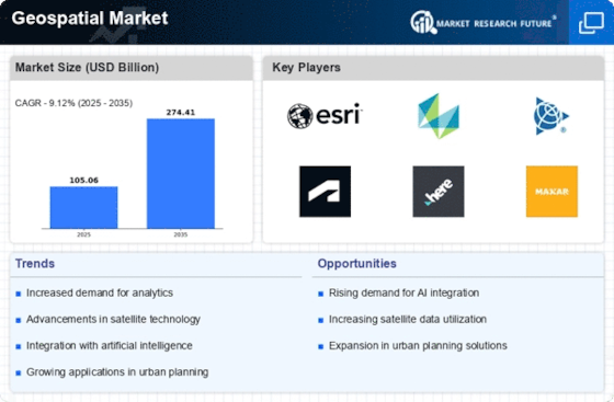
The geospatial market is set to reach US$ 211.58 BN by 2030, at a 12.70% CAGR between years 2022-2030. Right now, the geospatial market is changing a lot because of new technology. This demand for information about where things are growing fast in many industries too. In the geospatial sector, several main things help it to grow and change. These factors are important in shaping its market situation as well. One main reason for the growth of geospatial market is the fast rise and use of satellite technology. With the start of high-quality satellites for pictures, our ability to get clear and true location information has much better.
This has caused more people to want pictures from space and location data in areas like city-building, farming food, handling disasters and guarding against threats. Another important thing that affects how markets work is the growth of things like smart devices and connected items on the Internet. When geospatial data is combined with IoT, it lets us watch and follow assets in real time. This helps make better choices more quickly. Businesses like logistics, transport and smart cities use maps to find the best routes. They also make their operations more efficient by saving time. The self-driving car industry is also seeing a big increase in demand for location data.
Accurate maps and location services are important for self-driving cars to work well. As more and more self-driving cars are on the road, we need better maps for navigation, spotting obstacles and finding routes. Also, the growing attention on keeping our environment healthy has pushed people to use geospatial technology when watching over and protecting nature. Governments and groups are using location-based information to look at natural resources, keep an eye on cutting down trees, check effects of climate change, and make plans for land use in a good way. Also, these factors are being helped by the increase of cloud computing and geospatial analysis. Cloud geo services let businesses and governments store, handle lots of map data cheaply. This is good because it's easy to use them for any size job. This change towards using the cloud makes it easier to work together, share data and make decisions in many areas.
Report Attribute/Metric | Details |
---|---|
Segment Outlook | Type, technology , and End-Users |
Geospatial Market Size was valued at USD 96.26 Billion in 2023. The Geospatial market industry is projected to grow from USD 105.06 Billion in 2024 to USD 211.54 Billion by 2032, exhibiting a compound annual growth rate (CAGR) of 9.1% during the forecast period (2024 - 2032). Geospatial, growing demand for location-based services and rising need for spatial data analysis in various industries are the key market drivers boosting the growth of the Geospatial market.
As per Analyst at MRFR, “the rising adoption of Geographic Information System (GIS) technology across sectors such as urban planning, transportation, agriculture, natural resource management, and disaster management. GIS enables organizations to capture, store, analyze, and visualize spatial data, empowering them to make informed decisions, optimize operations, and enhance efficiency.”
FIGURE 1: GEOSPATIAL MARKET SIZE 2018-2032 (USD BILLION)
Source: Secondary Research, Primary Research, MRFR Database, and Analyst Review
The convergence of AI and IoT technologies has unlocked unprecedented capabilities in geospatial analytics by enabling the processing and analysis of vast amounts of spatial data in real-time. AI algorithms, such as machine learning and deep learning, can extract valuable patterns and trends from geospatial data streams collected by IoT devices, sensors, satellites, and other sources. This synergy empowers organizations to gain deeper insights into various phenomena, ranging from supply chain logistics and asset tracking to environmental monitoring and disaster management.
One of the key advantages of integrating AI with IoT in geospatial analytics is enhanced predictive capabilities. By leveraging historical data and real-time sensor inputs, AI algorithms can forecast future events and trends with greater accuracy. For example, in the transportation sector, AI-powered geospatial analytics can predict traffic congestion patterns based on historical traffic data, weather conditions, and ongoing events, enabling authorities to optimize traffic flow and plan infrastructure investments accordingly.
Furthermore, the combination of AI and IoT in geospatial analytics enables proactive decision-making. Through continuous monitoring and analysis of spatial data, organizations can detect anomalies, identify emerging risks, and take preemptive actions to mitigate potential disruptions. For instance, in the energy sector, AI-driven geospatial analytics can monitor the condition of critical infrastructure, such as pipelines and power grids, and alert operators to potential equipment failures or safety hazards before they escalate into costly incidents.
Another compelling application of AI-enabled geospatial analytics is in environmental monitoring and conservation efforts. By leveraging IoT sensors deployed in remote locations, AI algorithms can analyze geospatial data to track changes in biodiversity, monitor deforestation rates, and assess the impact of climate change on ecosystems. This information enables policymakers, conservationists, and researchers to formulate evidence-based strategies for protecting endangered species, preserving natural habitats, and mitigating environmental degradation.
Moreover, the integration of AI and IoT in geospatial analytics is driving innovation in smart city development. By leveraging real-time data from IoT sensors embedded in urban infrastructure, such as smart streetlights, traffic cameras, and environmental sensors, AI-powered geospatial analytics can optimize resource allocation, improve public safety, and enhance quality of life for residents. For example, AI algorithms can analyze traffic flow patterns to optimize signal timing at intersections, reduce congestion, and minimize travel times for commuters.
Based on Type, the Geospatial Market segmentation includes surface analytics, network analytics, geovisualization and others. The surface analytics held the majority share in 2023, contributing around ~53% to the market revenue. Surface analytics in the geospatial market involves the analysis of data pertaining to the Earth's surface. This includes various features such as terrain, land cover, vegetation, and topography. Surface analytics utilize geospatial data to understand patterns, trends, and changes occurring on the Earth's surface. It involves the use of advanced technologies such as Geographic Information Systems (GIS), remote sensing, and satellite imagery to collect, process, and analyze surface data.One of the key applications of surface analytics is in environmental monitoring and management. It enables scientists and researchers to assess changes in land cover, monitor deforestation, track urban sprawl, and analyze the impact of natural disasters such as floods and wildfires. Surface analytics also play a crucial role in land use planning, agriculture, forestry, and infrastructure development. By analyzing surface data, stakeholders can make informed decisions regarding resource management, conservation efforts, and sustainable development.
FIGURE 2: GEOSPATIAL MARKET, BY TYPE, 2023 VS 2032 (USD MILLION)
Source: Secondary Research, Primary Research, MRFR Database, and Analyst Review
Based on the Technology, the Geospatial Market segmentation is Remote Sensing, GPS, GIS and Others. GIS dominated the market in 2023. GIS integrates hardware, software, and data for capturing, managing, analyzing, and displaying geographically referenced information. It enables users to visualize, interpret, and understand spatial patterns and relationships for decision-making and problem-solving. GIS technology incorporates various data types, including maps, satellite imagery, aerial photographs, GPS data, and tabular data, to create layers of information that can be analyzed and manipulated spatially. Common GIS applications span a wide range of industries, including urban planning, natural resource management, environmental monitoring, transportation, public health, real estate, and telecommunications. GIS software packages like ArcGIS, QGIS, and MapInfo offer powerful tools for spatial analysis, modeling, and visualization, making them essential for professionals in diverse fields
Based on end-user, the Geospatial Market segmentation includes real estate & construction, automotive, utility & communication, government, defense & intelligence, natural resources and others. The automotive industry owners held the majority share in 2023. In the automotive industry, geospatial technology is integral to various applications such as navigation systems, autonomous driving, fleet management, and location-based services. GPS (Global Positioning System) is a fundamental component of modern vehicle navigation systems, providing real-time location data and routing information to drivers. Additionally, geospatial analytics help automotive companies optimize logistics and supply chain operations by analyzing traffic patterns, vehicle movements, and transportation routes. With the emergence of autonomous vehicles, precise geospatial data is essential for mapping and localization, enabling safe and efficient navigation in diverse environments.
By Region, the study provides market insights into North America, Europe, Asia-Pacific, and the Rest of the World. The North America Geospatial market accounted for ~37% in 2023. The North American geospatial market stands at the forefront of innovation and adoption, driven by technological advancements and the region's robust infrastructure. With an emphasis on precision mapping, location-based services, and geospatial analytics, the market has witnessed significant growth in recent years. The United States and Canada emerge as key players, leveraging their technological prowess and expansive geographic landscapes to fuel market expansion.
In the United States, the geospatial market is propelled by government initiatives, private sector investments, and a burgeoning startup ecosystem. Government agencies, including the National Geospatial-Intelligence Agency (NGA) and the United States Geological Survey (USGS), play a pivotal role in driving innovation and fostering collaboration within the geospatial community. The commercial sector, encompassing giants like Google, Esri, and Trimble, continuously pushes the boundaries of geospatial technologies, offering diverse solutions ranging from mapping and navigation to spatial analytics and remote sensing. Moreover, the integration of geospatial data with emerging technologies such as artificial intelligence (AI), Internet of Things (IoT), and blockchain augments the market's growth trajectory, unlocking new opportunities across industries like agriculture, urban planning, and disaster management.
FIGURE 3: GEOSPATIAL MARKET SIZE BY REGION 2023 VS 2032
Source: Secondary Research, Primary Research, MRFR Database, and Analyst Review
Further, the major countries studied in the market report are the U.S., Canada, Germany, France, the UK, Italy, Spain, China, Japan, India, Australia, South Korea, and Brazil.
Europe market accounts for the second-largest market share. The geospatial market in Europe is experiencing significant growth, driven by technological advancements, increasing adoption of location-based services, and government initiatives. The market is witnessing a surge in demand for geospatial solutions across various industries, including agriculture, construction, transportation, and utilities. One of the key drivers of this growth is the rising need for accurate and real-time geospatial data for efficient decision-making and resource management. In addition, the proliferation of smartphones and other connected devices equipped with GPS capabilities is fueling the demand for location-based services, further propelling the growth of the geospatial market in Europe
The Asia Pacific Geospatial Market is expected to grow at the fastest CAGR between 2024 and 2032. The Asia Pacific region is experiencing rapid growth and adoption of geospatial technologies across various sectors, fueled by increasing urbanization, infrastructure development, and government initiatives. The market analysis reveals a diverse landscape, with key players such as Esri, Hexagon AB, and Trimble dominating the market alongside regional players like PASCO Corporation and SuperMap Software Co., Ltd. The market size is projected to expand significantly due to rising demand for location-based services, smart city development, and precision agriculture
With a strong presence across different verticals and geographies, the Geospatial market is highly competitive and dominated by established, pure-play vendors. Over 30 vendors cater to this market, and they continually innovate their solutions to meet the evolving needs of businesses by adopting new technologies. These vendors have a robust geographic footprint and partner ecosystem to cater to diverse customer segments. The Geospatial market is highly competitive, with many vendors offering similar products and services.
The major players in the market include Hexagon AB, Maxar Technologies, Esri, Trimble Inc., MDA Corporation. Maxar focused on diversifying its product offerings by expanding into emerging geospatial markets such as autonomous vehicles and augmented reality applications. Leveraging its expertise in satellite imaging, Maxar aims to develop innovative solutions for precision agriculture and environmental monitoring, enhancing its revenue streams. Collaborating with government agencies and private sector partners will be crucial to secure contracts for large-scale projects like infrastructure development and disaster management.
The Geospatial Market is consolidated, increasing competition, acquisitions, mergers, and other strategic market developments and decisions to improve operational effectiveness.
In February 2023, U.S. Army has extended its contract with Maxar Technologies to provide 3D geospatial data used to create immersive digital environments. Maxar was awarded Phase 3b of the U.S. Army’s One World Terrain (OWT) contract originally awarded in 2019 to Vricon, a company Maxar acquired in 2020. Vricon uses data from Maxar’s imaging satellites to make 3D mapping products.
In September 2023, Trimble and Kyivstar Partner to Provide GNSS Correction Services for Agriculture, Construction and Geospatial Applications in Ukraine. It will install a new Continuously Operating Reference Station (CORS) network to provide Global Navigation Satellite System (GNSS) correction services across the country. Available to users as an annual subscription service, the new network will be built using Trimble's hardware and software positioning technology, which provides customers with easy and reliable high-accuracy real time or post-processed GNSS corrections data for agriculture, construction, geospatial, Internet of Things (IoT) and other commercial operations.
© 2024 Market Research Future ® (Part of WantStats Reasearch And Media Pvt. Ltd.)