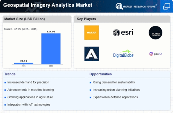
Top Industry Leaders in the Geospatial Imagery Analytics Market

Competitive Landscape of the Geospatial Imagery Analytics Market:
The geospatial imagery analytics market is experiencing a surge, fueled by the convergence of advanced technologies like artificial intelligence (AI), machine learning (ML), and remote sensing. Navigating this competitive landscape requires a keen understanding of the key players, their strategies, and the factors influencing market share.
Key Players:
- Citrix Systems Inc.
- Toshiba Corporation
- DigitalGlobe Google
- Fugro NV
- Hexagon AB
- Environmental Systems Research Institute
- UrtheCast Corporation
- KeyW Corporation
- Satellite Imaging Corporation
- Planet Labs
- Harris Corporation
- Orbital Insight
- GeoSpoc
- TomTom
- RMSI
- Geospin
- Esri
- Alteryx
- Mapidea
- Geocento
- Oracle Corporation
- Maxar Technologies
- ZillionInfo
- Sparkgeo
- Ursa Space Systems
- Capella Space
Strategies for Differentiation and Growth:
- Specialization:Players are focusing on specific industry verticals, like agriculture or defense, to offer tailored solutions and cater to niche needs.
- Technology Integration:Integrating AI and ML algorithms into existing platforms is crucial for advanced image recognition, object detection, and predictive analytics.
- Cloud-Based Solutions:The shift to cloud platforms enables scalability, accessibility, and faster data processing, catering to the growing demand for real-time insights.
- Partnerships and Acquisitions:Collaborating with startups, universities, and data providers expands capabilities and accelerates innovation. Strategic acquisitions strengthen market presence and diversify offerings.
- Focus on User Experience:Intuitive and user-friendly interfaces are essential for wider adoption, particularly among non-technical users.
Factors Influencing Market Share Analysis:
- Product Portfolio Breadth and Depth:Offering a comprehensive range of solutions across different applications and verticals is key.
- Technological Innovation:Continuous investment in R&D and integration of cutting-edge technologies like deep learning and computer vision is crucial for staying ahead of the curve.
- Customer Service and Support:Providing robust technical support and training ensures user satisfaction and retention.
- Pricing and Market Penetration Strategies:Competitive pricing and flexible licensing models attract new customers, while strong marketing and sales strategies drive market awareness and adoption.
- Geographic Reach and Expansion:Global presence and ability to cater to diverse regional needs are crucial for market share growth.
Emerging Players and Disruptive Trends:
- Startups:Agile startups are entering the market with innovative AI-powered solutions for specific applications, like crop health monitoring or urban planning.
- Open-Source Platforms:Open-source software like GDAL and QGIS are gaining traction, offering users greater flexibility and customization options.
- Drone Technology:The increasing adoption of drones for data acquisition is creating opportunities for near-real-time monitoring and analytics at a local scale.
- Focus on Sustainability:Solutions addressing environmental challenges like deforestation and climate change are gaining traction, attracting investors and driving market growth.
Current Investment Trends:
- Venture Capital:VC firms are increasingly investing in promising geospatial startups, particularly those leveraging AI and ML for advanced analytics.
- Private Equity:PE firms are eyeing established players with strong growth potential and the ability to consolidate the market through strategic acquisitions.
- Government Funding:Government initiatives and grants are supporting research and development in geospatial technologies, particularly for applications in public safety, disaster management, and national security.
Latest Company Updates:
Oct 26, 2023, BlackBridge, a provider of geospatial intelligence solutions, acquired Stratageo, a developer of AI-powered geospatial analytics tools, to strengthen its AI capabilities.
Nov 15, 2023, Maxar Technologies, a leading satellite imagery provider, announced a partnership with Microsoft Azure to offer cloud-based geospatial analytics solutions for environmental monitoring.
Dec 05, 2023, Esri, a GIS software giant, launched its ArcGIS Online Spatial Analyst extension, providing advanced geospatial analytics tools for users of its cloud platform.


