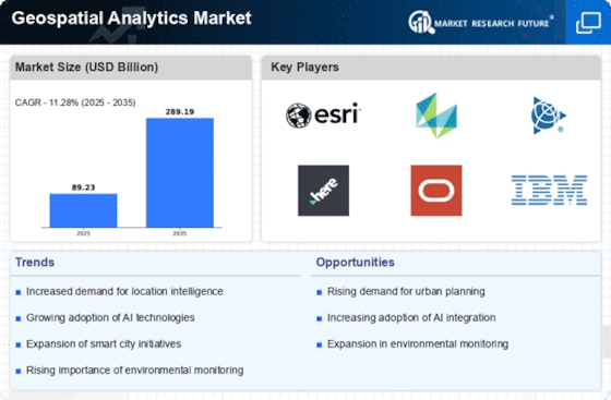
Top Industry Leaders in the Geospatial Analytics Market

Competitive Landscape of Geospatial Analytics Market
The geospatial analytics market, fueled by the convergence of location intelligence, advanced analytics, and cloud technologies, is experiencing robust growth. As organizations increasingly seek actionable insights from their spatial data, the competitive landscape is bustling with established players, emerging startups, and strategic partnerships. Navigating this dynamic scene requires an understanding of the key players, their strategies, and the factors influencing market share.
Market Leaders and Established Players:
- IBM Corporation (U.S.)
- Trimble Navigation Ltd. (U.S.)
- ESRI (U.S.)
- General Electric (U.S.)
- MDA (Canada)
- Fugro N.V. (Netherlands)
- RMSI (India)
- Alteryx (U.S.)
- Hexagon AB (Sweden)
- Harris Corporation (U.S.)
- DigitalGlobe, Inc. (U.S.)
- Bentley Systems, Inc. (U.S.)
- Transerve technologies (India)
Strategies for Growth:
- Product Innovation: Players like Esri and Google are constantly innovating, incorporating AI, machine learning, and deep learning into their platforms to unlock new insights and capabilities.
- Cloud Adoption: Migrating to cloud-based solutions is accelerating, with players like Mapbox and Maxar offering scalable and accessible platforms.
- Partnerships and Acquisitions: Strategic collaborations and acquisitions are common, as companies seek to expand their offerings and expertise. Examples include Esri's partnership with Microsoft Azure and Maxar's acquisition of DigitalGlobe.
- Vertical Specialization: Players are tailoring their solutions to specific industry needs, developing solutions for precision agriculture, smart cities, and insurance risk assessment.
Factors Influencing Market Share Analysis:
- Geographic Reach: Global players like Esri and Google have a wider reach, while regional players like SuperMap and SinoGeospatial cater to specific markets.
- Technology Breadth and Depth: Some players offer comprehensive platforms, while others excel in specific areas like satellite imagery or AI-powered analytics.
- Pricing and Subscription Models: Flexible pricing models and attractive subscription options are key differentiators, with open-source options like OpenGeoSpatial Foundation also gaining traction.
- Customer Focus and Support: Strong customer service, technical support, and training programs are crucial for building long-term relationships.
Emerging Players and Disruptors:
- Startups: Companies like Planet Labs and Hyperplane are pushing boundaries with innovative satellite constellations and AI-powered location-based services.
- Open-source Initiatives: Open-source platforms like OpenStreetMap and GDAL are fostering collaboration and democratizing access to geospatial data and tools.
- Industry-Specific Players: Companies like Aerionics (aviation) and Descartes Systems (logistics) are developing niche solutions tailored to specific industry challenges.
Current Investment Trends:
- Venture Capital: Investment in geospatial startups is on the rise, with companies like Planet Labs and BlackSky attracting significant funding.
- Private Equity: Established players are also attracting private equity investments, driven by the market's growth potential.
- Focus on AI and ML: Investors are increasingly interested in companies leveraging AI and machine learning to unlock advanced geospatial insights.
- Cloud Migration: Investments in cloud-based geospatial platforms and services are expected to continue growing.
Latest Company Updates:
SkyFi, a top provider of Earth observation data, is pleased to announce that the simultaneous release of two revolutionary products—open data and SkyFi Insights—will mark a significant advancement in data easification in 2023.
The third technological support centre opened by CyberTech Systems and Software in Kolkata, India, in 2023. The facility is committed to delivering unrivalled support for Esri's GIS technology and products, with an emphasis on enhancing CyberTech's ability to deliver world-class support for the ArcGIS product line.
Aerial Vantage announces the launch of Accelerate, its main product, in 2022. By gathering, processing, managing, and translating data from airborne sensors, this cutting-edge geospatial intelligence platform improves stakeholders' capacity to utilise aerial imagery.


