• Cat-intel
  • MedIntelliX
  • Resources
  • About Us
  • Request Free Sample ×

    Kindly complete the form below to receive a free sample of this Report

    Leading companies partner with us for data-driven Insights

    clients tt-cursor
    Hero Background

    Geographic Information System Gis Software Market

    ID: MRFR/ICT/24797-HCR
    100 Pages
    Ankit Gupta
    October 2025

    Geographic Information System Gis Software Market Research Report: By Deployment Model (Cloud-based, On-premises), By Application (Urban Planning, Natural Resource Management, Transportation Planning, Utilities Management, Disaster Management), By Technology (2D GIS, 3D GIS, 4D GIS, Mobile GIS, Web GIS), By Industry Vertical (Government, Utilities, Transportation, Defense, Telecommunications) and By Regional (North America, Europe, South America, Asia Pacific, Middle East and Africa) - Forecast to 2035.

    Share:
    Download PDF ×

    We do not share your information with anyone. However, we may send you emails based on your report interest from time to time. You may contact us at any time to opt-out.

    Geographic Information System Gis Software Market
 Infographic
    Purchase Options

    Geographic Information System Gis Software Market Summary

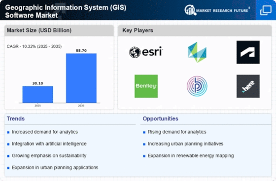
    As per MRFR analysis, the Geographic Information System Gis Software Market was estimated at 30.1 USD Billion in 2024. The GIS software industry is projected to grow from 33.21 USD Billion in 2025 to 88.7 USD Billion by 2035, exhibiting a compound annual growth rate (CAGR) of 10.32 during the forecast period 2025 - 2035.

    Key Market Trends & Highlights

    The Geographic Information System (GIS) software market is experiencing robust growth driven by technological advancements and increasing demand for real-time data.

    • The integration of AI and machine learning technologies is transforming GIS capabilities, enhancing data analysis and visualization.
    • Cloud-based GIS solutions dominate the market, while on-premises systems are witnessing rapid growth due to specific organizational needs.
    • North America remains the largest market for GIS software, whereas the Asia-Pacific region is emerging as the fastest-growing area, driven by urbanization.
    • Key market drivers include the increasing adoption of smart city initiatives and the growing need for location-based services, which are propelling GIS software demand.

    Market Size & Forecast

    2024 Market Size 30.1 (USD Billion)
    2035 Market Size 88.7 (USD Billion)
    CAGR (2025 - 2035) 10.32%

    Major Players

    Esri (US), Hexagon (SE), Autodesk (US), Bentley Systems (US), Pitney Bowes (US), HERE Technologies (NL), Oracle (US), QGIS (US), MapInfo (US)

    Geographic Information System Gis Software Market Trends

    The Geographic Information System Gis Software Market is currently experiencing a dynamic evolution, driven by advancements in technology and increasing demand for spatial data analysis. Organizations across various sectors are recognizing the value of geographic information systems in enhancing decision-making processes, optimizing resource management, and improving operational efficiency. As a result, the market is witnessing a surge in the adoption of GIS software solutions, which are becoming integral to urban planning, environmental monitoring, and disaster management. Furthermore, the integration of artificial intelligence and machine learning into GIS applications is enhancing analytical capabilities, allowing for more sophisticated data interpretation and visualization. In addition to technological advancements, the Geographic Information System Gis Software Market is influenced by growing awareness of the importance of location-based services. Businesses are increasingly leveraging GIS tools to gain insights into customer behavior, market trends, and competitive landscapes. This trend is further supported by the proliferation of mobile devices and the Internet of Things, which facilitate real-time data collection and analysis. As the market continues to expand, it is likely that new players will emerge, offering innovative solutions that cater to the evolving needs of users. Overall, the Geographic Information System Gis Software Market appears poised for sustained growth, driven by a combination of technological innovation and increasing demand for spatial intelligence.

    Integration of AI and Machine Learning

    The incorporation of artificial intelligence and machine learning technologies into Geographic Information System Gis Software is transforming data analysis capabilities. This trend enables users to derive deeper insights from spatial data, facilitating predictive analytics and enhancing decision-making processes.

    Rise of Cloud-Based Solutions

    Cloud computing is becoming increasingly prevalent within the Geographic Information System Gis Software Market. This shift allows for greater accessibility, scalability, and collaboration among users, as organizations can store and analyze vast amounts of geographic data without the constraints of traditional infrastructure.

    Growing Demand for Real-Time Data

    There is a notable increase in the demand for real-time data within the Geographic Information System Gis Software Market. Organizations are seeking tools that provide immediate insights into geographic information, which is essential for timely decision-making in various applications, including emergency response and urban planning.

    The increasing integration of Geographic Information System technology across various sectors indicates a transformative shift in data analysis and decision-making processes.

    U.S. Geological Survey

    Geographic Information System Gis Software Market Drivers

    Expansion of Environmental Monitoring

    The expansion of environmental monitoring efforts significantly influences the Geographic Information System Gis Software Market. With growing concerns about climate change and environmental degradation, organizations are increasingly utilizing GIS software to monitor natural resources, track pollution levels, and assess the impact of human activities on ecosystems. Data indicates that the environmental monitoring sector is experiencing rapid growth, with investments in GIS technology expected to rise. This software enables precise mapping and analysis of environmental data, facilitating informed decision-making for conservation efforts. As regulatory frameworks become more stringent, the demand for GIS solutions that support compliance and reporting is likely to increase, further driving the Geographic Information System Gis Software Market.

    Advancements in Spatial Data Analytics

    Advancements in spatial data analytics are reshaping the Geographic Information System Gis Software Market. The integration of sophisticated analytical tools within GIS software allows users to derive actionable insights from complex datasets. This capability is particularly valuable in sectors such as transportation, agriculture, and public health, where spatial analysis can lead to improved outcomes. Market data suggests that the demand for advanced analytics features is on the rise, as organizations seek to enhance operational efficiency and strategic planning. By harnessing the power of spatial data, businesses can optimize resource allocation, improve service delivery, and make data-driven decisions. This trend underscores the importance of innovative GIS solutions in the evolving landscape of the Geographic Information System Gis Software Market.

    Growing Need for Location-Based Services

    The growing need for location-based services is a critical driver for the Geographic Information System Gis Software Market. As businesses and consumers increasingly rely on location data for various applications, the demand for GIS software that can provide accurate and timely information is surging. Industries such as retail, logistics, and tourism are leveraging location-based services to enhance customer experiences and streamline operations. Market analysis indicates that the location-based services sector is expanding rapidly, with significant investments being made in GIS technologies. This trend is likely to continue as organizations recognize the value of location intelligence in gaining competitive advantages. Consequently, the Geographic Information System Gis Software Market is poised for substantial growth as it caters to this burgeoning demand.

    Integration of IoT with GIS Technologies

    The integration of Internet of Things (IoT) with GIS technologies is emerging as a transformative driver for the Geographic Information System Gis Software Market. As IoT devices proliferate, the ability to collect and analyze spatial data in real-time becomes increasingly feasible. This integration allows for enhanced monitoring and management of assets across various sectors, including agriculture, transportation, and urban planning. Data suggests that the convergence of IoT and GIS is expected to create new opportunities for innovation and efficiency. Organizations are likely to invest in GIS solutions that can seamlessly incorporate IoT data, enabling smarter decision-making and improved operational performance. This trend highlights the potential for growth within the Geographic Information System Gis Software Market as it adapts to the evolving technological landscape.

    Increasing Adoption of Smart City Initiatives

    The increasing adoption of smart city initiatives is a pivotal driver for the Geographic Information System Gis Software Market. As urban areas strive to enhance efficiency and sustainability, GIS software becomes essential for urban planning, resource management, and infrastructure development. According to recent data, investments in smart city projects are projected to reach substantial figures, indicating a robust demand for GIS solutions. These initiatives often require advanced spatial analysis and real-time data integration, which GIS software adeptly provides. Consequently, municipalities and governments are increasingly leveraging GIS technology to optimize services, improve public safety, and enhance citizen engagement. This trend not only propels the market forward but also fosters innovation within the Geographic Information System Gis Software Market.

    Market Segment Insights

    By Deployment Model: Cloud-based (Largest) vs. On-premises (Fastest-Growing)

    In the Geographic Information System (GIS) Software Market, the deployment model segment has shown a clear preference for cloud-based solutions, dominating the market landscape. This segment benefits from the scalability and accessibility of cloud services, allowing organizations to leverage GIS functionalities without heavy investments in infrastructure. On-premises solutions, while historically significant, have seen a shift in adoption as enterprises move towards flexible and cost-effective cloud offerings.

    Deployment Model: Cloud-based (Dominant) vs. On-premises (Emerging)

    Cloud-based GIS software has emerged as the dominant deployment model due to its ability to offer real-time data processing, collaboration, and integration with other cloud services. Its widespread adoption reflects a shift towards more agile business operations. Conversely, on-premises GIS solutions, although identified as an emerging model, cater to organizations with stringent data security and compliance needs, preferring to maintain full control over their infrastructure. This traditional model is evolving, with hybrid approaches gaining traction, indicating a potential renaissance in on-premises deployments.

    By Application: Urban Planning (Largest) vs. Disaster Management (Fastest-Growing)

    In the Geographic Information System (GIS) Software Market, the application segment is large and varied, with urban planning holding the largest market share. This segment utilizes GIS software for enhanced decision-making, urban infrastructure development, and resource management. On the other hand, disaster management, while smaller currently, is emerging rapidly due to increasing awareness and investments in emergency response and planning systems. As a result, it represents a vital sector with exacting requirements for timely and efficient responses.

    Urban Planning: Dominant vs. Disaster Management: Emerging

    Urban Planning is a dominant application within the GIS software market, ensuring the effective design and management of urban environments through advanced analytics and spatial data visualization. Urban planners rely on GIS to assess population growth, land use, and infrastructure needs, facilitating sustainable development. In contrast, Disaster Management is emerging as a key area driven by environmental changes and heightened global risks. GIS technology enables comprehensive risk analysis, preparedness planning, and real-time data integration during disasters, making it indispensable for government agencies and organizations focused on safety and resilience.

    By Technology: 2D GIS (Largest) vs. 3D GIS (Fastest-Growing)

    In the Geographic Information System GIS Software Market, the 2D GIS segment holds the largest share, making it the cornerstone of GIS applications. This traditional technology is widely used for mapping, urban planning, and infrastructure management, providing essential tools for analyzing spatial data. Conversely, the 3D GIS segment is rapidly gaining traction, driven by advancements in visualization technology and the increasing demand for three-dimensional representations in various sectors, including construction and environmental monitoring.

    Technology: 2D GIS (Dominant) vs. 3D GIS (Emerging)

    2D GIS remains the dominant player in the GIS market, offering robust solutions for analyzing geographical data in two-dimensional formats. Its widespread use in governmental agencies and urban planning signifies its foundational role in spatial analysis. Meanwhile, 3D GIS represents an emerging segment characterized by its ability to provide dynamic and realistic models of geographical features. As industries seek enhanced visualization capabilities, 3D GIS is poised for significant growth, driven by applications in fields such as virtual reality, architecture, and urban development.

    By Industry Vertical: Government (Largest) vs. Utilities (Fastest-Growing)

    In the Geographic Information System (GIS) Software Market, the Government sector holds the largest share, driven by increasing investments in public infrastructure and urban planning projects. This sector is utilizing GIS technology extensively for land management, environmental monitoring, and disaster response. Meanwhile, the Utilities sector is rapidly expanding, with organizations adopting GIS solutions for optimizing resource allocation, maintenance, and asset management, reflecting growing awareness of the technology's benefits for operational efficiency. The growth trends within these industry verticals highlight a collective shift towards data-driven strategies. Government agencies are increasingly leveraging GIS for smart city initiatives, while utilities are transitioning to embrace sustainability goals. This is further amplified by advancements in technology, with cloud-based GIS solutions driving accessibility and integration across both sectors, fostering continuous growth and innovation in their respective practices.

    Government (Dominant) vs. Telecommunications (Emerging)

    The Government sector represents a dominant force in the GIS software market, driven by the need for enhanced decision-making and strategic planning capabilities. This segment leverages GIS for various applications, including resource management, urban development, and emergency response strategies. On the other hand, the Telecommunications industry is an emerging player, increasingly recognizing the value of GIS in network planning and optimization. Telecommunications companies are employing GIS solutions to analyze geographical data, aiding in site selection for new infrastructure and improving service quality. Both sectors exhibit strong interdependencies, with government regulations influencing telecommunications expansions, while advanced GIS analytics support governments in managing public services effectively.

    Get more detailed insights about Geographic Information System Gis Software Market

    Regional Insights

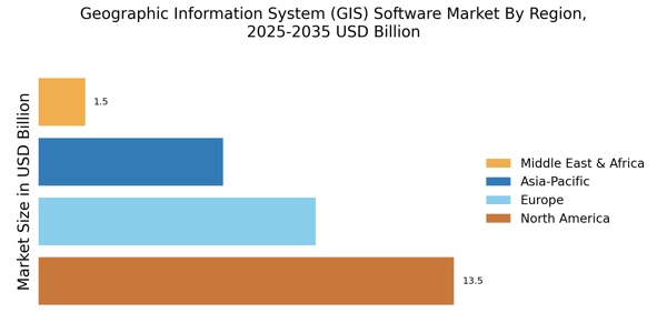
    The regional segment of the Geographic Information System (GIS) Software Market holds significant importance in understanding market dynamics and growth opportunities. North America, Europe, APAC, South America, and MEA are key regions in the GIS software market. North America is expected to dominate the market in 2023, with a market size of USD 9.14 billion, primarily driven by the presence of established vendors and high adoption rates in sectors such as government, defense, and utilities.

    Europe follows closely with a market size of USD 6.38 billion, owing to the increasing use of GIS in urban planning, transportation, and environmental management.APAC is projected to witness substantial growth, reaching a market size of USD 5.72 billion by 2023, fueled by rapid urbanization, infrastructure development, and government initiatives in countries like China and India. South America and MEA are expected to show steady growth, with market sizes of USD 1.87 billion and USD 1.63 billion, respectively, in 2024. The growth in these regions is attributed to increasing investments in infrastructure, natural resource management, and disaster risk reduction.

    Figure 3: Geographic Information System Gis Software Market, By Regional, 2023 & 2032

    Geographic Information System Gis Software Market Regional Insights

    Source: Primary Research, Secondary Research, Market Research Future Database and Analyst Review

    Key Players and Competitive Insights

    Leading companies operating in the Geographic Information System Gis Software Market industry are increasingly looking for ways to differentiate themselves from their competitors. Therefore, many companies are trying to occupy the fastest-growing market segments, as well as develop new services and open offices in new geographies. Competitive advantages are also being built by establishing partnerships and concluding deals in the market of Geographic Information System Gis Software Market. In addition, developers invest heavily in research and development to create cutting-edge technology.
    As the specialization is highly competitive, Geographic Information System Gis Software Market development has to focus on technological advancements and enhanced user experience. Leading companies use cutting-edge technology when developing Geographic Information Systems Gis Software Market projects. Esri is a leading developer of a wide range of GIS software products for numerous industries. ArcGIS program is a flagship product of Esri and it is used in many countries of the world for mapping, data analysis and decision-making. The company heavily invests in research and development and has a well-developed system of customer support.

    It has a strong position in North America and is increasingly investing in emerging markets.

    Hexagon AB offers a range of programs targeted for the Geographic Information System Gis Software Market. Those include, among others, ERDAS IMAGINE, GeoMedia, and Intergraph G/Technology, as well as other products tailored for specific needs of sectors such as utilities and transportation or public safety. Hexagon has a strong position in the utility, transportation and public safety sectors and is particularly active in the North American market. The strength of the company results from developing products aimed specifically at particular types of partners, as well as strong relationships with customers.
    Key Companies in the Geographic Information System Gis Software Market market include

    Industry Developments

    • Q2 2024: Esri and Microsoft Expand Partnership to Advance Cloud-Based Geospatial Analytics Esri announced an expanded partnership with Microsoft to integrate Esri’s ArcGIS platform with Microsoft’s Azure cloud services, aiming to deliver advanced geospatial analytics and mapping capabilities to enterprise customers.
    • Q2 2024: Trimble Launches New Version of Trimble SiteVision for Enhanced Outdoor Augmented Reality GIS Applications Trimble introduced an updated version of its SiteVision system, offering improved outdoor augmented reality capabilities for GIS professionals, including real-time visualization of geospatial data in the field.
    • Q2 2024: Autodesk Announces Acquisition of Innovyze to Strengthen GIS and Water Infrastructure Solutions Autodesk completed the acquisition of Innovyze, a provider of water infrastructure modeling software, to enhance its GIS and infrastructure design offerings for municipal and utility customers.
    • Q2 2024: Bentley Systems and Topcon Positioning Group Announce Strategic Partnership for Integrated GIS and Construction Workflows Bentley Systems and Topcon Positioning Group formed a strategic partnership to integrate GIS data with construction management workflows, aiming to improve project delivery and asset management.
    • Q3 2024: Hexagon Launches Next-Generation M.App Enterprise for Real-Time Geospatial Intelligence Hexagon AB released the latest version of its M.App Enterprise platform, featuring enhanced real-time geospatial intelligence tools for enterprise and government users.
    • Q3 2024: Esri Unveils ArcGIS Urban 2025 with AI-Driven Planning Tools Esri launched ArcGIS Urban 2025, introducing new AI-powered features for city planners to simulate and analyze urban development scenarios using geospatial data.
    • Q3 2024: HERE Technologies secures $100 million investment to expand geospatial platform HERE Technologies announced a $100 million investment round to accelerate the development of its geospatial data platform and expand its global reach.
    • Q4 2024: Ordnance Survey partners with Google Cloud to deliver next-generation mapping services Ordnance Survey, the UK’s national mapping agency, entered a partnership with Google Cloud to modernize its mapping services and provide advanced GIS solutions to public and private sector clients.
    • Q4 2024: Trimble Acquires Cityworks to Expand GIS-Based Asset Management Solutions Trimble acquired Cityworks, a provider of GIS-centric public asset management software, to strengthen its portfolio of solutions for local governments and utilities.
    • Q1 2025: Esri Appoints New Chief Technology Officer to Lead GIS Innovation Esri announced the appointment of a new Chief Technology Officer, tasked with driving innovation in GIS software and cloud-based geospatial services.
    • Q1 2025: Mapbox Raises $50 Million in Series D Funding to Expand AI Mapping Capabilities Mapbox secured $50 million in Series D funding to accelerate the development of its AI-powered mapping and geospatial analytics tools.
    • Q2 2025: Bentley Systems Opens New R&D Facility Focused on Geospatial and Digital Twin Technologies Bentley Systems inaugurated a new research and development center dedicated to advancing geospatial software and digital twin solutions for infrastructure projects.

    Future Outlook

    Geographic Information System Gis Software Market Future Outlook

    The Geographic Information System GIS Software Market is projected to grow at a 10.32% CAGR from 2024 to 2035, driven by advancements in data analytics, urbanization, and environmental monitoring.

    New opportunities lie in:

    • Integration of AI-driven analytics for enhanced decision-making
    • Development of mobile GIS applications for field data collection
    • Expansion into emerging markets with tailored GIS solutions

    By 2035, the market is expected to be robust, reflecting substantial growth and innovation.

    Market Segmentation

    Geographic Information System Gis Software Market Technology Outlook

    • 2D GIS
    • 3D GIS
    • 4D GIS
    • Mobile GIS
    • Web GIS

    Geographic Information System Gis Software Market Application Outlook

    • Urban Planning
    • Natural Resource Management
    • Transportation Planning
    • Utilities Management
    • Disaster Management

    Geographic Information System Gis Software Market Deployment Model Outlook

    • Cloud-based
    • On-premises

    Geographic Information System Gis Software Market Industry Vertical Outlook

    • Government
    • Utilities
    • Transportation
    • Defense
    • Telecommunications

    Report Scope

    MARKET SIZE 202430.1(USD Billion)
    MARKET SIZE 202533.21(USD Billion)
    MARKET SIZE 203588.7(USD Billion)
    COMPOUND ANNUAL GROWTH RATE (CAGR)10.32% (2024 - 2035)
    REPORT COVERAGERevenue Forecast, Competitive Landscape, Growth Factors, and Trends
    BASE YEAR2024
    Market Forecast Period2025 - 2035
    Historical Data2019 - 2024
    Market Forecast UnitsUSD Billion
    Key Companies ProfiledMarket analysis in progress
    Segments CoveredMarket segmentation analysis in progress
    Key Market OpportunitiesIntegration of artificial intelligence enhances data analysis in the Geographic Information System Gis Software Market.
    Key Market DynamicsRising demand for data visualization tools drives innovation and competition in the Geographic Information System Software market.
    Countries CoveredNorth America, Europe, APAC, South America, MEA

    Leave a Comment

    FAQs

    What is the market size of the Geographic Information System (GIS) Software market?

    The GIS Software market size is expected to reach USD 27.28 billion in 2023 and is projected to grow at a compound annual growth rate (CAGR) of 10.32% from 2025 to 2034, reaching a total market value of USD 80.39 billion by 2034.

    What are the key regions driving the growth of the GIS Software market?

    North America and Europe are the dominant regions in the GIS Software market, accounting for a significant share of the market revenue. Asia-Pacific is expected to witness the highest growth rate during the forecast period due to increasing urbanization, infrastructure development, and government initiatives to adopt GIS technology.

    What are the major applications of GIS Software?

    GIS Software finds applications in various industries, including urban planning, environmental management, transportation, utilities, defense, and agriculture. It is used for tasks such as data visualization, spatial analysis, and decision-making.

    Who are the key competitors in the GIS Software market?

    The major players in the GIS Software market include Esri, Hexagon AB, Trimble Inc., Autodesk, and Bentley Systems. These companies offer a range of GIS software solutions, including desktop, mobile, and cloud-based platforms.

    What are the key trends shaping the GIS Software market?

    The GIS Software market is witnessing several trends, such as the increasing adoption of cloud-based GIS solutions, the integration of artificial intelligence (AI) and machine learning (ML) technologies, and the growing demand for real-time GIS data.

    What are the challenges faced by the GIS Software market?

    The GIS Software market faces challenges related to data security and privacy concerns, the lack of skilled professionals, and the high cost of implementation and maintenance of GIS systems.

    What are the growth opportunities for the GIS Software market?

    The GIS Software market presents growth opportunities in emerging economies, the increasing adoption of GIS technology in new application areas, and the development of innovative GIS software solutions.

    What are the key factors driving the growth of the GIS Software market?

    The growth of the GIS Software market is driven by factors such as the increasing demand for location-based data, the need for improved decision-making, and the growing adoption of GIS technology in various industries.

    What are the key end-user industries for GIS Software?

    The key end-user industries for GIS Software include government agencies, utilities, transportation companies, and environmental organizations.

    What are the key trends that will shape the future of the GIS Software market?

    The key trends that will shape the future of the GIS Software market include the increasing adoption of cloud-based GIS solutions, the integration of artificial intelligence (AI) and machine learning (ML) technologies, and the growing demand for real-time GIS data.

    Download Free Sample

    Kindly complete the form below to receive a free sample of this Report

    Case Study
    Chemicals and Materials

    Compare Licence

    ×
    Features License Type
    Single User Multiuser License Enterprise User
    Price $4,950 $5,950 $7,250
    Maximum User Access Limit 1 User Upto 10 Users Unrestricted Access Throughout the Organization
    Free Customization
    Direct Access to Analyst
    Deliverable Format
    Platform Access
    Discount on Next Purchase 10% 15% 15%
    Printable Versions