Certified Global Research Member


Key Questions Answered
- Global Market Outlook
- In-depth analysis of global and regional trends
- Analyze and identify the major players in the market, their market share, key developments, etc.
- To understand the capability of the major players based on products offered, financials, and strategies.
- Identify disrupting products, companies, and trends.
- To identify opportunities in the market.
- Analyze the key challenges in the market.
- Analyze the regional penetration of players, products, and services in the market.
- Comparison of major players’ financial performance.
- Evaluate strategies adopted by major players.
- Recommendations
Why Choose Market Research Future?
- Vigorous research methodologies for specific market.
- Knowledge partners across the globe
- Large network of partner consultants.
- Ever-increasing/ Escalating data base with quarterly monitoring of various markets
- Trusted by fortune 500 companies/startups/ universities/organizations
- Large database of 5000+ markets reports.
- Effective and prompt pre- and post-sales support.
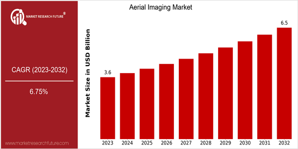
Market Size Snapshot
| Year | Value |
|---|---|
| 2023 | USD 3.62 Billion |
| 2032 | USD 6.52 Billion |
| CAGR (2024-2032) | 6.75 % |
Note – Market size depicts the revenue generated over the financial year
The Aerial Imaging Market is currently valued at USD 3.62 billion in 2023 and is projected to reach USD 6.52 billion by 2032, reflecting a robust compound annual growth rate (CAGR) of 6.75% from 2024 to 2032. This growth trajectory indicates a strong demand for aerial imaging solutions across various sectors, driven by advancements in drone technology, increased adoption of Geographic Information Systems (GIS), and the growing need for high-resolution imagery in applications such as agriculture, construction, and environmental monitoring. Several factors are propelling this market forward, including the rising utilization of drones for surveying and mapping, which enhances operational efficiency and data accuracy. Additionally, the integration of artificial intelligence and machine learning in aerial imaging technologies is enabling more sophisticated data analysis and insights. Key players in the market, such as DJI, senseFly, and GeoIQ, are actively pursuing strategic initiatives, including partnerships and product innovations, to enhance their service offerings and expand their market presence. For instance, recent collaborations between drone manufacturers and software developers are aimed at creating comprehensive aerial imaging solutions that cater to the evolving needs of industries, further solidifying the market's growth potential.
Regional Market Size
Regional Deep Dive
The Aerial Imaging Market is experiencing significant growth across various regions, driven by advancements in drone technology, increasing demand for geospatial data, and the integration of artificial intelligence in imaging processes. Each region exhibits unique characteristics that influence market dynamics, including regulatory frameworks, technological adoption rates, and sector-specific applications such as agriculture, construction, and environmental monitoring. As industries increasingly recognize the value of aerial imaging for decision-making and operational efficiency, the market is poised for continued expansion.
Europe
- The European Union's Horizon 2020 program is funding various projects aimed at enhancing drone technology and aerial imaging applications, particularly in environmental monitoring and urban planning, which is expected to drive market growth.
- Countries like the UK and Germany are leading in the adoption of aerial imaging for smart city initiatives, leveraging high-resolution imaging to improve urban infrastructure and services.
Asia Pacific
- China is rapidly advancing its aerial imaging capabilities, with companies like EHang and DJI leading the charge in drone technology, which is being applied in sectors such as agriculture and disaster management.
- The increasing investment in smart city projects across countries like India and Singapore is driving demand for aerial imaging solutions, as these technologies are essential for urban planning and development.
Latin America
- Brazil is emerging as a key player in the aerial imaging market, with initiatives aimed at using drones for agricultural monitoring and environmental conservation, supported by local government programs.
- The increasing focus on infrastructure development in countries like Mexico is driving demand for aerial imaging solutions, as they provide critical data for construction and urban planning projects.
North America
- The Federal Aviation Administration (FAA) has implemented new regulations that facilitate the use of drones for commercial purposes, significantly boosting the aerial imaging market in the U.S. This regulatory support is expected to enhance operational capabilities and expand service offerings.
- Key players like DJI and senseFly are innovating with advanced imaging technologies, including thermal and multispectral imaging, which are increasingly being adopted in sectors such as agriculture and infrastructure inspection.
Middle East And Africa
- The UAE is at the forefront of adopting aerial imaging technologies, with government initiatives like the Dubai Smart City project utilizing drones for urban planning and infrastructure development.
- Regulatory frameworks in countries like South Africa are evolving to support the use of drones in various sectors, including mining and agriculture, which is expected to enhance market growth.
Did You Know?
“Aerial imaging technology can capture images with a resolution as high as 1 cm, allowing for detailed analysis in various applications, from agriculture to urban planning.” — DroneDeploy
Segmental Market Size
The Aerial Imaging Market is experiencing robust growth, driven by advancements in drone technology and increasing demand for high-resolution imagery across various sectors. Key factors propelling this segment include the rising need for real-time data in agriculture, construction, and environmental monitoring, as well as regulatory support for drone operations in many regions. Companies like DJI and Parrot are at the forefront, providing innovative solutions that enhance aerial imaging capabilities. Currently, the market is in a scaled deployment stage, with notable adoption in regions such as North America and Europe, where industries leverage aerial imaging for precision agriculture and urban planning. Use cases include crop health monitoring, infrastructure inspection, and disaster management, showcasing the versatility of aerial imaging technology. Trends such as sustainability initiatives and the push for smart cities further catalyze growth, as stakeholders seek efficient and eco-friendly solutions. Technologies like LiDAR and photogrammetry are shaping the segment's evolution, enabling more accurate and detailed imaging, thus expanding its applications across various industries.
Future Outlook
The Aerial Imaging Market is poised for significant growth from 2023 to 2032, with a projected market value increase from $3.62 billion to $6.52 billion, reflecting a robust compound annual growth rate (CAGR) of 6.75%. This growth trajectory is underpinned by the increasing adoption of aerial imaging technologies across various sectors, including agriculture, construction, and environmental monitoring. As industries continue to recognize the value of high-resolution aerial data for decision-making and operational efficiency, the penetration of aerial imaging solutions is expected to rise substantially, with usage rates potentially reaching over 30% in key sectors by 2032. Key technological advancements, such as the integration of artificial intelligence (AI) and machine learning (ML) in image processing, are anticipated to drive market expansion. These technologies enhance the accuracy and speed of data analysis, making aerial imaging more accessible and valuable for end-users. Additionally, supportive government policies promoting the use of drones and aerial surveillance for public safety and infrastructure development are likely to further stimulate market growth. Emerging trends, including the increasing demand for real-time data and the rise of smart city initiatives, will also play a crucial role in shaping the future landscape of the aerial imaging market, positioning it as a vital component of the broader digital transformation across industries.
Aerial Imaging Market Highlights:
Leading companies partner with us for data-driven Insights
Kindly complete the form below to receive a free sample of this Report
Tailored for You
- Dedicated Research on any specifics segment or region.
- Focused Research on specific players in the market.
- Custom Report based only on your requirements.
- Flexibility to add or subtract any chapter in the study.
- Historic data from 2014 and forecasts outlook till 2040.
- Flexibility of providing data/insights in formats (PDF, PPT, Excel).
- Provide cross segmentation in applicable scenario/markets.